My cousin Burton stopped by the store, all excited about gold mining. He had already done a little sluice box work at Sixmile Creek near Hope and at Crow Creek Mine, but had very little fine gold to show for his efforts. I decided we needed to go out together so I could get him headed in the right direction.
It is a lot harder to find gold when you are starting out then most people imagine. The average person tends to assume that if there is gold on a creek, you just need to pan or sluice some material, and you will find some gold. The truth is just the opposite. Put a beginner on a gold-bearing creek, and they will be very lucky to find any gold at all.
Just because a stream is known to contain gold does not mean all the gravels in the valley have gold. Most of the gravels at any gold mine have little or no gold. The secret to successful gold mining is to identify which gravels contain the gold. You then try to process as much of this "pay material" as possible while avoiding moving worthless material as much as possible. Sounds obvious, doesn't it?
Placer gold is gold that by definition has been liberated from the original lode (hardrock) deposits and concentrated by water action. Most of the gold in Crow Creek originated in quartz veins upstream in the vicinity of the Crown and Jewel Mines at Crow Pass. As the gold eroded from the quartz veins, erosion carried it downhill into Crow Creek, where countless years of water action concentrated the gold into placer deposits. Look at a stream valley as nothing more than a gigantic naturally fed sluice box and you get the idea.
Running water is very efficient at separating materials by weight, with the heaviest minerals, including gold, working downward over the years. Massive floods do most of the work, as the entire volume of material in the bottom of the creek must actually be in motion for any concentration to take place. These floods are rare events, and are referred to by geologists as 20 year, 50 year, or 100 year floods, depending on the average amount of time that will pass before you see one of these floods occur. The larger the flood event, the rarer they are.
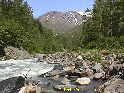
View up Crow Creek from Area #1
The last major flood on Crow Creek occurred in 1995, and it changed the entire valley. The creek changed channels completely in several locations, and eroded 10-20 feet lower into the valley bottom, leaving the old channels high and dry. This is how bench deposits are created, when remnants of old stream channels are abandoned and left above the new creek level as the creek erodes downward. Subsequent erosion and hillside mass-wasting will eventually destroy most hillside or bench deposits, putting their gold back into the stream. But some survive for hundreds or thousands of years to create today's bench deposits far uphill of the modern stream.
Crow Creek is more complicated than most gold deposits due to the fact that Crow Creek Mine is an artificial valley. The old stream valley is a small bedrock canyon just to the right of the parking lot as you enter the mine. The old miners discovered that prior to the last glacial advance, Crow Creek had eroded a valley much farther down into the material than the modern creek. The glaciers alternately dammed Crow Creek from below and pushed material over it from above, completely filling the old canyon and burying the old gold deposits under hundreds of feet of worthless glacial material. Crow Creek is rather unique in that the glaciers buried and preserved the old gold deposits, rather than gouging them up and destroying them. The gold deposits at Crow Creek are much older than most deposits on the Kenai Peninsula, which have only formed since the last glacial advance. This is one reason why Crow Creek is the richest gold mine in Southcentral Alaska.
The old-timers mined their way down to the bottom of the ancient stream valley. The top material was nearly worthless glacial material. It does contain some gold, but the material has not been concentrated by stream action and so the gold is scattered haphazardly through the material. A large exposure can be seen from the parking lot by looking directly across the valley. It is mixed round rocks and gravel, with no apparent layering, and is generally very light tan in color. The layer is over 150 feet thick, and the nearly vertical exposure is now slowly falling into the old mining excavation below.
Below the glacial till the miner finally reached old streambed deposits. I refer to these as the "brown layer" as the material usually contains lots of yellow-brown clay. When processed in a pan or sluice you gets lots of muddy brown water. In some areas this layer is saturated with water and relatively soft, but much of it is very compacted and tough to dig. In some places a pick is needed to break out even small chunks of the material. The material consists of rounded rocks and gravels, and contains many boulders, usually larger than the rocks in the overlying glacial material. In some exposures it is obvious as a "bouldery layer" sandwiched between the other layers.
The brown layer was the rich layer, and produced most of the gold mined at Crow Creek Mine. The gold in the layer can be very concentrated, with some material running up to six ounces of gold per yard of material! The gold is coarse and chunky, with match head sized nuggets common and larger nuggets running up to several ounces. This was the "pay layer".
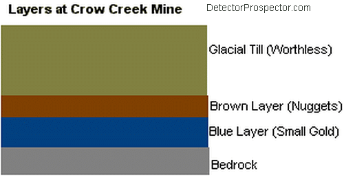
Layers of material at Crow Creek Mine, Alaska
In the lower portion of Crow Creek valley the brown layer often rested directly on bedrock. Most of this area has been completely mined and is the canyon portion of Crow Creek below the parking lot that is off-limits to the general public. A series of old bedrock channels were uncovered and mined to their bottoms. This area was then used as a tailings disposal area as mining proceeded further upstream. There are still remnants of the brown layer resting on bedrock in lower Area #1.
When the miners got to what is now referred to as "Area #1", in other words, the first mining area you reach as you walk up the creek, they found another major layer below the brown layer but over the bedrock. Walk up the trail and turn down to the creek at the Area #1 sign. You will see lots of bedrock exposed on your right, with the creek cutting a narrow gorge through the bedrock. But oddly, as you look upstream, the bedrock disappears. There is a large bowl, or depression in the bedrock above this point, and bedrock is only exposed at one other location on the creek above this point at the upper end of Area #1.
This depression at one time must have had a glacier upstream of it, for it is filled with a dense, dark layer of material I refer to as the "blue layer". The layer has a distinct bluish-gray color because it mostly consists of clay formed from glacial silt. It has many small, angular rocks mixed with it, and hardly any rocks over a few inches in diameter. It can be relatively soft in it's upper reaches, but as you dig down it becomes very tough and eventually turns into rock. There is a good exposure of this layer turned into a conglomerate rock directly against the bedrock across the creek in Area #1. The layer is dozens of feet thick, and may be over 100 feet thick further upstream. The brown layer, instead of resting on bedrock, rests directly on top of this "blue layer" from Area #1 and upstream.
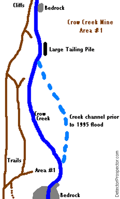
Map of Area #1 at Crow Creek Mine, Alaska
The blue layer is "glacial outwash", in other words material that flowed out from streams issuing from the face of a glacier. The layer is mostly silt and clays formed from silts, and small rocks that have not been rounded by stream action. There is only small, fine and flaky gold in the material, and since it is very tough it tends to roll through sluice boxes in chunks without breaking up. At some locations it is rather "sticky" and can actually pick up gold out of a sluice box as it rolls through.
The absolute richest material that you can find at Crow Creek Mine is where the brown layer rests directly on bedrock, or where it rests directly on the blue layer. The brown layer was once streambed material in motion. The gold tended to work to the bottom of the brown layer, and very rich pockets of coarse gold can be found in bedrock crevices below the brown layer, or in the top few inches of the blue layer where gold worked into the clay's surface. The clay did not have a smooth surface, but many depressions and pockets where gold could lodge. Rolling rocks literally hammered gold into the top few inches of clay. But don't dig too deep into the clay, as there is usually little gold under the top few inches. There is gold throughout the entire brown layer, and most of it is worth running through a sluice or highbanker. Like all layers, however, it does have its barren areas.
So, to recap. We have glacial material, over brown layer, over blue layer, over bedrock. From Area #1 downstream the brown layer may rest on bedrock, but there are sections of blue material below Area #1. From Area #1 upstream the brown layer rests on the blue layer. There is one final layer we must discuss. The tailings layer. It is the final layer that can produce large amounts of gold for the miner at Crow Creek.
The miners started mining Crow Creek near the end of the valley, then proceeded farther and farther upstream. The old-timers were using hydraulic giants, or huge water cannons, to strip the overlying glacial till away, then process the brown layer through a series of wooden sluices. The high volume of material processed caused lots of smaller gold to be lost into the tailings. In some areas, gold washed over the blue layer got caught in pockets and depressions and never made it into the sluice boxes. In Area #1 the brown layer has been almost completely removed, and what remains is the blue layer, covered with loose tailing material. The old miners excavated into the blue layer about 50 to 75 feet at Area #1, so the creek is actually now running in a mini-valley in the blue layer well below where the brown layer existed. From creek level at Area #1 you need to walk at least 100 feet up the hill or more to find any brown layer material remaining.
The tailings do contain gold, and the floodplain in Area #1 consists of tailings less than ten feet thick lying on top of the blue layer. Floods have reconcentrated the tailings, and most of the gold contained in them has settled to rest directly on the blue layer. The creek ran against the far bank before the 1995 flood, but now rests in a channel closer to the trail. The foot of material where the tailings meet the blue layer can be very rich, and I have taken a lot of gold from Area #1 over the years by staying on the blue layer.
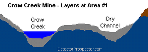
Stream cross section Area #1 at Crow Creek Mine, Alaska
The trick to Area #1 is simple. If you dredge in the creek (and I have) there is little gold in the overburden. You get 95% of the gold directly off the blue layer, where it is lodged in small pockets and depressions. The blue layer was severely eroded by the flood, and in the middle of the current stream channel is about 3-5 feet from the surface. It is very tough and very much like soft asphalt in consistency. The layer rises away from the center of the creek until it finally runs up out of the water. The entire floodplain, and the old dry channel against the far bank, and completely underlain by this layer. Remember that during major floods, the entire floodplain is underwater and all the gravel is moving downstream. Gold is concentrated on the blue layer across the entire floodplain, and many rich pockets will be encountered well away from the current creek channel.
If you dredge the creek, you are forced to process the generally worthless tailings on top to get rid of them, but you get little gold doing so. Getting to the blue layer is the key. The blue layer was exposed directly on the surface of the far side of the creek after the flood, and I did quite well with a metal detector along the edge of the creek. Unfortunately, as you follow the layer away from the creek, the tailings get thicker, and contain many large rocks. Most of the material is worthless, so much so that the best strategy with a shovel is to simply throw it aside. Only the foot of material directly on the blue layer should be processed through a hand sluice. You may toss a little gold with the tailings, but if you waste too much time processing generally worthless material, you will get less gold, not more. Finally, if you use a metal detector, get to that blue layer! Detecting the material directly on top of the layer will get you nuggets. Detecting the tailings will get you iron trash of every description.
Area #1 is being overlooked by the public at this time. This will no doubt change next summer after this report gets around. Tourists all cluster in Area #1 on the near side of the creek. The real place to hit is the floodplain area across the creek. Therein lies the problem. You can only wade the creek in the early spring or late fall. Midsummer there may or may not be a bridge crossing way upstream where you can cross, then walk downstream to the floodplain, but there is no good trail.
Burton and I loaded up a hand sluice and digging tools and headed for Area #1 on a wonderfully sunny day. We crossed at the log bridge in upper Area #1 and bushwhacked downstream to the floodplain area. I pointed out little bits and pieces of the blue layer showing along the edge of the creek to Burton. The area we chose had the layer running under 3-5 feet of overlying tailings, but had the advantage of being directly next to the creek. We set the sluice box up directly next to the bank where we could shovel directly into it without using buckets. We could throw large rocks and the worthless overburden over the sluice into the creek, which was a raging torrent this sunny day. Crow Creek is fed by a glacier, and if you are on the far side keep in mind that it rises steadily everyday with the temperature. Crossing over early in the morning can make for a risky return later on a hot day.
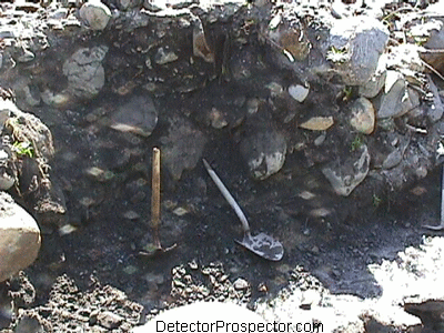
Removing overburden to get to gold bearing layer
We got with the program, and started clearing off the blue layer. We would knock off a portion of the bank to remove overhanging rocks, then toss and shovel until we were about to the blue layer. It's easy to tell when you hit it... it's really like digging pavement! Then we carefully scraped the few inches off the top of the layer and fed it through the sluice. Burton got real excited when gold started showing up almost immediately.
Here is a good picture of the blue layer as we exposed it. The water was rising throughout the day, and so slowly crept up over the layer as we worked. This same spot will be high and dry in late fall as water levels drop. You can see the cement-like quality of the layer. In some places in upper Area #1 the layer is pure clay with no rock, in other spots like this there is a lot of rock in the clay. It actually makes a good rough surface for catching gold, but unfortunately it is soft enough that the material is constantly eroding during a flood and releasing the gold as fast as it traps it. Most of the gold gets caught right where it is when the flood starts to subside, and the material stops rolling and eroding.
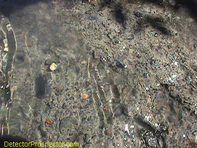
Close up of clay "blue layer" exposed underwater
One thing this day reminded me of... I am not a big fan of shovels! The day was very hot, and we were sweating like pigs throwing rocks and dirt. The water kept rising, making it hard to scrape the blue layer clean, and causing me to worry a bit about our return crossing over the log bridge. The water had been touching the logs when we came over as it was. We had a nice amount of gold to send Burton home with, more than all his previous trips combined had found, so we called it a day. We pulled the sluice up, washed it into a pan and panned the day's take.
A couple pennyweight of chunky little nuggets looked up at us from the gold pan. Burton was ecstatic, and thrilled about this new revelation about finding gold on layers, or "false bedrock" as it is often referred to. It really is the key to success at Crow Creek, and at nearly all other placer gold mines, especially in Alaska. I have visited numerous large mining operations, and nearly all operate by stripping worthless overburden as cheaply and quickly as possible, then running only the likely gold bearing material through the recovery system. This is usually material on or in actual bedrock, or sometimes on a false bedrock layer, like the blue layer at Crow Creek. Learning the same principle of "identify the pay layer, and process only likely pay material" will go a long ways towards helping many weekend miners to increase their chances of finding gold.
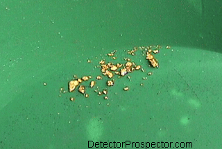
Chunky gold from pay layer
A few final notes. I've given you generalities here, and there are things to look out for. The tailings are usually relatively loose gray materials with lots of iron trash. In the upper areas of Crow Creek, the tailings had more mud in them, and some of these tailings appear to be the brown layer. In fact, they are brown layer materials that have been processed, and where they were dumped in some areas they rehardened into what appears to be virgin material. Like all the tailings, it can have good gold in it, but it has been through a sluice box. The dead giveaway is nails. If you are finding nails in it, it must be tailings.
The other thing to watch out for is that in Area #2, the brown layer and blue layer do not always have a clean dividing point, but appear as alternate layers. In other words, you dig down through the brown layer, hit a blue layer, then dig through it and hit another brown layer. This indicates some kind of repeated pattern of gold deposition followed by glacial outwash, then more gold deposition. It can get interesting, as hitting the blue layer usually means stop, but in Area #2 you may hit another brown layer farther down.
I'll focus on the brown layer and the upper areas of Crow Creek in a future article. Until then, Good Luck to all you miners out there!!
~ Steve Herschbach
Copyright © 2001 Herschbach Enterprises
-
 1
1