Well, I've been kind of quiet lately about a trip I took last week. But the papers have been filed and so now I can spill the beans.
This is a long story, so bear with me. There is a creek in the McGrath area that I have been aware of for 30 years. I first visited Moore Creek in 1973, actually as a detour from Flat, Alaska. I had researched out the Flat area as being a likely place to look for gold, and talked my father into flying me there. But when we got over the area there was all kinds of obvious activity below and so we turned back towards Anchorage in disappointment. On the way back we flew over some old mine tailings that looked inactive. We landed and poked around a bit. My father and I panned nice quantities of coarse, quartzy gold... and the place has had my attention ever since. I actually refer to it in another story I have online but the reference passed unnoticed by most. Moore Creek is the first place I ever tried to use a metal detector to find a gold nugget!
An old-timer named Don Harris held the ground for decades. We got to know Don and visited the mine several times over the years. I let it be known that I was interested if he ever decided to sell the place. I was dismayed when he sold the ground a couple years ago to someone else but understood as it was someone he knew well in the McGrath area. But a few weeks ago I got a call from the new owner. Family issues demanded he leave the area and so he wanted to sell, and he had been advised by Don to give me a call. I jumped at it. The price was out of my range, so a limited liability company was formed by myself and three partners to buy the claims.
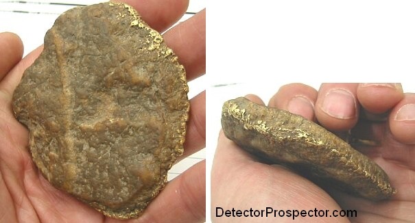
Large gold specimen found by previous mine owner at Moore Creek
We got the core 480 acres but some of the surrounding ground had lapsed over the years. I went in last week with my father (one of my partners), and we spent 95% of the time on claims work, including staking 4 more claims comprising 520 acres of ground. So the total property is now 1000 acres. I did find time to prospect a bit, and found a 1/4 oz nugget with my detector and some other gold, but I had little time to devote to metal detecting this trip. Enough time for that down the road.
Anyway, we got the additional ground staked, and paperwork fired off to Fairbanks via Express Mail as soon as we returned to Anchorage. So the new claims are now recorded and I can relax a bit.
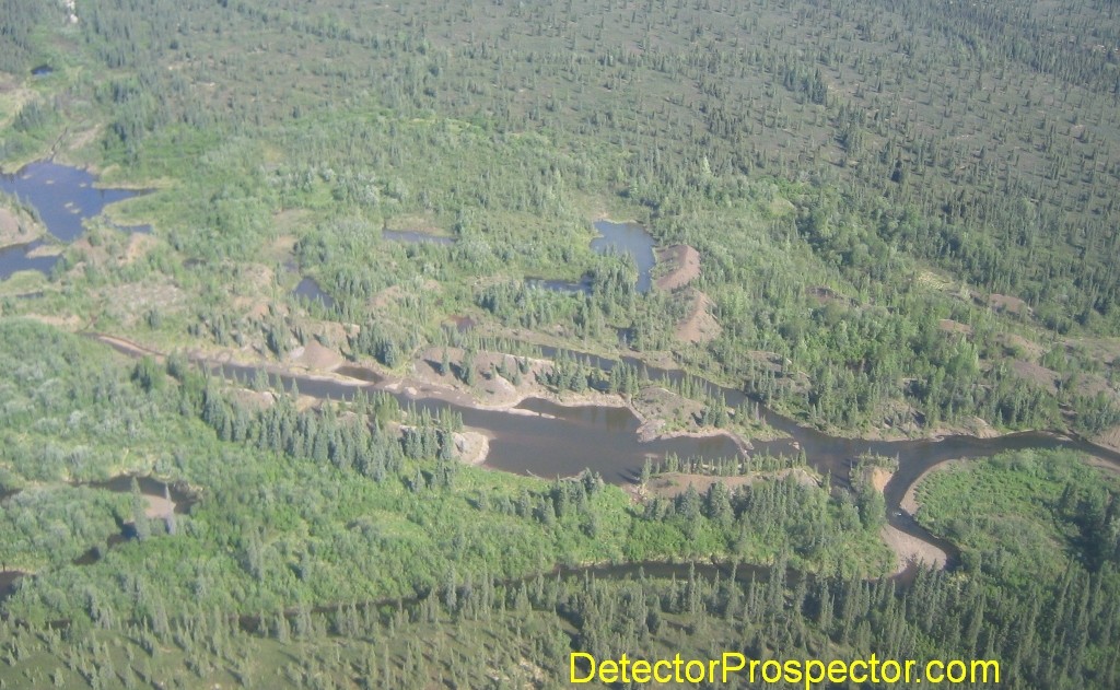
Aerial view of old mine workings at Moore Creek, Alaska
Why have I been interested in this ground so long? Well, it has produced over 60,000 ounces of gold by rather conservative estimates. The creek has a long history, and the information on the early years is sparse. A nugget over 100 ounces was found in the old days, but recent times have seen nuggets of up to 20 ounces. The kicker for me is that the gold is extremely rough, much rougher than even Ganes Creek gold. Lots of quartzy nuggets, and many that are just sections out of thin, super rich gold veins. I can just smell the hardrock gold! This was driven home by the chunk of quartz vein shown below which the previous owner found metal detecting on the claims.
But unlike Ganes the hardrock source has a been narrowed down to a very small target area. The source lies uphill of the creek, and a couple small veins have been uncovered. Battle Mountain moved in to do drilling work in the 1980's, but claims disputes kept them from the actual work and then the price of gold collapsed. The ground never was drilled So while the hardrock is there it has seen minimal exploration. Until the hardrock prospect is drilled it will never be known how much gold remains in the hill. The big question is whether there is substantial hardrock gold still in place, or has most of it eroded to form the creek placers? Nobody knows the answer to that... yet. I've got the whole hillside staked and hope to find some of the answers eventually.
My main goal was to just get the ground for now. We have already started cleaning up the camp from years of neglect and clearing the inevitable alders that have grown over trails and such. But we will stay low key and simply develop and explore for some time, doing lots of sampling and getting a feel for the potential of the ground. I'm curious how much of the quartzy gold was lost by the old miners into the tailings, and if their old workings are worth re-mining. There is some potential for virgin ground that needs to be nailed down. And the big question is the hardrock. All good questions that will take lots of sampling to get answers.
So there you are. I ditched my last claims as they were tying me down and I wanted to be more free to bounce around the state. Now I'm tied down again, and the future will no doubt see me spending most of my free time at Moore Creek.
Now you know why I was not back at Ganes Creek this summer. Though Ganes Creek is just 40 miles away. If you draw a line from Ganes Creek to Donlin Creek, another big new strike in Alaska, Moore Creek is midway between on the same mineral trend. Good neighbors to have! If you are interested a Geologic Report on Moore Creek is available in pdf format at http://www.dggs.alaska.gov/webpubs/dggs/pr/text/pr096.PDF
So I'm a very excited guy right now. But also mourning the fact that my trips to Nome and the Coldfoot area have once again been shelved. Just not enough time...
For now we are just doing claims improvements and exploration. We need to get established and get a better feel for the potential. There is a lot of work to be done upgrading the facilities. Item #1 is the airstrip. It's about 1400 feet, just enough for a 206 but scary for a 207. Even the 206 is pushing it somewhat if the wind is unfavorable. I just got back from a meeting with some miner friends and they have talked me into getting a permit to lengthen the runway. Did I mention I have a couple of old D9 cats? So I'm rounding up the paperwork and getting the application in for that. I'll probably just go an APMA for five years for low-level exploration activities. Luckily the current state political environment is quite favorable compared to previous years and this should be no major problem, aside from those normally associated with filing for permits.
View looking up old overgrown airstrip at Moore Creek Mine, Alaska
There are existing cabins in place that I need to get approval to use in the APMA. We own them and their contents, but existing cabins are a sticky issue on state land. Technically the state wants them removed at the end of mining activities. But as operations are ongoing and open-ended at the moment it's mostly just a matter of getting proper permits to use the cabins for now. The theory is we own the cabins and contents but do not have permission to have them on State land yet! So I'm getting up to speed on all the ins and outs of state claim ownership. In general, it's considered far better than owning federal claims nowadays, as the state looks at claims and mining as a revenue source to be more or less encouraged. The feds seem more inclined to just make mining claims go away.
Setting up the LLC (Limited Liability Company) was really easy. Every state has it's own process, but it's basically the same. In Alaska you go the the Alaska Banking, Securities, and Corporations website and download the application. It is all of two pages. Fill it out, and file with a $250 filing fee. It's somewhat like a business license as you have to renew every couple years. An LLC is a cross between a partnership and a corporation. You manage it like a partnership but it affords you most of the legal protections against liability of a corporation. You also need an operating agreement to really cover yourself against things like partners dying, etc. Generic agreements can be had and modified to suit. Your liability is essentially limited to what you have invested in the LLC, in this case our claims. If it turned out we had an EPA toxic waste site on our hands we could walk away. We would lose what we invested in the claims, but they could not come after my house or my business. At least, that's the theory!
Getting the LLC set up was a key first step. With this done a business checking account was the next step. Monies were deposited by the LLC members, and the claims purchased using a Quit Claim Deed for Mining Claims Form found at the DNR website. This form must be filled out and notarized, then filed with the Recorder's Office. We executed a second Quit Claim Deed on all rights to structures, tools, equipment on the claims. Exclusions were noted on some items the old owners want to retrieve.
That done, the ground was examined for potential claims on surrounding land. These claims were staked using Alaska's new MTRSC forms located at the DNR website. A factsheet on the process is found at is also found there. A copy of the form is put on the NE #1 corner of each claim while staking. Our claims are located in the Mt. McKinley Recording District, and that means documents are recorded in Fairbanks. Kind of silly in this day and age. But that's the way it is. A copy of the claims form is filed with the Recorder's Office, in this case via Registered Express Mail. You actually have 45 days to file the paperwork but why delay? I always fear paper stakers mucking up the process and so I want to get on record ASAP.

Old cabins at Moore Creek Mine, Alaska
The only part of the whole process I found confusing was the filing fees. Since all the paperwork for four claims was being filed at once, was it $15 for the first page, and $3 for each additional page? Each claim form had a plat copy attached with existing and new claims plotted, so each claim had two pages - eight total. I finally called the Recorders Office and the very nice lady that answered told me $15 for each claim form of one page, plus $3 for each attached page. So it was $15x4=$60 plus $3x4=$12 for a total of $72. I also paid $2 per filing, another $8, to have copies returned immediately. I was told I did not need to pay for postage for this but I enclosed a self-addressed stamped envelope anyway.
Rental fees are also due on new claims. You can pay at a later date but have the option of paying at the time of filing if the calculation form with the MTRSC Form is filled out. I elected to pay the fees at time of filing. The initial Alaska rental fee is $25 per 40 acres. We filed three 160 acre claims and one 40 acre claim so the initial fee was $325. The fun part about that is the fees expire in September and must be repaid by the end on November for next year. The only way to avoid this was to wait until after September 1st to file the new claims, but we did not want to wait that long. Besides the risk of someone else staking the ground weather gets very dicey in September in Alaska and we might have access problems.
The MTRSC system is sweet. You basically stake claims by the quarter section (160 acres) or quarter-quarter section (40 acres). The old claim system can still be used for claims where section corners do not fit the actual deposit well, but in this case it was fine. The advantage is that it is easy to pre-map the claims, and calculate Latitude/Longitude coordinates for the corners. This is all done in advance, claim forms filled out, etc. I had all the claim corners input as waypoints in my GPS. So once you get on the ground you use your GPS to get to each corner. I also had little metal tags prefilled out with corner identification info for each corner. Doing this all in advance at home saves a lot of frustration in the rain and the brush!
GPS is fine for claim staking... you are not doing an actual survey. My Garmin would get me close but when you get to the spot a GPS gets flakey and you find you can't quite get a fix within the last 40 feet. It does not matter. Just get on location and if you are in the right terrain find the best close tree to use as a corner post. I had to actually dig posts in at a couple spots but most of my corners ended up being trees. The marked corner on the ground is the actual legal corner, not the GPS coordinate, so keep this in mind when placing the actual corner.
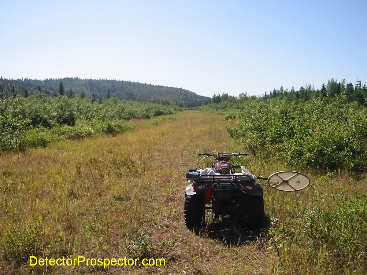
So the hardest part was just doing it. I scoped the corners by aerial photos, but reality on the ground is harder than when you are looking at aerial photos. It all looks so easy when looking at the photo, but get on the ground and thick brush and wet areas make it more fun. Still, we are not talking a vast number of claims and distances here, and since I had plenty of time I took one day to do two claims and another day to do the other two.
So that's it up to this point. I'm now looking over the Annual Placer Miners Application found at the DNR website to proceed to the next step.
I did do some detecting, almost as much to find out where the old trails were as much as to go find gold. Here are the few nuggets I found. The largest, at 4.7 pennyweight (20 pennyweight per Troy ounce) was off the top of a large tailing pile well below camp. Just like at Ganes Creek. It's fairly quartzy but thick with gold. The next is about a pennyweight and solid gold and came off bedrock just above camp. The smaller ones all came off bedrock at the uppermost workings above camp.
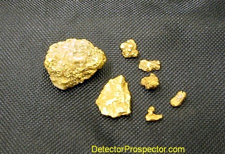
A few nuggets found on claim staking trip
The ground is exactly the opposite of Ganes for detecting. The bedrock is fairly neutral, but the cobbles are strongly negative and positive. So when ground balanced to the background you get both big "boings" off negative rocks and strong positive gold-like signals off positive rocks. I had a Fisher Gold Bug 2 and my father was using his Tesoro Lobo SuperTRAQ, both of which we have used with great success at Ganes Creek just a few miles away. But here at Moore Creek the ground noise was such that we had to use the detectors in their iron rejection modes just to operate. The iron id systems rejected the rock signals, but the signals were so powerful that the machines clicked and blipped constantly. Still, you can tell a good signal from these hot rock overloads with no problem
Anyway, there was little time for detecting this last trip. I'll be headed back the first week of August to give it a more serious workout, so I'll have a better idea after that as to the detecting potential of the ground. There are old detector holes scattered about, but other than a couple nuggets I have no idea what they were finding. All the holes were very shallow indicating older, less powerful detectors were used. I'll be using my Minelab GP 3000 here in the future as it is obvious the hot rocks are a real issue at Moore Creek, and the GP 3000 deals with difficult ground better than any other detector made.
I've been inundated with inquiries and rumors regarding our intent for these claims. Everyone assumes it is intended as a Ganes Creek style operation. It actually was not the intent in acquiring the claims. The real thing that happened here was a great opportunity arising and being taken advantage of. While we have discussed the possibility of a Ganes style operation there are issues with the State on doing a non-mining business on mining claims. As in... you can't. So to just advertise out as a tourist operation is a no-no. State mining claims are for mining.
That is not to say that metal detecting is not a legitimate form of mineral extraction. Obviously I can use a metal detector to efficiently recover nuggets from tailings that would prove uneconomic if mined by traditional methods. I could hire a guy to look for gold with a metal detector if I thought it would pay (and I could trust him!). Mining also has a long history of work being done for a share of the final cleanup, and so percentage deals are a legitimate form of mining. I am a professional detectorist and have made quite a few miners happy splitting my finds with them 50/50 and locating potential mineable ground at the same time. It's not recreational, it's mining and prospecting. It's all in the intent.
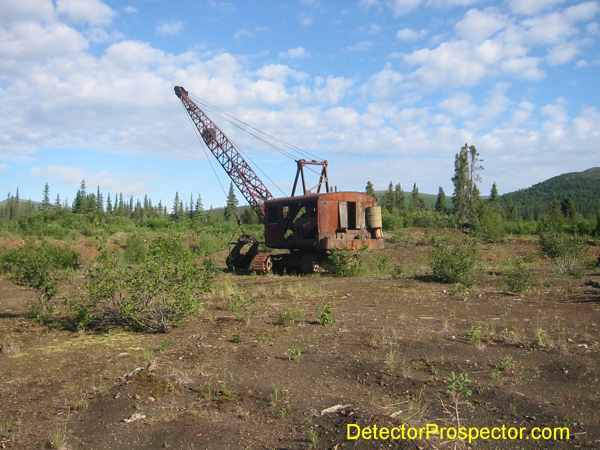
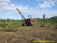
Old Northwest dragline parked on Moore Creek property
But I digress. The Moore property has tremendous mining potential. The Iditarod-Nixon fork Fault is one of the most important mineralized gold structures in Alaska. The Iditarod Mining District is the fourth largest gold producer in Alaska at 1.5 million ounces. There is a high potential on the remaining placer resources at Moore Creek and good potential for the hardrock. In fact, the hardrock is what has my main interest. The placers may simply serve as a way to keep the property active while exploring for hardrock. I have one located vein on the property, but it takes more than that to prove a mineable deposit. Basically, it takes drilling, not an inexpensive thing to do in Alaska.
The immediate goal is to clean up the access and start sampling of the placers interspersed with hardrock prospecting. The vein has been traced for about 300 feet but both ends are covered by topsoil and brush, so trying to establish it's overall length is an obvious early step. It needs more assay work to determine it's tenor. I really do not think this vein is THE source I'm after, however. What you need these days is lots and lots of veins in a fairly large area to make it mineable by open pit methods.
So people need not hold their breath waiting for some big announcement about a Ganes style operation at Moore Creek. It's not impossible something like that may be worked out someday, but for now we have other plans for Moore Creek. The more we talk about it the more excited we get. My partner Dudley is already shopping for dozers and excavators and getting shipping costs. This guy is getting gold fever! My father called today all excited about using simple seismic or ground penetrating radar to search for deep channels in the main streambed and then firing up the churn drill to sample.
Big picture factors are playing into this also. The economic structure of the U.S. is getting shaky (big deficits soon to be followed by the printing of more money) and so the future of gold is looking brighter. Inflationary times are always good for commodity prices. The Donlin deposit is looking more like a go all the time, and if so we could just find ourselves with a road system and a world class mill nearby. The Kuskokwim region could explode development-wise over the next few years. These are good times to be sitting on a gold mine, and the Iditarod area is a good place for that mine to be.
Anyway, I'm working on my Annual Placer Miners Application (APMA) now, and hope to file it soon. The APMA is a single application that is then sent to all the appropriate agencies for approval (and no doubt additional requirements) and it is a real nice system. You do not have to chase down separate forms and make separate applications with a bunch of different agencies. They can cover you for up to 5 years, which is what I'll be shooting for. They can also be amended as needed. Once I get it filed I'll keep everyone up-to-date as to how long it takes and what problems crop up.
~ Steve Herschbach
Copyright © 2003 Herschbach Enterprises