Jump to content

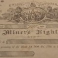
Old Gold Diggings On Magnetic Island And National Park Borders


Recommended Posts

I thought I'd take a closer look at which of Magnetic Island's old gold diggings are within the borders of the National Park.. The first image is a map of the island showing the National Park borders.. the second image is a Google Earth map showing the locations of the old gold diggings.. 


Map-of-Magnetic-Island.jpg

Screenshot 2021-03-20 at 1.16.33 PM.png

  • Like 2
Link to comment
Share on other sites


That is some nice areas to hunt, but it looks like you have to stay off the mountain areas. I can see where you can go up to the mountain sides, but not much further than that. I think I would be in the creeks and at the base of those ridges.

Good luck and I hope you can pin point the exact areas you can hunt in.

Link to comment
Share on other sites

Erik your first Google map showing the National Park borders appears out of date? A quick 2min Google shows the National Park area has increased by 31% over the last decade.

The attachment with red borders shows the boundary in 2012. The red borders as at 2020 are now part of the National Park too according to this: http://www.minca.org/news-archive/national-park-expansion-for-magnetic-island

The other attachment is a map of the National Park walking tracks. Unfortunately both maps that I found appear to show much more area is covered than your first map does.

The only way to be sure would be to get a current map from National Parks or whoever looks after Government/Crown lands in Queensland i.e. in NSW I would go to NSW Department of Crown Lands (if not NPWS directly) but not sure of the equivalent in Queensland. 

If it were me I'd want to be 100% sure through the correct & most up to date map/information from the right department.

I don't trust Google maps for accuracy. Local to me it shows an area as State Forest (state forest is allowable for fossicking in NSW under permit) but I know it was handed to National Parks in 2008 making it off limits. Easy to see how we could find ourselves in the wrong place without thorough research.

Hopefully you can find some areas there that are allowable to prospect.


791018085_orig.png

Magnetic-Island-Map-1024x681.jpg

  • Like 3
  • Thanks 1
Link to comment
Share on other sites

13 hours ago, AussieMatt said:

Easy to see how we could find ourselves in the wrong place without thorough research.

Thanks a lot for this AussieMatt..

The map I've shown is still used by Google and is on most tourist brochures.. even though my map showed old gold diggings outside of National Park borders, most of them are in some other sort of protected area.. for example 'The Dot' is within the Bolger Bay Conservation Area and the unnamed mine on the beach (bottom right on the map) is within a Marine Park.. Whilst the most obvious old digging outside National Park borders is in Horseshoe Bay, it is in the middle of a Skate Board Park (I'm joking).. 😁.. All this means there's very little wriggle room for prospecting on the island.. 

16 hours ago, Valens Legacy said:

I think I would be in the creeks and at the base of those ridges.

Good advice Valence Legacy! Some of the creeks from the old diggings flow into people's backyards or onto public beaches.. I've thought about beach panning/sluicing but am unsure about what can of worms I'd be opening in regards to regulations.. It's probably a hanging offence here in North Queensland (I'm joking).. 😁..       

  • Like 3
Link to comment
Share on other sites

Create an account or sign in to comment

You need to be a member in order to leave a comment

Create an account

Sign up for a new account in our community. It's easy!

Register a new account

Sign in

Already have an account? Sign in here.

Sign In Now
×
×
  • Create New...