
.jpg.315e3bd3307813c91df4930dc3a75102.jpg)
.jpg.293641b40a2864a235c8373d8149020c.jpg)
Jim in Idaho
-
Posts
762 -
Joined
-
Last visited
-
Days Won
2
Content Type
Forums
Detector Prospector Home
Detector Database
Downloads
Posts posted by Jim in Idaho
-
-
Update - I'd take $450 + shipping, or $525 shipped, with the aluminum case I made.
-
 1
1
-
-
Yup, Chuck, I hated that coil. IMHO, the Miner John 8 x 12 is lighter, more maneuverable, and more sensitive.
Jim
-
1
-
-
I've found, in my long life, that a little hostility is often needed. I remember, long ago, I told my quiet, nice partner, that I was going to turn over a new leaf, and be a really nice guy for our entire busy season of construction work. Near the end of the season we had a problem that nobody would solve, so I lost it and reverted back. That fixed it. My partner walked up, stuck out his hand, and said "Welcome back", with a grin. That ended that experiment....LOL
Jim
-
2
-
 1
1
-
-
This is now the world we live in. The old world of people being professional at their jobs, regardless of the level of that job, are now gone. ie. Boeing, Ford, Dodge, and others. Better get used to it.
Jim
-
2
-
 1
1
-
-
I was in the Air Force 4 years after the quake. I remember a buddy from Anchorage that had an album full of pics of the quake damage. Can't even remember his name now. I remember being astounded at the damage.
Jim
-
2
-
-
Ya know, the Navy did a whole bunch of research at their facility on Priest Lake here in Idaho. They were researching ultra-low frequency communications for talking to the world-wide fleet of submarines. Would be interesting to know what freq they ended up using, assuming you didn't go to jail for espionage...LOL. I thought your idea was pretty good. If I remember right it was useful for more than precious metals, too....like rare earth minerals. I'm still getting into the data-logging with the two box deep detectors, though haven't been doing anything with it since winter set in. Start of March we had bare ground, and then the blizzard hit and we had 15" of snow, and single digit temps, and that took care of spring for awhile. Snow's gone now, but we got 3/4" in one squall this morning. I think I'm still looking at a month before I can do much. Looking forward to at least one trip to your area this summer.
Jim
-
1
-
-
1 hour ago, jasong said:
With seismic (sonic) waves, you are not measuring strength but instead measuring the refracted or reflected impulse that results from the interface of two different materials which two different velocities which sound travels through it. You are measuring the initial impulse (thump) time and then measuring the arrival time at an array of sensors. It's all time based. Signal strength is only really relevant insomuch as you want a strong enough impulse to travel as deep as you need it to go., but how strong it is is mostly irrelevant.
Velocity is a function of time, distance between sensors is known, thus time is your critical measurement for this type of subsurface imaging.
Similarly like with sound waves - EM waves travel through different rock types with different velocities. So you can use very similar methods to measure time and determine where formations change. In this case it's not so much the density of the rock (as with sound waves) as it is the conductivity changes in the rock.
Seismic refractometers (oilfield thumpers) are an example of the sound wave frequency range tools.
GPR are an example of the EM frequency range tools.
There are cool tricks to measure the speed of light (actually, less) over tiny distances, since it's often faster than 1 cycle of the fastest CPU's. These can be employed cheaply, and is one reason why I've been saying GPR needn't be as expensive as people think it is, it can be a "pro-sumer" level tool, and it already is decreasing in price rapidly plus has drone mounted options.
Yeah...after watching the entire video, I'm starting to understand how this works. Mainly, it's a ton of calculations to arrive at a conclusion. I can also see why it's now becoming useful. Wasn't that long ago we didn't have enough computing power and speed to do the calculations. It' sort of a play on the old "give typewriters to a large enough group of monkeys and eventually they'll produce the works of Shakespeare"....LOL, but with hi-tech enhancements. Hoping all is well with you, Jason. I imagine, like me, you're itching to get out prospecting again.
Jim
-
6 hours ago, jasong said:
Not me, but Jim has. 🙂
Separately, a company I sold a project to did some resistivity surveys with a professional contractor. That contractor ended up unfortunately lighting a part of the mountain face on fire in doing so a few years back!
Still seems to me, Jason, you'd have to know the strength of each random noise source, relative to each other in order to make it work. GPS works because the initial impulses are at a set timing, so distance can be calculated at the receiver, and compared to other delays to calculate angle, and thus location. I'm still not confident that random noise would be much use, other than having the random noise from a known source location. Even then you'd have to know the comparative distance from each sensor in order to determine the earth effects. Maybe I'm just slow....LOL
Jim
-
Looks like pieces of a citrine quartz nodule.
Jim
-
9 hours ago, GotAU? said:
Their system is scanning multiple frequencies, but not only that it’s also looking at patterns at each frequency, so I think it can identify individual types of vibrations by that and follow it as it traverses through the landscape. It’s using timing to determine how dense the material is that those pulses or vibrations are traveling through along the array. Anywhere the signal slows down would indicate a change in density of the ground at that point. They can determine depth by the distance between the sensors as well. I think it’s pretty cool technology, and the resulting maps are interesting.
Of course it doesn’t replace groundwork, someone has to go out there and identify what the different density materials are and if they’re worth digging up.
I can see how that would work, assuming lots of sensors over a wide area. But seems to me it would lack much resolution. It's interesting, but probably has a long way to go. Might be pretty good for really large deposits.
Jim
-
I'm curious how they can use random noise, at unkown distances, to determine anything. I can see how known power going into the ground, at a known point, being used however. I also see how measuring the ambient soil voltage could indicate a conductive ground anomaly.
Jim
-
From
1 hour ago, Magic12 said:Since I own most of the 2 box ever made
just a note the whites tm800 has square antennas and runs at 12khz
while the tm808 antenna is oval and runs at 6khz
tm600 and tf600 same 6khz
tm800 and tf900 same 12khz
there is another Vercion of the tf 1200
than is the tf900 but with heigher voltage
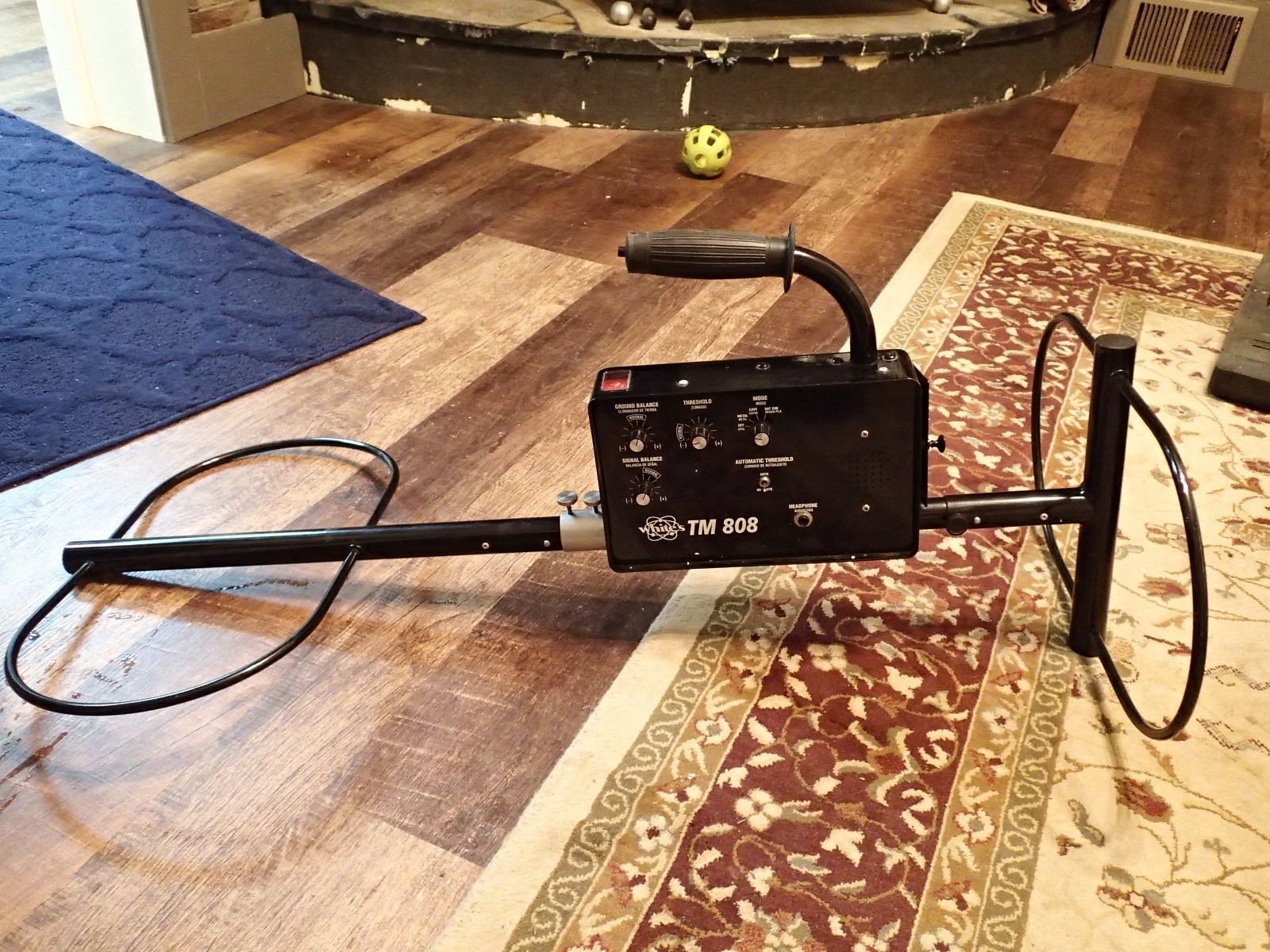
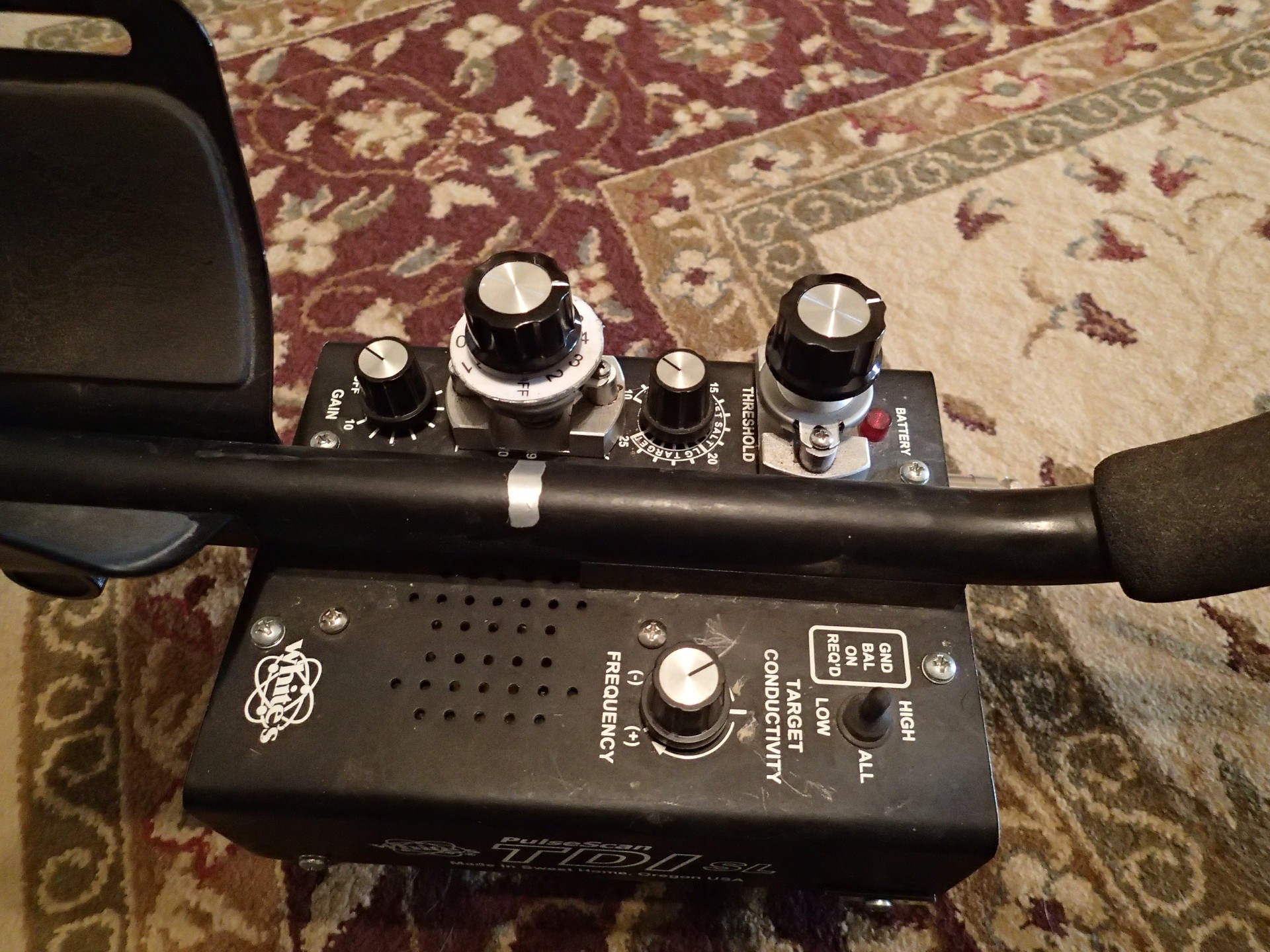
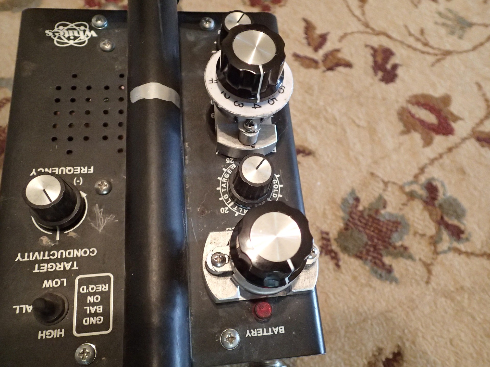
From what I've learned on Geotech, the 900 and 1200 are identical as far as circuits go. Both have a regulated power supply at 7.5 volts. The manual says the input voltage is 9v. My 1200 came with a 12v battery pack, but I changed it to 9v also. I was concerned the 12v may have been something the previous owner added. Both of my Discovery units are dual frequency, although I'm not sure if in "trace mode", without the Trace attachment, they still run at 73.5khz, or stay at the 12khz freq. I guess I need to check the power supply output voltage on my 1200 to see if it is a higher voltage than my 900. There's a lot of discussion about the nomenclature on the 800, 808, and with and without Cave mode. There was some legal action between Whites and Discovery over the TM808 with cave. That led to Whites dropping the Cave model. One Whites engineer told me the TM808 with cave was actually the TM800, and was a copy of the Discovery. I assumed Whites already had dropped the 800 nomenclature, but had a few of those models left and rebadged them as the TM808, but with Cave mode. I do know they're somewhat rare, so weren't made in large numbers, as was the later TM808 without Cave, which is, as I understand it, a different circuit. I appreciate the info, in any case.
Jim
-
Thanks, Chuck! I made an ugly, padded, waterproof case for this. The whole thing weighs about 25 lbs, I'm guessing. I'd tale $500, with the case. But, I'd rather trade. I'm going to wait a bit, and see what turns up. I'm really wanting a GB2 in good shape, But also like the Kruzer. I'll see what shows up first.😁
Jim
-

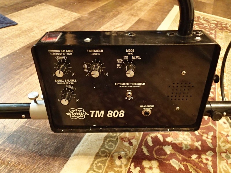 Good condition Whites TM808 with Cave mode. These are considered better than the TM808 without cave. They're called 808's, but the ones with Cave are actually the 800, which is a copy of the Treasure Finder 900 by Treasure Baron. Want to trade for a Gold Bug 2, or maybe a Gold Kruzer. The only reassom I'm trading is a I came into both a Treasure Baron 900, and 1200, and no longer need the TM808.
Jim
-
8 hours ago, phrunt said:
If you ever want to part with that 6x4" coil, give me a buzz 🙂
I've got a Razorback 3 1/4" x 6 1/4", Simon, and so far, I haven't been able to run with GB off. Granted, I haven't used it alot. I think our soil would be considered "moderate".
Jim
-
1
-
 1
1
-
-
Slightly off the subject, Steve....that display kinda reminds me of the DFX Signograph.
Jim
-
1
-
-
2 hours ago, GeoBill said:
About 30 years ago when I was doing some work more to the SW, there was active gold exploration in the Drum Mountain. In Millard County.
Found this Utah Geological Survey Open File Report in my files which might be of some help
Mines and Prospects Containing Gold in Utah
UGS OFR-207That's right, Bill. I'd forgotten about the Millard County. Had a buddy working at the mines around Millford, too. Mostly copper, but gold was produced, too. Though the OP asked about Box Elder county, this thread has morphed into all of Utah...LOL
Jim
-
1 hour ago, paradiceau said:
Jim and MSC, thank you both for your input, it is appreciated!
Keep us updated if you find anything worthwhile. Maybe between the 3 of us we can do some good.
Jim
-
1
-
1
-
-
- Popular Post
- Popular Post
Well people, I think I've finally accomplished what I set out to do 8 or 9 years ago. I think I've built at least a dozen different machines in an attempt to get something I could use to recover diamonds and indicator minerals without water. Maybe twice that many. The number of hours I've spent thinking about this are countless. I had an idea that my dry sluice might finally hold the key. I recovered a few tiny garnets with the larger model in Wyoming last summer. But, I still wasn't convinced. The riffles weren't quite right, and tiny gems are easier. Today, using the backpack model which only has a 7" x 24" sluice, but with the new riffle design, I put 8 1/4" alumina abrasive spheres in 3 gallons of mixed dirt/gravel. About 20% gravel, and 80% dirt/sand.silt. The alumina spheres have a specific gravity of 3.5. In most of the west the SG of the background material is about 2.5. I've never before managed to separate anything of less than 10, or a 1:4 ratio. All 8 stayed in the sluice. That, for me is a real accomplishment. I think the combination of that riffle, and the particular motion I designed into the sluice has finally overcome the "Granular Convection" problem. This is going to open up a lot of gem country, where previously I had to screen, classify, haul buckets of gravel to a water source, to use the Pleitz jig, etc. I'm a happy camper this afternoon. And, it should work even better on heavy metals. I'm going to apply for a Provisional Patent to start with.
Jim
-
11
-
The only place I know there is the old, I think it was called, the Texas Mining district in the old days. It had gold, but was mainly silver. It included the Vipont mine, which is privately owned, and they don't like trespassers. I've done considerable prospecting in and around the old PegLeg mine on the Idaho border..literally, right on the border, and just a short distance north of the Vipont. It was gold/silver. And this summer, about 5 miles north of there, a company from Nevada had a drilling operation going on, but after talking to them I got the feeling they were not finding the gold that the company that hired them hoped was there. The drilling crew kept pestering us about any gold we might have found. They wouldn't do that unless they weren't finding any. There currently, in the ICMJ magazine, is an old gold mine for sale north of Rosette, over at the base of the mountains. It was a fairly large operation. I think he was asking a couple of million. There's also a trommell setup on the south side of the hiway just east of Park Valley. I've always wondered if it was a gold operation. That area east of PV has a LOT of volcanics, and is not far from the Blackpine district in Idaho, which was a gold mining area. I think there also were some gold claims at what is now City of Rocks National Reserve, but no digging is now allowed. All this, of course, is in the western part of a very large county. I know nothing about the portion over towards Logan.
Jim
-
3
-
-
5 hours ago, Smithsgold said:
All very Good even Mine !!!! LOL Thanks Jim
AAhh heck, Jeff, anybody that doesn't enjoy you and Gary has no soul...LOL One of these days, I'd like to meet-up with you guys when you travel to Nevada. I'd invite you to Idaho, but our gold sucks...what there is of it...LOL
Jim
-
1
-
-
Really sorry to hear that. I appreciate the notice. That was quite a family, and they left a strong legacy.
Jim
-
3
-
1
-
-
For myself it's Two Toes, Chris Ralph, Smithsgold, and for sheer entertainment it's Colorado Gold Camp, amongst others.
Jim
-
2
-
-
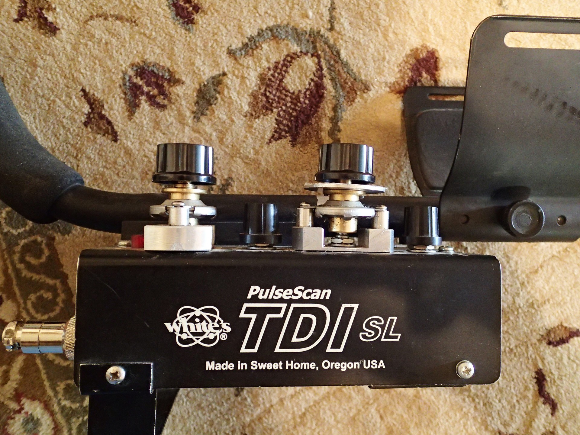
Yup...I've got vernier dials on both Threshold, and GB. But I liked a different control. I prefer the ones from Max Gain Systems. Mine are 6:1. I sold the kits for awhile. Still think I have one left somewhere in the mess...LOL


-
3
-

Well, Then There Was This…
in Detector Prospector Forum
Posted
Clark is a good man. I have personally benefited from his generosity. Not at all surprised to see him protecting that bird. I'm also sure a whole bunch of us guys would do the same.
Jim