Search the Community
Showing results for tags 'gps and mapping'.
-
 I've made an interactive 3D map of the Hoffman mining lease in Fairplay Colorado. There are two versions of the map A very LARGE one that runs about 30 Mb download and a much smaller one that's about 3.5 Mb. LARGE 3D Map small 3D Map The Hoffman lease is called the Katuska pit. It's about 8 acres of private property. It has been permitted as a sand and gravel operation by the State of Colorado since 1991 While you are viewing the map click on the "mine" area outlined in red. A window will pop up with links to information about the geology of the placers from the Land Matters Library and a link to the sand and gravel permit report from the State of Colorado. Use your mouse to move around the map. Scroll to move in and out or get dizzy by typing an "r" to make the map spin.
 -
another ---- question from me... Is there a "easy" way to move my google earth account from my old computer to my new computer. I would like to keep the waypoints I have...just because I like them... remember, small words and simple directions for fred... thanks fred
-
We all talk about gold and fault lines BUT how do you go about finding these fault lines exactly? They are not shown on Topo maps that I know of. What maps should I be looking to acquire? What do they look like in person? Sharply uplifted rock areas I am guessing? -Tom
-
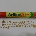
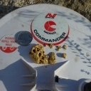
Hi Steve, I was going to inbox you this question but I thought others might be interested in the answer too. When we post pics on here are they automatically stripped of the gps info? I think I have read on another forum that they are but have tried to search the answer for here and nothing is coming up. Thanks, Northeast.
-
Made another 3D map, this time it's Barringer (Meteor) Crater in Northern Arizona. This is a small map, if you would like better resolution I have it but it will be a slow load on most connections. You can move around in the 3D environment with your mouse. Pan, Zoom and get Information from the features. Try typing in an "r" and watch the mountain spin in 3D. Type an "L" to turn on or off the labels. The "I" in the lower left corner will show you more options.
-
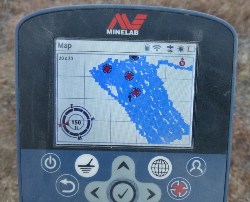
I've been working on a 3D mapping system. I've put together a sample map of Rich Hill, Arizona with some mine information. There is a bunch of stuff these maps can do but I'm not sure if they will work on enough peoples browsers to make it worthwhile to pursue development of this system. Please give it a try and tell me what you think. (Caution - this is about a 7 megabyte map and may take a while to load if you are on a slow connection) 3D map HERE. You can move around in the 3D environment with your mouse. Pan, Zoom and get Information from the mines. Try typing in an "r" and watch the mountain spin in 3D. Type an "l" to turn on or off the mine labels. It's a lot of fun and could be a cool feature for researchers if it works for enough people. This map is smoking fast on my development machine using the latest Firefox browser but doesn't work at all on my Safari browser. It works in Edge, Internet Explorer and Firefox on my Windows 10 computer but it's clunky. It doesn't work very well on my Windows XP machine in the latest Firefox. Give it a try and let me know if you like it or hate it. If it's working well for you might consider going to a bigger map version for more fun.
-
Are there maps of current active mining claims in Colorado that is updated and available to view????
-
 Just published at Minelab's Treasure Talk blog at http://www.minelab.com/usa/go-minelabbing/treasure-talk/gps-mapping-with-the-minelab-ctx-and-gpz-detectors-part-2
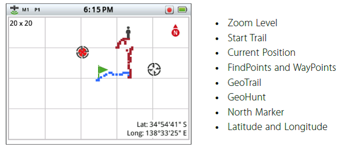
- 9 replies
-
- 2
-

-
- gps and mapping
- minelab ctx 3030
- (and 1 more)
-
Stumbled on this new mapping app. Lots of free maps to download. Seems to work well. Will report back to HQ when I use further. https://play.google.com/store/apps/details?id=com.Avenza
-
The first of a series of articles I am doing about the GPS system that comes with the Minelab CTX 3030 and GPZ 7000 has been posted on Minelab's Treasure Talk site
-
"Three years ago we introduced a cloud-free mosaic of the world in Google Earth. Today we’re rolling out an even more beautiful and seamless version, with fresh imagery from Landsat 8 satellite and new processing techniques for sharper images than ever before. Satellite images are often cloudy, but not always over the same place, so we looked at millions of images and took the clearest pixels to stitch together this cloud-free and seamless image. Landsat 8, which launched into orbit in 2013, is the newest sensor in the USGS/NASA Landsat Program—superior to its predecessors in many ways. Landsat 8 captures images with greater detail, truer colors, and at an unprecedented frequency—capturing twice as many images as Landsat 7 does every day. This new rendition of Earth uses the most recent data available -- mostly from Landsat 8 -- making it our freshest global mosaic to date." Details at https://maps.googleblog.com/2016/06/keeping-earth-up-to-date-and-looking.html
-
The other day I pulled up Google Earth as usual but now the navigation and zoom controls and the tool bar icons are very tiny. And now my placemark labels are larger than normal. I cannot figure out how to reset it back. Has anyone else experienced this?
-
Those of you who hunt are probably aware there are websites online where you can purchase landowner maps you can install on a hand held GPS which show who owns every piece of property in a given area, be it public land or private. Is there anything comparable to that for gold claims especially on public lands here in the US? Terry
-
Don't know if i am the only one who hadn't seen this video and AU information site---- but check it out---- It looks so simple that even Klunker could handle it!!!!!
-
Hi all, this is my first post as a newby. My wife and I are looking at upgrading detector equipment etc and I was wondering what others use for personal GPS tracking? Whenever we go 'bush' we each tend to 'work' apart and at times we lose sight of each other and also our start point. My concern is that we are risking getting lost (either together or individually) and if one of us only gets lost or is injured and incapacitated then the other one won't know where to find them. Do other forum members carry a personal GPS tracker each which shows your start point and has the capacity to track back to the beginning? Are there GPS trackers available that also can locate the position of a second GPS tracker, thus allowing you to find your partner? I imagine we would program each tracker ID into the other's GPS and it would not only show your own track but could identify the co-ordinates of the second unit. Does anything like this exist? We do each carry a small handheld UHF radio, which allows communication if in range (and conscious) but this is of small use if we are lost. I appreciate your replies and look forward to sharing this forum site with you all. Peter (down under)
-
Just wondering if there is any new information on LIDAR? Been wanting to use is to search forested areas. Here is a old link on the subject. http://www.detectorprospector.com/forum/topic/79-light-detection-and-ranging-lidar/?fromsearch=1
-
Hey all you mapping people--- i am having a hard time with my Back Country Navigator PRO Application (BN)---- I can't seem to find the layers i want such as- downloading the areas i am interested in with Public Land Survey System (PLSS) overlay???? What I expect a mapping program to be able to do is change layers ----- Like (Clay Diggings) Footprints -----or (Geocommunicator or whats left of it) LR2000--- I would like to see a program that has a library that holds all pertinent layers that prospectors would readily use accessible with a click, (this would be customizable by the individual ---- mines, adits, gravel pits, lode claims, placer claims, sections 1/4 section, roads, trails, lakes , creeks, intermittent wet areas, creek channels, old creek channels, benches, etc... Is it just me or is Google Earth becoming more user friendly for prospectors than BN (Back Country Navigator PRO)--- Maybe i need to spend more time with FP's (Footprints) ...and better learn the layers they have available--- And on the other hand i could just use the tracker I put in SS's (Sourdough Scott's) FIC (Fried Ice Cream) at (LDH) Los Dos Hermanos... carry on.... Edited for my pal Merton .....
-
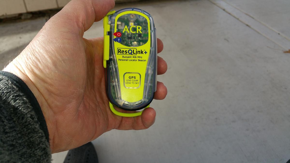
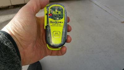
Thanks to Merton's persistence, I got this in the mail today. Very small, I should have had one years ago. ResQLink + Website https://goo.gl/photos/U1BU8KLGczQcHrCy8
-
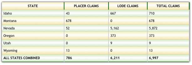
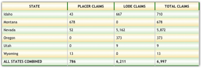
The Sage Grouse Proposed Mineral Withdrawal by the BLM would close nearly 10 million acres of land to mineral entry. This affects claims in 5 western states. Friday the 15th of January (this Friday!) is the deadline for comments on the proposal. Generally comments and opinions don't apply to the Secretary's decision but with the time near and facts on hand a little attention by more than a few voters and representatives might just convince the Secretary to think twice. If the withdrawal goes ahead no new claims can be made in the withdrawn area. In addition the existing claims are likely to come under greater scrutiny and challenges to their validity. That puts nearly 7,000 mining claims in the sights of the BLM land managers. Now is the most effective time to share your opinions and present facts to influence the outcome. With little time left the Secretary will have less chance to bring influence or political pressure to bear on members of Congress should they object. Land Matters has been working hard to figure out how many and which claims will be at stake should the withdrawal be approved. We've produced a comprehensive report on all the claims affected in this proposal and made an interactive map with just the claims within the proposed withdrawal area. The BLM did not assist in the preparation of this report. We spent considerable time and effort in hand mapping the location of these claims in relation to the proposed withdrawal. I could find no evidence the Secretary even knows how many or what claims would be affected. I'm sure she and your representatives would appreciate being informed of this information to help their decisions to be made on all the facts available. This is a factual report that you can not only view online but there is a zipped download available directly from the reports front page. At a mere 159Kb in size this report can be shared by email quite easily. Why not look over the whole situation and check in with your representatives to make sure they know the facts about the potential effects of this withdrawal should it be approved. The new custom interactive Sage Grouse Proposed Withdrawal Map shows just the claims affected with all the claim information normally found only on the Land Matters Mining Claims Maps. Be sure to read and download the interactive Sage Grouse Proposed Withdrawal Report too. To give you an idea of whats at stake with this withdrawal look over this summary chart from the report. Barry
-
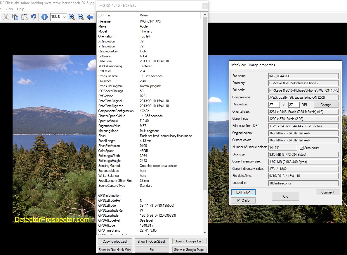
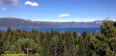
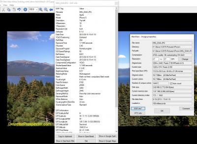
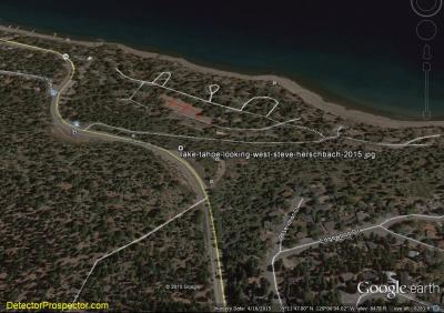
A topic got brought up at http://www.detectorprospector.com/forum/topic/1510-awesome-day-in-the-desert-sw/?p=17706 which is so important I wanted to cover it in detail on it's own thread. There is a feature in digital photography whereby information about the photo can be encoded directly into the photo itself. This originally was just information about the photo itself including the original file name and camera setting information, date taken, etc. There are two common formats you are likely to run into - EXIF and IPTC. EXIF tends to be technical details about the photo, and IPTC is more about copyright, description, and other details useful for publishing. Details on EXIF and IPTC here. When cameras equipped with GPS became a possibility, GPS information was added to the EXIF data. This was normally just something common to phones with GPS built in but more cameras are now coming with GPS built in and more GPS units are coming with cameras built in. Activities like geotagging and such make tying location data to a photo very popular. All those photos loaded up for viewing in Google Earth? Way easier if the location data is encoded into the photo. I use a great little free program called IrfanView which is amazingly powerful and compact. The IrfanView portable version can run off a USB stick. IrfanView has a photo information tab under Image in the menu which reveals all the EXIF and IPTC information, and allows the IPTC information to be modified. You can also set options for stripping EXIF data, both on image save or via batch processing. Like I said, very powerful little program. When you display the EXIF information in IrfanView, it offers to display the photo location in Google Maps, Google Earth, and some other mapping programs. Great for photos you took but can't remember where. OK, here is a photo I took on my phone, cropped, resized, modified the brightness, and added a caption. I saved as a renamed jpg but did not toggle the checkbox that strips EXIF data. I want to show that just because an image has been modified does not mean that data gets changed. Here is the image, and then a shot from IrfanView showing the EXIF data.... Now, you could save my lake image to your computer, and open it in IrfanView and view the EXIF data, but there is an easier way. Depending on your browser you need to get the address of the first photo I posted. If you use Chrome, just right click on the photo, and choose copy image address. Or you may have to click on the photo, choose the Save option, and copy the address out of the browser window. Bottom line depending on the browser you need to get the address where the image resides online. In this case the address for the lake image is http://www.detectorprospector.com/forum/uploads/monthly_01_2016/post-1-0-57762000-1451694506.jpg If you have copied that address (again, easy way is with Chrome) now go to this website http://www.verexif.com/en/ and where it says Or paste a picture URL paste in the address of the photo and hit return. A page will pop up with the basic EXIF information, and you will see a map at the bottom of the page showing you where I took that photo!!!! Notice the site has an option for stripping EXIF information from your own photos. It gets better. If you have an iPhone or similarly equipped device it even knows the direction you are pointing the camera, and this data is also encoded. If you did download my photo and open it in IrfanView you can load the location directly to Google Earth and see where I was and which direction I was pointing the camera. In Google Earth below as loaded from IrfanView the view was looking straight to the top of the screen capture which is rather obvious since I was taking a photo of the lake. The funny part is I named the photo "looking west" and now that I see where I was and the direction of photo it was looking east. OK, lessons learned. First, just use a camera without GPS, which is what I normally do. If you use a phone or other GPS enabled device, learn where to shut the EXIF GPS recording off or just turn off the GPS when taking photos. Even then I would use IrfanView to make sure you did it right. Possibly the most dangerous thing is uploading directly from a phone as it is too easy to forget and load up location data without thinking about it. Many sites like this one resize large images and EXIF information may get stripped in the process. In fact it is easier to lose the information than retain it if you do much with the image. It is not always bad stuff to have and keeping it can be a good thing - I purposefully use EXIF and IPTC information to help insure that people copying my photos without permission might be caught using the encoded data. It really is only the GPS location data that can be a problem given the nature of prospecting. But never count on the data getting stripped by a website, be sure it is not there in the first place if you do not wish it to be. We all really like photos, myself in particular, which is why I set this forum up with generous photo display options. I sure do not want to discourage people from posting photos - I want to encourage it. But do be careful when posting photos from a GPS enabled device to be sure you are not posting more information than you intended.
-
Really 2 topics here. I am interested in what kind of boots you folks use while detecting. I prefer metal free and currently use a pair of Keens but the sole is already starting to delaminate and they have less than 60 hours out and about. I know they are good about replacing them, or so I have heard, but I would really like something that will hold up reasonably well and won't give me that falsing that can happen when I forget about metal in boots. I ran into a Border Patrol agent who said he uses a boot called Vibram Rocky that has no metal and stands up to the terrain down here in Yuma by Sea (sorry Condor, I can't resist repeating your catch phrase). Comments or new ideas? 2nd question is about a standalone GPS unit that folks use. I have an old Etrex but would like something a little newer and if possible it will accept Google Earth images/KML files so I don't have to try to redo all the points I have saved to my places and the special MRDS and other KML layers I've accumulated. Any info is appreciated and I know from experience that somebody out there is bound to learn something from these topics besides myself. Thanks in advance.
-
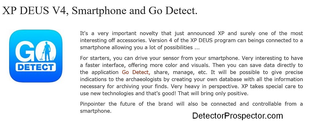
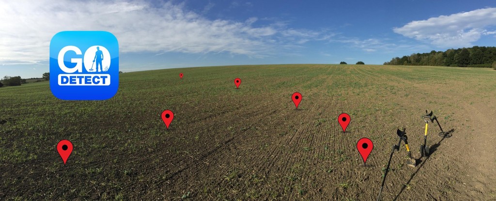
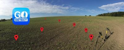
I started checking more into a mention of XP DEUS Version 4 updates, especially this badly translated information from a French website: So I started Googling and there is a Facebook page for the app at https://www.facebook.com/godetect/ Right now it is mainly just a finds recording and track mapping app much like the Minelab XChange system, but phone based. One photo really caught my eye however. It apparently can use the phone location services plus orientation features in combination with the app to superimpose past finds onto a view of the terrain. The prospecting applications for this alone are obvious. After my pretty much blowing them off last year XP is really getting my interest now.

-
This is something that used to be on individual gps apps, now it's coming to Google Maps as well; the ability to download specific maps and then seamlessly move from service to no service with no loss of navigation ability. Cool. http://techcrunch.com/2015/11/10/offline-navigation-comes-to-google-maps/
-
I am writing a series of tips and "how to" blogs on the zed GPS system. Sure it can be improved, but it is actually something I am finding it to be useful. There is something to be said for it being up front and in my face at all times that makes its use compelling. I like it.
-
Is it worth spending more money to get a GPS with a built in camera? Since I am not very good at marking waypoints and generally get confused on all the numerous GPS functions, I was wondering if the camera equipped units could record a photo of my current location and mark it for me automatically as a waypoint? Sure wish there was a GPS that only had basic functions, and a compass pointer and could still get me back to my car after a day in the woods and be water resistant and under $150? The camera units are upwards of $400-600 from Garmin, which is a bit steep for me. I never understood why GPS, cell phone, and digital camera and camcorder makers have to pack in hundreds of functions on their gizmos, which mostly confuse the users?