Search the Community
Showing results for tags 'gps and mapping'.
-
This is something that used to be on individual gps apps, now it's coming to Google Maps as well; the ability to download specific maps and then seamlessly move from service to no service with no loss of navigation ability. Cool. http://techcrunch.com/2015/11/10/offline-navigation-comes-to-google-maps/
-
I am writing a series of tips and "how to" blogs on the zed GPS system. Sure it can be improved, but it is actually something I am finding it to be useful. There is something to be said for it being up front and in my face at all times that makes its use compelling. I like it.
-
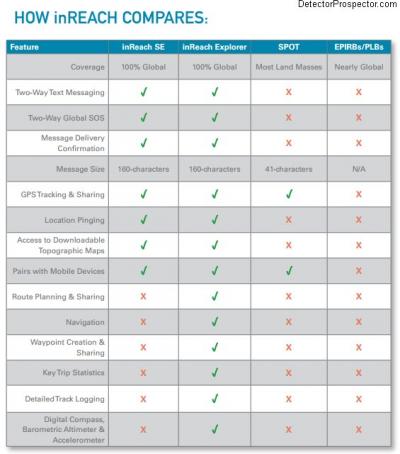
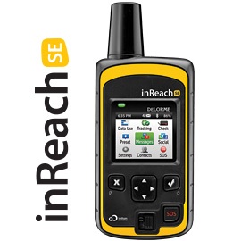
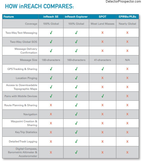
 Thanks to Dick Hammond for pointing this out. It is a reasonably inexpensive and effective alternative to the satellite phone. I have an Iridium phone I have used for years. It is the best insurance policy you can purchase for remote operations. But the phones are expensive, and the plans more so. Phones are around $800 now, but you can get used ones for about half that. It is the plans that add up. In Alaska we are lucky because a 6 month plan can be had for half what it costs for global minutes. Information on DeLorme InReach http://www.inreachdelorme.com/product-info/inreachse.php Cost for Iridium Sat Phone Plans http://www.satphonestore.com/airtime/iridium-airtime.html I may sell my Sat phone and get the InReach and have money left over. May be a better option for me now. Buy an InReach Communicator here.
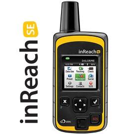
-
Is it worth spending more money to get a GPS with a built in camera? Since I am not very good at marking waypoints and generally get confused on all the numerous GPS functions, I was wondering if the camera equipped units could record a photo of my current location and mark it for me automatically as a waypoint? Sure wish there was a GPS that only had basic functions, and a compass pointer and could still get me back to my car after a day in the woods and be water resistant and under $150? The camera units are upwards of $400-600 from Garmin, which is a bit steep for me. I never understood why GPS, cell phone, and digital camera and camcorder makers have to pack in hundreds of functions on their gizmos, which mostly confuse the users?
-
Hey folks, you can now download Google Earth Pro for free. Used to cost $400. Lot of additional tools and features. http://www.google.com/earth/download/gep/agree.html Mike
-
Recently came across Maprika a free mapping program, versions for PC, Iphone & android, but what seems impressive about it is the mapping database it has for US, lot of old US maps for the relic and coin hunter. http://www.maprika.com/
-
Hi, I wonder if some of you that use moving maps programs could enlighten me how you use them in your day to day prospecting experience. I may be using a dual sport motorcycle/powered paraglider this summer was interested in learning how you incorporate moving maps with vehicles (or walking) Thx in advance, Paul
-
Welp, I reckon to sell a sack of nuggets for one of these magic wands. But, I'm cornfused. Does Minelab keep, share, sell, store, trade or do some fantastical wonders with my data? Can I fliparoo a switch to turn off the GPS? Can I fliparoo a switch to stop GPS transmissions? Heck, I just dunno, Maybe one of you do or we can call Scooby Doo!
-
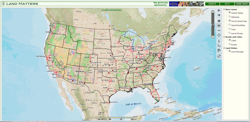
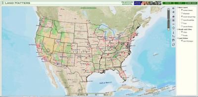
When Chris Ralph and I were down in Phoenix I was fortunate that Chris lined up a dinner with Barry and Leigh, the brilliant couple behind the new non-profit educational organization, Land Matters. The website at http://www.mylandmatters.org/ is your constantly expanding source of land related information, including: Library - A Library full of free maps, guides, books, tutorials and reference materials. Maps - Interactive maps for your area of interest. More being added every week. Articles - Factual articles written by those in the know. Information that you can rely on. Resources - Links and contacts to other communities of knowledge. Outreach - Programs that engage the community directly. Seminars, outings, trainings etc. I am far from done checking it all out myself, but this looks like something we should all consider getting on board with and supporting if possible. Check it out. I have added this banner to the rotating collection in the upper left corner: and added them to my links list Barry and Leigh, very nice meeting you, and keep up the great work! Here is a link to the new interactive land management status map http://www.mylandmatters.org/Maps/Management/GetMap

-
Howdy, Please see the following website http://apeoid.com/kmz-kml-padus/ for KMZ / KML overlays of public land for Google Earth. I have been using a paid subscription for years. This information looks to be accurate and well done. Thanks, Rick
-
I used to think those stories about people finding a vein or strike, then leaving, and then not being able to find it again later a strange story. I mean, how you could find something like that and then not be able to find it again. In my mind there would be no way I could forget how to find something like that. I would think I'd be able to go right back to it. Well, I can relate to the stories now. I was driving through a gold bearing area near me and saw an area I wanted to come back to with a metal detector. You know how it is when you have got the bug; geology takes on a new meaning. I'm always trying to identify what the ground is telling me. My wife gets bored with my amature geology convesation pretty quick sometimes as I start pointing out features as we drive along. To her its just rocks and dirt. To me its a story book. Anyway, we were driving up this road, natural on one side and cut on the other side, and I'm looking for areas in the road cut where the water worn rocks and gravel are resting on bed rock. It sounds easy enough but in reality it's not. Anyway I'm driving through a section of road cut rock and I notice a V in the rock from a old dry watercourse full of rounded gravel. Really caught my attention. A real X marks the spot type of moment. I mentally mark the area and determine to return with my metal detector at another time. I'm dreaming gold nuggets. That was in the early spring year before last. I went back about six weeks later certain that I coulc find the spot again, and guess what? I couldn't find it! To this day i haven't found it. I can see that V in the rock cut clearly in my mind but for the life of me I haven't been able to find it again. At least not yet. I think I have one more chance this year before the snow falls and prohibits travel on the road. If I don't find it on this trip then I'll have to wait for another spring to go searching for it again. Seems crazy that I can't find it. Just like it seems crazy for all those old stories. Anything like this every happen to anyone else? Drives me nuts just thinking about it. HH Mike .
-
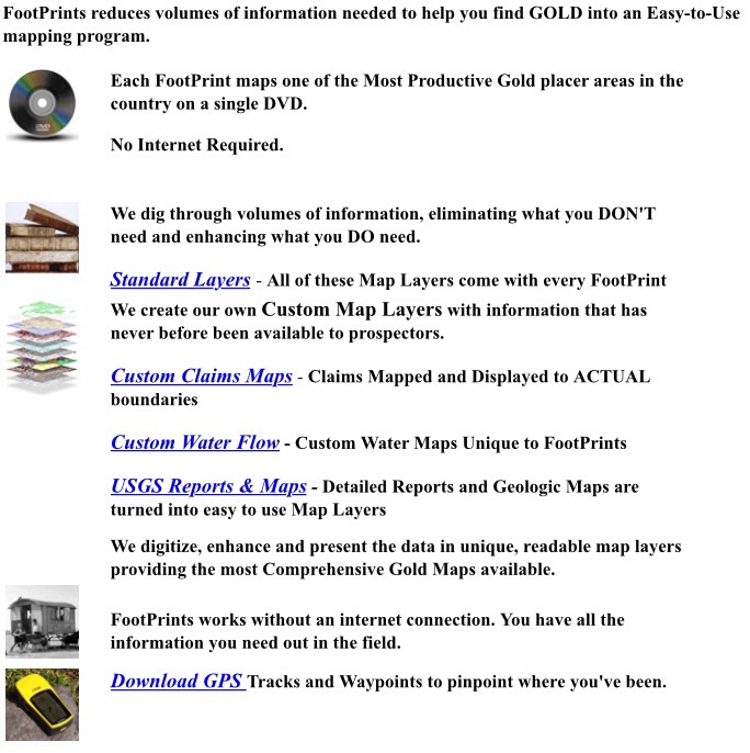
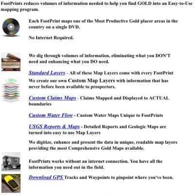
Last fall I ordered the North Fork American River edition of the FootPrints mapping software produced by Miner Diggins at http://www.minerdiggins.com/ I am far from expert with the software, but my stock in trade is research and I immediately saw the value in this series. In theory it is information I could find on my own for "free" but my time is valuable. Any shortcuts I can take when getting the information I need to go prospecting I am more than willing to invest in. I just ordered the Middle Fork American River, Gold Basin, North Bradshaws, East Bradshaws, and Black Canyon editions, all for less than the cost of a Minelab coil. The most valuable part for me is the current mining claims mapped to more than section level accuracy, which is all you get with other software. Not knocking the other guys - I subscribe to them also. There is a lot of additional value in geologic and historical map overlays. All in all, an excellent product well worth the investment. Now if Clay and Ruby can just get those other California editions completed and available, the sooner the better, I will add to my collection. Great stuff - I just love maps!
-
This looks interesting. An app for Android devices for tracking your detecting and recording finds. The possibilities for prospecting are really huge. Here's a post regarding the app. Link deleted since Findmall update broke all old links Here's a link to the Android Play Store for the app. https://play.google.com/store/apps/details?id=com.trib.app.tectotraklite The IOS version is a Kickstarter Project and I went ahead and pledged $5 hoping he gets it done - cause I don't have an Android phone.


.thumb.jpg.77e4cb5bf39d44bdd2050d2edb7dfdb1.jpg)