


Clay Diggins
-
Posts
429 -
Joined
-
Last visited
Content Type
Forums
Detector Prospector Home
Detector Database
Downloads
Posts posted by Clay Diggins
-
-
We've just updated the BLM LR2000 Claims maps. This update reflects the BLM claims status on February 16th, 2015.
We try to update this database about once a month. Please read the disclaimer. The BLM is not always accurate and never timely but these maps are still a good place to begin your research. You can look up the current status of any particular listed claim direct from the map interface and use the advanced search to find any combination of claim name, number or claimant right on the map.
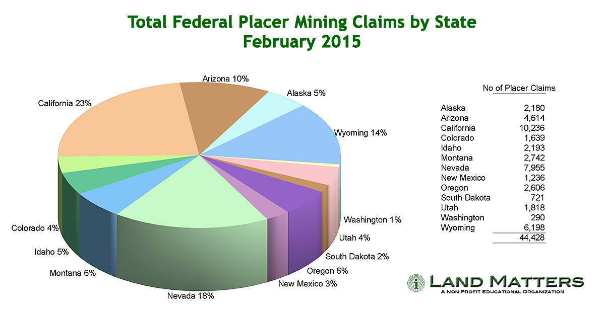
We try to give the most accurate and useful information possible on Land Matters. The current BLM LR2000 is not noted for accuracy but it is the source of some interesting information. Below are three current interpretations of the claims numbers that might give you a little different insight into the nature of claims in the public lands mining states.
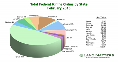
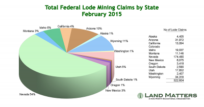

Interesting?
Barry
-
Wow! Land Matters sure has come a long way since these last posts.
As of today, just a little more than 5 months after launching, Land matters has had more than 1.3 million hits and served up more than 190 Gb of maps. files, videos and data.

Here's why Land Matters has become so popular so quick.
We now have Active BLM LR2000 mining claims maps for all the public land mining states. Those maps have a lot of information on each claim as well as direct live links to the BLM LR2000 serial page for each claim. The claims maps are now split into lode and placer claims for easier searching. Every claims map has land status and PLSS (Public Land Survey System) mapping available too.
We've also added the BLM and State claims mapping for Alaska. Those have additional information on each claim and boundary mapping as well as land status and PLSS mapping. As a bonus the Alaska claims maps also have an MTP (Master Title Plat) display layer.
You can now find and download any of the more than 265,000 current and historical topo maps on our new Topo Search Map. Just click the information button while zoomed in to your area of interest and then select from all the topo map versions for that area. A great historical research tool!
The Land Matters Library is growing by leaps and bounds too. We have recently added downloads for all 227 of the original Geologic Folios as well as 1,784 of the more recent Geologic Quads. You'll find everything there from the California MVUM (Motor Vehicle Use Maps) for the California Forests and the Gilpin County Colorado Mining District Records.
Don't pass by the Land Matters Tutorials section either. We are just getting started there but you will find tutorials and videos on how to determine land status including the LR2000 and the Master Title Plat systems.
Land Matters is just getting started. We've got 1,000s of documents to add to the Library and we have many many more interactive maps to add to the collection. Stay tuned there is a lot more to come!
Barry
-
I like the site Ray. Did you use a template or is it from scratch?
Google just recently changed the way their speed tool works so everybody gets a lower score now. I wouldn't worry about it - your page load speeds didn't change - just the "standards".
Optimizing your site to Google standards is fine if you want a fast site on an Android phone running Chrome browser. You will be chasing your tail for the foreseeable future though. The Google Kids like to change the standards every few weeks.
-
I like your attitude Steve. Life isn't always about being right or winning. Now this subject is getting into the realm of religion. Best to leave that and politics to others in my opinion.
I wish all the LRL users the best of luck. My belief is they will need that luck.

Now you have my opinion and my belief. With that and a $1.25 you can get a lukewarm styrofoam cup of coffee.

Heavy Pans
-
One of the more interesting uses of the GLO site patents records is to look up patents (private land) that may be blocking access to good hunting land beyond. If the patent survey shows public access through the patent the owners of the patent do not have exclusive use of the road. The public access is a part of the patent grant.
Court decisions in the past have ordered patent owners to provide public access. Usually this is done by ordering gates and obstacles to be removed but in some cases simply leaving the gate unlocked or allowing the passerby a key or lock combination will suffice.
Some of those old railroad patent blocks come to mind as a good study subject in that regard.
-
You will never get caught up Steve.
There are more than 5 million patents there and that's just the tip of the iceberg!

We spend a lot of time with the Land Status section. The Master Title Plats, Supplements and CDI index are the key to finding the status of any Federal managed lands.
It's truly a world beyond. A second home for some of us!
-
That two terabyte drive will fill up faster than you can believe Steve. It's the old house rule. Given ANY size house a man will eventually overfill it with stuff. Big house... lots of stuff.
Memory and storage have gotten a lot cheaper. That helps a lot.
Processing power not so much. To get that doubling of computer power for the next step something new is going to have to come around. The traditional chip isn't getting appreciably faster. We stack processors and memory pretty deep already but that only helps - it doesn't solve the problem.
With everyone going to phones and tablets for their day to day computer needs there isn't much incentive for chip makers to take big leaps to new technology. It's all about lower power consumption and less heat these days.
LIDAR will provide new insights into the world we live in. With stuff like retina screens and bigger brighter displays the consumers are there to enjoy those insights but the production is going to be slow and expensive for the foreseeable future.
-
Low resolution raw LIDAR data is publicly available for free for about 1/3 of the United States, mostly the east coast and developed areas. High resolution LIDAR (1-3 cm) is available in a few areas. Mostly for environmental studies or only available privately.
Without LIDAR we have to rely on DEMs (Digital Elevation Models) for elevation data. These are mostly just a rehash of the old paper topo maps with hand drawn elevation lines converted into even lower resolution digital point shapes represented by light and dark shades on an artificial black and white image. The shades of gray of each pixel represent different elevation values. These DEMs have a high factor of human input error. Mountains and valleys sometimes appear wher there is nothing but a road or a visually confusing feature on the original topo map. If I were to describe the conversion method for these topo's derived DEMs I'm sure you would be in awe of the influence of primitive technology in our "modern" lives.
LIDAR is really just a (sometimes) higher resolution version of this system with the difference being the LIDAR points are defined by direct reflection of a laser light rather than ground observations with optical equipment, geometry and trigonometry - traditional survey equipment and methods. The final result in either case is still a grid of values most usually visualized and stored as a photo image in shades of gray. Although just about any data storage format will work humans still naturally understand complex data with their eyes better than any other sense.
The features you see on your link were buried in the original LIDAR data. A lot of post processing (number crunching) is necessary to turn the raw data into detail like you see on the website linked. In other words the LIDAR system itself is not discriminating out the trees and ground cover. That is done by applying some pretty complex algorithms to the data after the fact. All of that processing actually lowers resolution and accuracy. To be truly effective for any particular purpose those algorithms are usually customized to the project requirements.
We use LIDAR on some of our private mapping projects along with matching high resolution georectified aerial imagery. This can reveal several features you could never see from the ground or the air. We can build 3D models that very closely conform to reality and move through those models in three dimensions. This is a very realistic process and allows us to include measured, extrapolated or even sensed data for underground features. Mining companies love this stuff, not so much for project management but for making presentations for investors.
The size of the data involved is a very real problem. Terabytes of data are needed for even a small area and processes take a very long time to run on data that size.
Just obtaining the data can be a very long process. We can order a LIDAR scan of just about anywhere in the world but the logistics of producing that scan can be overwhelming. A good high quality scan requires several manned precisely located ground stations as well as some very expensive aerial equipment. Just getting the time booked can be a long wait and getting the skilled ground and air crews working together under ideal conditions can be a virtual impossibility. Add in the difficulty and expense of placing those ground crews on landlocked parcels, hostile territory, difficult terrain or legally challenged access can make the entire process prohibitively expensive and slow.
Like much of what is possible in theory the theoretical 1 cm accuracy of a LIDAR scan is rarely if ever achieved in real life.
This is not a new technology, it's been around since the 1960's, but until now the technology to push it into the realm of useful and affordable has been lacking. That is changing and I look forward to a time when high resolution ground scans can be considered an accessible tool for many professions. Until then it is a gas to work with small areas in high definition, I only wish more clients could afford the time and money involved in high resolution LIDAR.
-
How about the Mokolumne dranaige or s. fork Stanislaus then.
Now you're talking my language Ray! Thanks for the input. Those two along with the Merced are my old stomping grounds so I'm looking forward to seeing those myself. Lot of stuff has changed there since the '70s!
Barry
-
Clay, Do you have any idea when the S. Fork of the American will be available?
Hi Steve,
Thanks for the input. The South Fork isn't much requested yet so it's probably more than a year away. I heard there's no gold there?

Right now the North Fork of the Yuba and Rye Patch are the top contenders. Enough people calling for the South Fork before January could change all that though.

I sure would like to see the entire American basin "snapped" together. Hmmm
Barry
-
Hi Clay,
I was getting ready to order my new editions when I saw you had signed up on the forum so it was all serendipity at work. I am registered - do I need to register each edition? Also, will adjacent Bradshaw editions also "snap" together?
Really great product. The real secret to success is putting yourself in good locations and research tools like FootPrints make that happen. Thanks to you and Ruby for your efforts.
Hi Steve,
A very generous sense of serendipity you've got! Thanks again.
You will need to register each FootPrint to get the claims updates. Software updates, like mapping improvements and tools are available to all FootPrints users without registration but the claims updates are reserved for registered users.
Unlike other software we don't know who you are or which FootPrint you have installed. Our software doesn't "phone home" and we have no way of knowing which maps you are using or when you are using them. We don't like snoops and in our business privacy is essential. Each FootPrint user is entirely in control of what is installed on their computer for FootPrints. The registration information is only used to contact you about updates. Your information is never shared.
I do have a working "snap" tool for the Bradshaws FootPrints but it needs more testing before it's ready for download. We are concentrating on claims updates right now along with some useful program upgrades. The Bradshaws "snap" is nearer to the end of that schedule than the beginning. I'm hoping we can get that tool along with all the updates and upgrades ready for users before the end of the year. We should begin rolling out those updates next week.
Barry
-
The California FootPrints are being done by drainage basin. Pick a river drainage and I'll have a better idea of the area you are interested in deathray. I should have an interactive map with all the existing and proposed FootPrints boundaries up on the website soon.
Please realize on a 4.7 Gb DVD we can only fit a little over 200 square miles. Any larger and we get into multiple disks for installing and a much longer production time.
To give you an idea of why these FootPrints take so long to make, the total data used to create that 200+ square mile map is more than 1.2 Terabytes. We smash smoosh and trim everywhere we can to get that down to about 12 Gb and then do several steps of compression magic to get it onto a DVD and your computer.
Make sure and register your FootPrints Steve. There are updates for the software that are available for free to all FootPrints users but the claims updates only go out to registered users. We've got a nifty update that will "snap" your North Fork and Middle Fork maps together so you can use them as one.
-
What a nice greeting!
I signed up here on Steve's forum last Friday night and left for the weekend. I hadn't had a break in the last month so the better half and I took some private time this weekend. I thought I was coming home to endless work and find this wonderful surprise.
Thanks everybody for the comments. I love it when FootPrints users "get it". I wasn't aware Steve Herschbach was using the software or even knew about it. It's gratifying to know that a prospector of Steve's caliber sees value in what we do with FootPrints.
Looking around this thread alone I see some very experienced miners. I'm obviously in quality company here, it's particularly nice to be welcomed by such a great group of people.
I honestly don't know why it took me so long to sign up here. I hope I can contribute here, I'm not much of a detectorist but I do have a few other useful skills and a nice #2 shovel.
We've been preparing claims updates on the 11 available FootPrints. Those will start rolling out this week along with several user requested program upgrades. The BLM has been really dragging their feet the last two years on updating their claims case records but the last few months they have finally started to catch up so these updates might give you a reasonable idea of what's really happening in your FootPrint area.
Many more FootPrints are planned. It takes about five months for the two of us working 70 hour weeks to finish a new FootPrint so they are always going to be slow in coming out. Add in the commercial jobs for mining companies that actually pay the bills and about two new FootPrints a year is all we can handle.
We hope to start the next FootPrint in January. Which area that will be is up to user input. Right now the Yuba is the most requested with Rye Patch coming in second. That can change before January so don't be afraid to let us know what you want - you just might get it.

Thanks again everyone, it feels good to be here.
Barry


Proposed Changes To Mining Law In 2016
in Gold Panning, Sluicing, Dredging, Drywashing, Etc
Posted
This same BLM budget proposal comes around every two years. If you understand the strength of the mining lobby you understand why this is a no starter.
Just yesterday I was reviewing an OMB audit of the mining claims fees from 2001 and lo and behold they included reference to this same BLM proposal exactly. Near as I can tell it was originally written during Carter's time in the late 1970's.
Some congresscritters keep this around as a bargaining chip come budget time. It will never pass committee but it makes certain congressmen appear as if they deserve greenie votes - and funding.
The OMB audit was much more interesting than this proposal.
Barry