

Steve Herschbach
-
Posts
19,755 -
Joined
Content Type
Forums
Detector Prospector Home
Detector Database
Downloads
Posts posted by Steve Herschbach
-
-
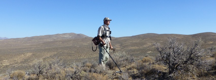
I am not particularly interested in the very popular areas and am slowly extending my reach into less traveled areas as I get my bearings.
Having been to Oz I consider it much easier for me to find gold closer to home here in the U.S.
-
Wow, very nice nugget!!
-
Not to rain on the parade but if the ground is anything more than mild you will see almost no depth gain and in extreme ground you will actually lose depth going that large with a hot VLF. At least that is my experience. I hope you do better.
-
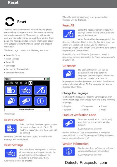
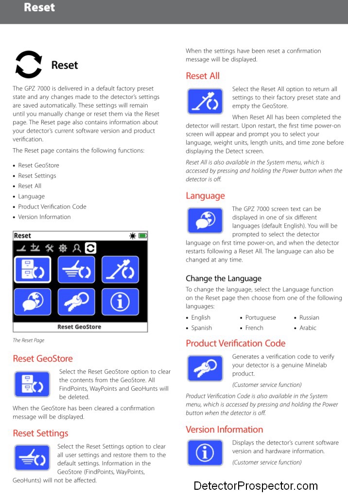
So if you turn off the machine at lunch time then want to resume afterwards, you're starting another Geo trail and have now used up 2 of the 10?
No, there is not a limit on number of tracks, there is a limit on total memory used by way GPS data stored.
-
Yes, if you use Bootcamp, or in my case Parallels. There is no native Mac app.
-
More space would be good but if you ever had that detector stolen you would lose it all (but still agree more space is better). I dumped my data to XChange every couple days. Once copied from the GPZ you can delete all the data or portions of the data on the GPZ from XChange with a single command. If you do it from the GPZ it is manually one at a time unless you do a Reset Geostore.
You do not have to be online and logged in to move data from the detector to XChange. The only reason to be online or logged in is to see the data overlaid on Google Maps. I used XChange while in the middle of nowhere and no internet to dump data for storage. If doing this you have to manually keep a list of what each track name means as far as general location or wait until you have an Internet connection to map it. This is one reason why an export function is so critically needed. We need to be able to export to other programs that have offline mapping capability, or XChange needs a redesign to work with downloaded maps. Export would be far preferred by everyone with existing data from other sources and working systems already in place.
-
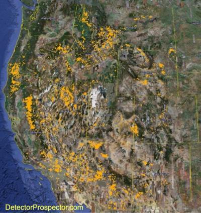
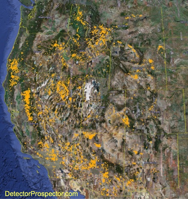
It really is a very generalized map that encloses regions made up of both producing and non-producing areas. The area in Alaska and Canada shown as productive would look more like Swiss cheese if it was more detailed.
Access in Canada and Alaska is often only by small aircraft at best. The western U.S. is far more accessible but that last few miles can be a real killer. The entire thing is a patchwork of private and government lands, and the government lands very often are covered with mining claims.
I found living in Alaska that access was 100 times more difficult than what I am experiencing in the Lower 48 states. Nearly everything in Alaska is claimed and so you need a combination of air access and a deal with the claim owner to get anything done. Canada is similar.
Whereas here in the western U.S. I figure I already have enough areas of interest to last me the rest of my life. They may or may not pay off but there is plenty of ground for me to go detect. The main issue is getting the land research process figured out but once that is done potential areas abound.
Here is a map of gold claims in the western U.S. which mirrors the gold producing areas:
-
-
The higher the frequency the "hotter" a single frequency detector is to small gold but the more likely it is to sound off on wet salt sand. On dry sand you can use most anything but wet sand calls for lower frequency detectors, generally 15 kHz and lower. Even then most 13-15 kHz machines struggle in wet sand and therefore have salt or beach modes that define the machines to deal with the situation as it occurs.
-
I absolutely share your concerns and want Minelab to improve the system, most importantly by offering a straight forward export function. The system should work for EVERYONE not just those who are not as worried about the security issue. From a functionality aspect I would much prefer to export to my already existing Garmin database/software.
It should be easy and I expect it will happen at some point. So I thank everyone for reinforcing the need for changes in the system.
But I am still going to just ignore all that and try and help those who are interested with a few tricks I have learned. I might even have a surprise or two for those who do have security issues. The system has functionality that does not have security risks.
-
Thank you AjR and everyone else.
-
Norvic, I get it. I have built and administered large computer networks and done a fair amount of programming. I get it. My options are:
1. Tell people to just leave the damn thing turned off
2. Explain to people who regardless of the issues you have brought up how the system might be used to advantage
The problem as I see it is the very mention of the system always does just what it did here. It devolves into a discussion over security.
I understand your concerns. Can you also understand that I am using the system, and if you or anyone else wants to have a go at hacking Minelab to find out where I am detecting, that I just do not care? The number of people who prospect with detectors and who also happen to be world class hackers and who also have direct physical access to the areas I have access to is so vanishingly small as to be non-existent. If they did exist, with enough effort they might discover exactly where I am detecting. Frankly, that information would do them little good. Not everyone is detecting the kind of high value ground that demands the levels of security you are demanding.
-
I 100% agree Norvic and I am certainly passing my thoughts on those issues to the powers that be. There is a lot that could be done differently with the GPZ. Not only could it be done by Minelab, but by anyone with basic programming skills. Regardless of all that though, my goal is to work with what is and to try and help those who also interested in using what is.
As far as security goes my understanding is the location data is not passed to Minelab and there is nothing on their server to hack in that regard. The GPZ Instruction Manual includes the following privacy declaration by Minelab (at page 35):
To protect the privacy of your GPS and GeoStore data:
• GPS is ‘Off by default.
• GPS and GeoStore data is only ever stored locally on your detector and locally on your PC (if transferred using XChange 2).
• The detector does NOT transmit GPS or GeoStore data wirelessly.
• GPS and GeoStore data is NOT transmitted to Minelab from your detector or PC.
• Your data is NOT accessible by others via the internet and NOT stored online (cloud storage).
-
Yeah looks like a spammer.
Be interesting to see what you think of the zed argyle. I think hardcore VLF operators have an edge running it.
-
Hi joe,
Welcome to the forum. I have never used any other Nokta detectors other than the Fors models and know next to nothing about them. Sorry.
-
Previous forum thread on dry washers http://www.detectorprospector.com/forum/topic/28-drywashers/
-
Minelab has stated multiple times that they are not interested in and do not access the data. It remains either on the GPZ or on the computer you use. Some people simply choose not to believe that. I have decided therefor to not spend much time trying to change paranoid minds but I do have a few good ideas for those that are. But again, that will be another series of posts soon.
-
Oops stupid fat fingers! Fixed that thanks Argyle
-
I am writing a series of tips and "how to" blogs on the zed GPS system. Sure it can be improved, but it is actually something I am finding it to be useful. There is something to be said for it being up front and in my face at all times that makes its use compelling. I like it.
-
Whoa folks! Posting on multiple forums is not a crime. We have a new member, let's give the benefit of the doubt before making assumptions. Hopefully Cindy is legit and if so she is welcome here. If not.... I will handle it. Thanks!
-
I do not want to collect money or any such thing. Not a bad idea at all, just more than I want to get involved in at the moment. I am up to my neck in alligators, so to speak, at this point in time.
People with really great stories they think might be worth a buck should consider submitting them for publication in the ICMJ Mining & Prospecting Journal. Scott and Chris ALWAYS need articles.
-
Well, I guess I am not sure what you mean. You want to run a competition and offer some sort of prize?
-
There are no small concentric coils for the Goldmaster series. Well, excepting a prototype I had but sold some time ago.
The coils made for the White's Goldmaster/GMT series are pictured at http://www.detectorprospector.com/gold-prospecting-equipment/whites-electronics-gmt-metal-detector.htm
-
In my case none. The battery gets me through a long day GPS off or GPS always on. I never turn the GPS off now.Great post, nice pictures
How much detecting time will you lose, if using the the GPS full time?
Fisher Goldstrike
in First Texas - Bounty Hunter, Fisher & Teknetics
Posted
I am not pro any brand. I believe brand name loyalty is a liability.
You have a couple great machines Fletch - welcome to the forum!