HardPack
-
Posts
607 -
Joined
-
Last visited
Content Type
Forums
Detector Prospector Home
Detector Database
Downloads
Everything posted by HardPack
-
What Type Of Workings Is This?
HardPack replied to Lead Detector's topic in Detector Prospector Forum
I agree. Traced up from a stream bottom only to find the larger gold located on false bedrock five feet above the actual bedrock and 25 feet above the stream channel. Looking upslope to the north across the stream channel you could see where the hillside slumped (escarpment) then slid down damming the stream. The stream eventually cut through the blockage leaving the gold perched on the bench. The hills were probably closer to the subtropics when this mass wasting event occurred and it took me just about as long to figure it out. -
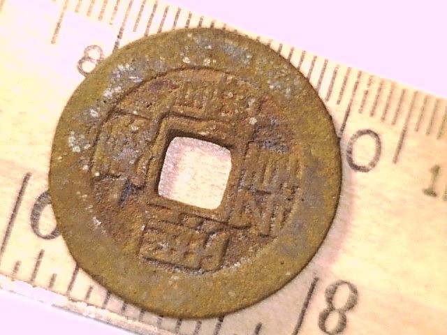
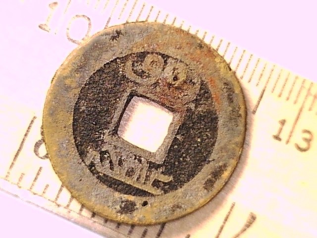
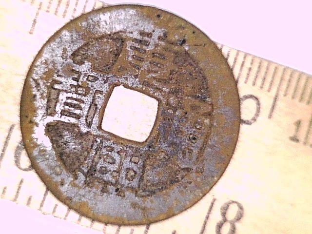
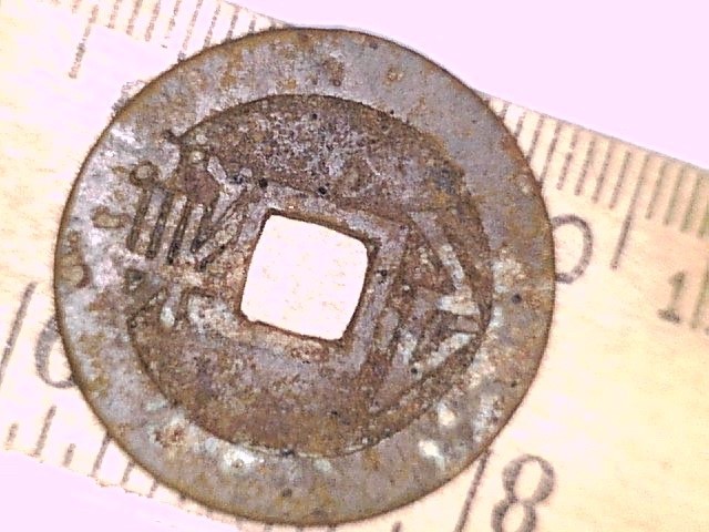
From the web: How to ID Chinese cash coins. First read the symbol at the “top” of coin then combine with the “bottom” symbol for Period: Dynasty/ Emperor. Second read the symbol on the “right” of the coin then combine with the symbol on the “left” for currency* *The “bao” symbol is the usually on the “left” meaning currency, the right symbol will be either Universal, Original or Heavy. Use the web Chinese cash coin “photos” to determine top from bottom, front from back. side note: A 1850’s $10 gold coin was dug up by a local utility worker in the Old Chinese section in town that is now a parking lot. You never know what may turn up in the next scoop. It could be copper, it could be silver, it could be gold.
-
What Type Of Workings Is This?
HardPack replied to Lead Detector's topic in Detector Prospector Forum
I may of spotted a “gold crown” in the throat of the core but it appeared to have a high silver content so didn’t bother to point it out. Get yourself copies of the following books. You may be a rich man but just haven’t discovered it yet. “Roadside Geology of Nevada”. The book has sections on NV 227 Elko out Lamoille Canyon, NV 225 Elko up to the Idaho Border, NV 378 Carlin to Eureka and my favorite Pahrump Road. The intro to Nevada covers basic Nevada geology, rocks, minerals and mining. Only $26 on Amazon. Jim Straight’s “Advanced Prospecting & Detecting for Hardrock Gold” covers the types of hydrothermal ore deposits, “supergene enrichment”, hydrothermal alteration, meteorites, etc. -
What Type Of Workings Is This?
HardPack replied to Lead Detector's topic in Detector Prospector Forum
Keep us posted. The rock does appear to be limestone or dolomite altered by hydrothermal fluids. They may have of dozed the flat for a coring rig. If there’s a rock shop near you could pick up a test kit: “placing a drop of dilute (5% to 10%) hydrochloric acid on a rock or mineral and watching for bubbles of carbon dioxide gas to be released. The bubbles signal the presence of carbonate minerals (limestone & dolomite).” -
One had a rolled piece of beveled metal inserted in the square hole; for stacking the coins? From what I read the Chinese would string the coins up a thousand 1-wen pieces. Apparently the string would often break during placering operations.
-
I believe this Chinese cash coin to be a Qianlong Tongbao minted 1735 to 1796 for the 5th Emperor of the Qian Dynasty. The currency symbols were different for Universal, Original & Heavy. this
-
I am not an expert on Chinese cash coins but I will give it a shot. Feel free to correct me. Apparently, the Chinese miners in the goldfields traded for supplies with Chinese merchants using a variety of Chinese cash coins; 1-wen, 10-wen, 1000-wen. I beleive 1,000 wen equal an ounce of silver. This coin may be either copper or bronze. I think this coin is a Kangxi Tongboa 1-wen minted from 1661-1722 during for the rule of the 3rd Emperor of the Qing Dynasty, Kangxi; I have no idea what the symbol on this side mean.
-
Floods Of Gold
HardPack replied to HardPack's topic in Gold Panning, Sluicing, Dredging, Drywashing, Etc
If interested here’s a link to the New 49ers Mining group in Happy Camp. They have the majority of mining claims in the area. A $100 buys you a week (7 days) of claim access during the summer months. It is cheap way to explore the Klamath. They also have a mining supply store with fresh water in Happy Camp. https://goldgold.com/ On the website there is a quick link menu on the left, Hit the “What’s New” to view the latest newsletter, there is also a list of claims by area, Facebook link, RV camping, etc. The old timers hydraulic the benches in both sides of the Klamath. As a result the gravel bars are deep but there are pits, tail-outs, tailing piles & jade. At one time there was a pack trail from the port at Crescent City to Fort Jones. If you are in the area stop by the 49er store for Information, the staff has mined and detected the area. -
Good luck
-
Which metal detector did you take? Seriously, I assume depending on ground mineralization either a VLF or PI but what other criteria would be recommended if a person was considering detecting for meteorites?
-
Floods Of Gold
HardPack replied to HardPack's topic in Gold Panning, Sluicing, Dredging, Drywashing, Etc
Along Highway 96 a 1/2 mile south of Cottage Grove at Elliot Creek there is a short road on the river side. At the end of this road on the right is a dirt road that will take you to a river bar. USFS Dillon Creek Campground is 2 1/2 mile on the west side of Hwy 96. In Happy Camp there a grocery store, a card lock for fuel and USFS Curly Jack Campground. Some folks camp at Windgate Bar between Happy Camp & Cottage Grove. In the summer months the road along Indian Creek between Hwy 199 to Hwy 96 at Happy Camp is open. Great area -
What Type Of Workings Is This?
HardPack replied to Lead Detector's topic in Detector Prospector Forum
Some of the smaller rock piles appear to be hand stacked. It may have been a sample site explaining the coring. Check Land Matters for not only current claims but historic claims. -
Floods Of Gold
HardPack replied to HardPack's topic in Gold Panning, Sluicing, Dredging, Drywashing, Etc
Here’s a word of caution based on personal experiences when venturing into the Klamath and Salmon rivers as a prospector or miner of gold. The 1884 Sawyer Decision did not apply to the California North Coast rivers. As a result hydraulic mining continued on the Trinity, Klamath and Salmon rivers. The Karuk ancestral tribal lands extend up the Klamath river from the Bluff Creek confluence including Happy Camp then up through Siskiyou County. The Yurok ancestral tribal land extend down river to the mouth of the Klamath and along the Pacific coast. The Hupa ancestral tribal lands extent up the Trinity River through the Hoopa Valley from the confluence with the Klamath River. The impact of hydraulic mining in these watersheds has not placed miners (old or new) in the favor of these North Coast tribes. There have been occasions in the darkness of night relocating a campsite was a good move. They are good and generous people but they place a high value on their way of life. This is not a tall tale, be respectful, be careful and be aware of your surroundings. An amazing place to explore and fish. -
Floods Of Gold
HardPack replied to HardPack's topic in Gold Panning, Sluicing, Dredging, Drywashing, Etc
I am not talking Cottage Grove, Oregon. I admit being from a family of the South I may take liberty to make a story entertaining. However, it was their story and like you I originated a skeptic from Oregon. The location is on Highway 96 between Clear Creek and Somes Bar. The Klamath River mining claim is K-25B Cottage Grove (mylandmatters.org). Check it out for yourself, wonderful country. Here are the GPS coordinates for the Klamath Cottage Grove: N41* 36.156’ W123* 30.335’ Cottage Grove isn’t much more than a cottage. There is a summer camp of sorts to the NE on the river. Here are the GPS coordinates for the old cabin flat: N41* 35.890’ W123* 30.522 Here is the approximate GPS coordinates for the freezer box tree: N41* 34.605’ W123* 32.453’ Sorry the locals kept the nickel since at the time I did not own a waterproof detector. Here’s a recent web photo of the South Yuba River at flood stage (not mine).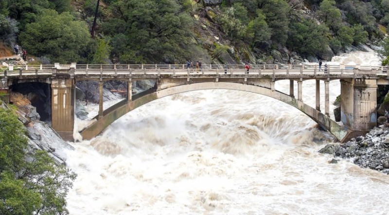
-
A few years back while working on a “S” bend of the Klamath River immediately south of Cottage Grove, two locals related their experiences during the “Christmas Floods of 1964”. We were all standing along an outside bend looking up at an old freezer box hung up in a tree a hundred feet above the summer flows. The day before across the river a 1964 nickel had been detected on an old cabin flat, the cabin being long gone. According to their stories, cutoff and isolated upstream near Happy Camp at the confluence with Indian Creek, the flood flows were pushing giant boulders down the river channel. They both stated you could hear the boulders gridding against the river channel bedrock over the roar of the flood waters, the ground was vibrating. Later it was estimated 24 inches of river channel bedrock was grounded away during the 1964/65 floods. At the time (of the stories) I was ferrying “play” dirt across the river from another outside bend down stream of the freezer below the tail-out of an old upslope gold operation. The gold was deposited thin sheeted (gold leaf thin) in the cracks of the bedrock above the summer water level. The “Great Flood of 1862” and the “New Years Flood of 1997” no doubt grounded loose floods of gold trapped deep in the channel bedrock cracks and cervices of many a river beds in both the Klamath and Sierra Nevada mountain ranges…. Only to find a deeper deposition crack beyond the depth of reach. It took days to pan the leaf gold from the coarse sands which is directly responsible for a downfall into detector addiction. This is not a call for help.
-
Sierra Snow
HardPack replied to HardPack's topic in Gold Panning, Sluicing, Dredging, Drywashing, Etc
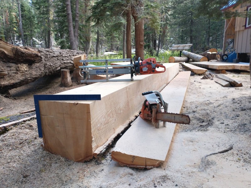
High winds, low elevation snows, flooding… winter is inbound today. High winds with a low snow pack can result in uprooted trees. Here are the results of the January 19th, 2021 winter storm with 90 mph winds combined with a low snow pack. The photo was taken the following Spring while pulling the tree off the cookhouse roof. . There are more down trees hidden in the center shadow of the photo. Two of the trees were actually leaning into the wind. Fortunately, only minor damage to the roof. Spent the summer milling lumber instead of prospecting & detecting.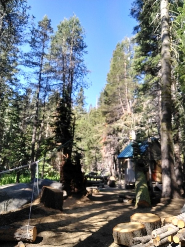
-
Lg24 Coil How Well Do You Like It??
HardPack replied to bigtim1973's topic in Nokta / Makro Legend Forum
Last couple of days used the LG24 on a 1850’s placer site with a hydroelectric and an overhead high voltage transmission line within view. The iron trash caps the site requiring periodic raking down through the layers then running a magnet through the loose dirt to pick out the square nails, boot tacks and small pieces of rusted tin. This process was repeated until iron masking was reduced enough to allow the detector & coil to pick out the non ferrous targets Set the sensitivity between 25 & 30 experienced no real problems with EMI while detecting. Some EMI chatter at 28 & 30 when the detector was set down and not in motion. Detection depth offset by raking so was not measured. The center of the coil is the sweet spot. Updated the Legend software to v1.13, used search modes Park 1 M1 & Goldfield M both at factory setting to start. Adjusted recovery as high as 8 with IF 4; GB 45. Good Coil, especially for “cash coins”. -
Sierra Snow
HardPack replied to HardPack's topic in Gold Panning, Sluicing, Dredging, Drywashing, Etc
In 1841 the Bidwell-Bartleson Party passed through the mountains pictured in the photo to the south headed for the Marsh Ranch near Mount Diablo. Their route is estimated to be just south of the near ridge pictured in the photo. At that point they were down to pack horses and low on supplies including food. When the party came to a point where they could view the California coastal mountain range they actually thought the far off mountains were the Sierra Nevada. Fortunately, near the San Joaquin River the party was found then guided to the Marsh Ranch. When discovered along the river the Miwok had taken and eaten their remaining pack horses. The party’s supplies were exhausted and they were reduced to sharing a coyote. John Bidwell would be employed by Sutter at the Russian fur trading Fort Ross. Bidwell would be elected a California State Senator. His mansion located in Chico is open for public tours. Another party member was Nancy Kelsey who carried her baby as she walked across these mountains. Kelseyville near Clear Lake, Lake County is named for her family. Her crossing is still celebrated in the mountains. The Donner Party attempted a late Sierra crossing further to the north of Lake Tahoe. One of the survivors would marry and settle down with John App, of Apps quartz mine. Their home is located near Woods Crossing, the Tuolumne County gold discovery location west of Jamestown. The roof of their home recently burned. Neither of these emigrant parties were the first to cross the Sierra. They were only the first to have survived the crossing that could write. A lot of snow, a lot of steps, a lot of gold and a lot of history. -
Shoot! Nothing was shot out from the “Shot Show”. The next big event is Garrett’s 60th anniversary celebration with the issuance of another patch on April Fools’ Day.
-
Sierra Snow
HardPack replied to HardPack's topic in Gold Panning, Sluicing, Dredging, Drywashing, Etc
…then to concentrate in my pan. Many a prospector passed through these mountains, first to the west then to the east. -
Sierra Snow
HardPack replied to HardPack's topic in Gold Panning, Sluicing, Dredging, Drywashing, Etc
More than I would want to shovel. More is on the way… -
-
You mean you found a FORC Relic out in the detector warehouse? “Built on the famous FORS platform, the FORS Relic offers new features and unbelievable unmasking capabilities for relic and coin hunting. Operating at 19 kHz frequency, the FORS Relic features 6 search modes, iMASK (Intelligent Masking), Tone Break, Iron Volume and can easily be used on beach, mineralized ground, and rocky areas which are problematic for most detectors. FORS Relic's superior discrimination ability will enable you to detect relics and coins missed by other detectors in the trashiest sites and in iron contamination. In addition, the waterproof search coils make FORS Relic the best choice for metal detecting on the beach or in rivers”
-
Sierra Snow
HardPack replied to HardPack's topic in Gold Panning, Sluicing, Dredging, Drywashing, Etc
Here’s a recent photo of the view to the south. Beyond the nearest ridge and to the left (east) is the north boundary country of Yosemite. A section of the original Tahoe to Yosemite Trail (TYT) is left of the photo. The rivers in this watershed flow to the right (west) down to the foothill goldfields. During the Ice Age(s) an ice field stretched south covering the terrain below to Tuolumne Meadows and beyond. The canyon glaciers flowed both east and west down the rivers canyons from this upper ice sheet. The only structures pointing above the ice sheet was the upper portion of the first ridge and the higher peaks. A lateral moraine is located just to the right (north) of the cabins pictured above.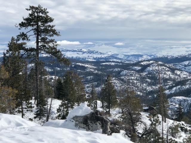
-
Looks Like Garrett Is Coming Out With A New Detector(s)
HardPack replied to John-Edmonton's topic in Garrett Metal Detectors
1964 Eleanor and Charles Garrett establish their business April 1, 1964. Looks as if like we are approaching Garrett’s 60th anniversary. Maybe this is the event we have been waiting for: