Search the Community
Showing results for tags 'gps and mapping'.
The search index is currently processing. Current results may not be complete.
Found 8 results
-
I’ve seen the more typical geosurveys used for mapping faults and exploration of oil and gas using thumper trucks or a dead weight along with a long string of geophones with them (vibration sensors strung along a long line across the ground to pick up the vibrations), but I was not aware of the more passive technique called Ambient Noise Temography (ANT) surveys. I just saw an ad here on DP about it from this company- it’s pretty interesting what they are doing and legit too- it’s not a gold spear or anything like that, but probably many times more expensive than those as well because it depends on you using several of these sensors. ANT surveys use a grid of sensors that measure ambient Earth motions like local disturbances form humans like trains and trucks, and ocean waves hitting the coast many miles away to measure and map underground geological features they say over 2km deep. It’s pretty cool technology that mining companies are using. For a deeper review of it (skip the 1st minute):
-
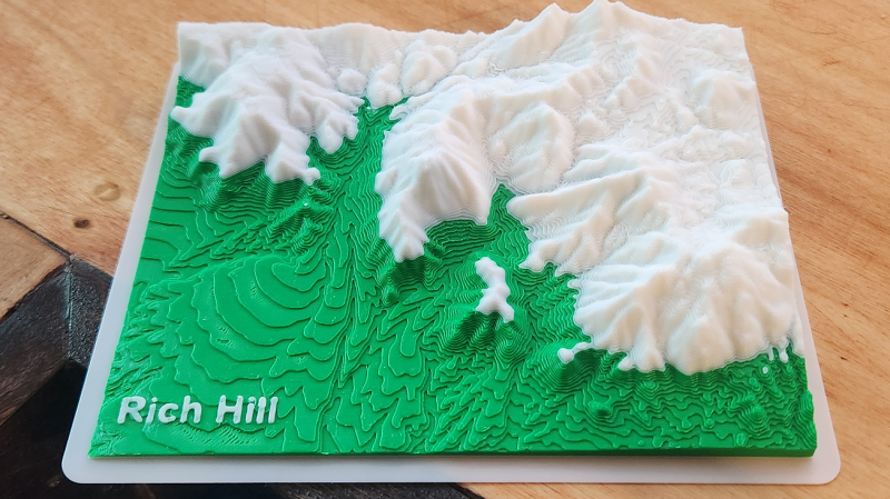
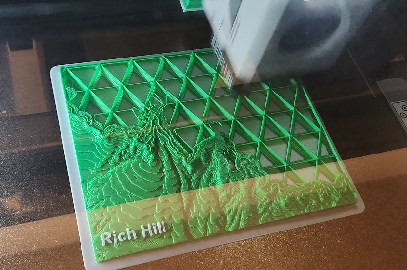
I bought myself an early Christmas present in order to make a few specialized brackets/clamps that I didn't want to pay to get manufactured. Finishing that, I decided to print myself a desk ornament. And here it is complete, I just spitballed the coloration at the point the old gravels stop and meet the granites. These models are pretty useful for estimating paleo surface and drainages and whatnot if you spend the time and get more accurate with the coloring and go to 4 colors. I'm still trying to work out a hack to get a topo map or a geologic map printing on the top surface, haven't figure out how yet though. These are good for scaling up to like 500 square miles and mapping specific elevations with different colors, and quick visualization of that sort of data, for exploration purposes. You can do similar in Google Earth but it's plane feature in 3D view is buggy and shifts heights, which has caused me to unknowingly miss some areas on aerial research. Also, there is just something more intuitive about having the physical model in hand and seeing the topographic relation of all the terrain. You can make your own .STL's from DEM data for any location in the world here: https://touchterrain.geol.iastate.edu/

-
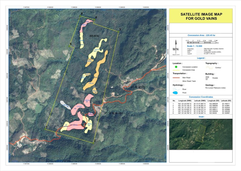
 Hello Dears, I hereby ask for your opinion regarding a request that I received from someone on the internet: He told me that he can sell me a map taken with Satellite which determines the places where there is gold and the veins of gold for $500. Thank you in advance for your support
-
Yay! Minelab finally updated Xchange 2 so it still works with Google maps, some time ago Xchange being so old was no longer compatible with Google maps and they've finally fixed the problem somewhat properly using a patch that runs in the background. You can download the fix to your Xchange 2 (Windows) here https://www.minelab.com/__files/f/507670/XChange2-1.8.7-1.3.5-Hotfix.exe XChange2 - Hotfix for mapping and pin fixes. (Released July 2023) External interfaces used by XChange2 change over time which can affect the way that XChange2 needs to work. Installing the XChange2 Hotfix file after installing the XChange2 1.8.7-1.3.5 program will help XChange2 maintain it's compatibility with Google maps so that detectorists can continue to use the program as intended. Step 1 - Download and install XChange2 1.8.7-1.3.5 Step 2 - Download and run XChange2-1.8.7-1.3.5-Hotfix.exe (This will take a few minutes.) Step 3 - Restart your computer then run XChange2 as normal. (the Hotfix will run in the background.) --- Note for Minelab, maintain its compatibility. 🙂
-
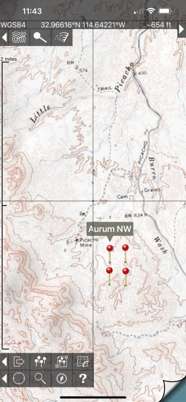
For off-road mapping with subscription fees, there’s Gaia and XMap (I don’t know which of these will work beyond the US, probably Gaia only), and there are a few other subscription mapping apps that you have to pay for maps with. In the US and Canada, I have been using Topo Maps (for Apple IOS (there’s a great looking non-subscription fee program for Android listed in the next post below). https://topomapsapp.com/ it costs $8 initially with no subscription fees after that, and provides unlimited free use of all USGS topographic maps of US, and all Canadian Topo maps as well. To use these, you preload the maps in either low or high resolution mode onto your phone so you can use it without cell phone coverage. You can navigate with it via your phone or iPad with GPS and it shows where you are real-time on the topos, and you can put in and export custom waypoints. It also has a search function to show where different named features are including many mines. I use the waypoints to mark claim boundaries and other points of interest. Phones have GPS built in, but if your iPad does not have built-in GPS, you can get a separate Bluetooth unit like a Garmin GLO for about $99 to give it that utility. I use it for my older dash mounted iPad for off-road navigation in my truck. Topo Maps iPhone zoomed in screenshot made in low- resolution mode (not a real claim!):
-
Back in the 90s switched from HF Flying Doctor comms to vehicle Optus Satellite then handheld Inmarsat, all served me well. However found I have evolved to using email only so have been toying with switching to the cheaper subscription Zoleo or InReach systems. Well I bit the bullet and went with a big screen ie bigger touch keyboard for old eyes and big fingers, got a Garmin Montana 700i back a month or so.... Wow lovely big 5inch bright sunlight viewable colour touch display, Birdseye View map overlay included along with upgraded Toppos. Been happy as using Android phone w/. Oziexplorer plus Garmin Rino 750 when prospecting with Son but this newer tech has replaced the Inmarsat. InReach has shown to be easy as, much cheaper and the added bonus of that SOS button, and syncs with phone/PC either via BT, WiFi or USB. First become aware of InReach on a thread on DP a fair while back so maybe is time to refresh and discuss InReach/Comms again.
-
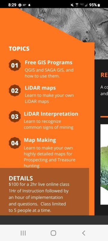
I came across this class. It might be of interest to some of you. Seems to be expensive at a $100 bucks for the class. But just think if it gets you a couple of nuggets. https://theprospectinggeologist.com/online-lidar-map-making-class/
-
I don't know exactly where to put this so I'll start here. Maybe Clay has it on his links or someone else has posted it but it got me to some maps I would not have found. I still don't understand most of the nomenclature. https://ngmdb.usgs.gov/mapview/?center=-97,39.6&zoom=4 MapView Betaby the NGMDB MapView lets you explore some of our favorite geologic maps from the NGMDB (USGS/AASG).


.thumb.JPG.b46839319dc8de4aefe1f42407094dbd.JPG)

.thumb.jpg.77e4cb5bf39d44bdd2050d2edb7dfdb1.jpg)