Search the Community
Showing results for tags 'gps and mapping'.
-
It seems that the Lidar map availability has changed formats. Has anyone tried & figured out the new site & process to view? USGS Lidar Explorer Map https://apps.nationalmap.gov/lidar-explorer/#/
-
I’ve seen the more typical geosurveys used for mapping faults and exploration of oil and gas using thumper trucks or a dead weight along with a long string of geophones with them (vibration sensors strung along a long line across the ground to pick up the vibrations), but I was not aware of the more passive technique called Ambient Noise Temography (ANT) surveys. I just saw an ad here on DP about it from this company- it’s pretty interesting what they are doing and legit too- it’s not a gold spear or anything like that, but probably many times more expensive than those as well because it depends on you using several of these sensors. ANT surveys use a grid of sensors that measure ambient Earth motions like local disturbances form humans like trains and trucks, and ocean waves hitting the coast many miles away to measure and map underground geological features they say over 2km deep. It’s pretty cool technology that mining companies are using. For a deeper review of it (skip the 1st minute):
-
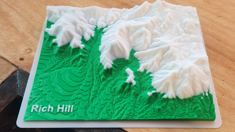
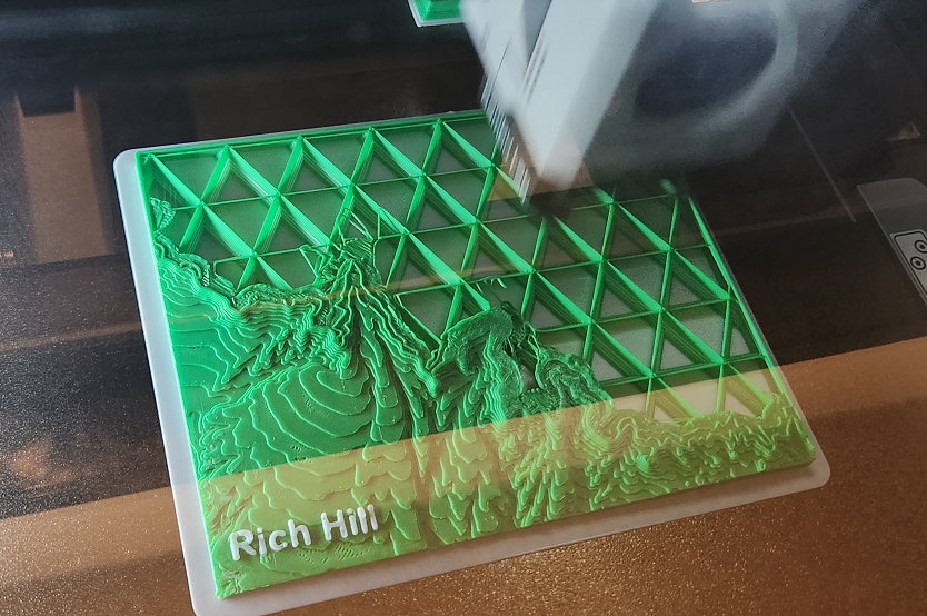
I bought myself an early Christmas present in order to make a few specialized brackets/clamps that I didn't want to pay to get manufactured. Finishing that, I decided to print myself a desk ornament. And here it is complete, I just spitballed the coloration at the point the old gravels stop and meet the granites. These models are pretty useful for estimating paleo surface and drainages and whatnot if you spend the time and get more accurate with the coloring and go to 4 colors. I'm still trying to work out a hack to get a topo map or a geologic map printing on the top surface, haven't figure out how yet though. These are good for scaling up to like 500 square miles and mapping specific elevations with different colors, and quick visualization of that sort of data, for exploration purposes. You can do similar in Google Earth but it's plane feature in 3D view is buggy and shifts heights, which has caused me to unknowingly miss some areas on aerial research. Also, there is just something more intuitive about having the physical model in hand and seeing the topographic relation of all the terrain. You can make your own .STL's from DEM data for any location in the world here: https://touchterrain.geol.iastate.edu/

-
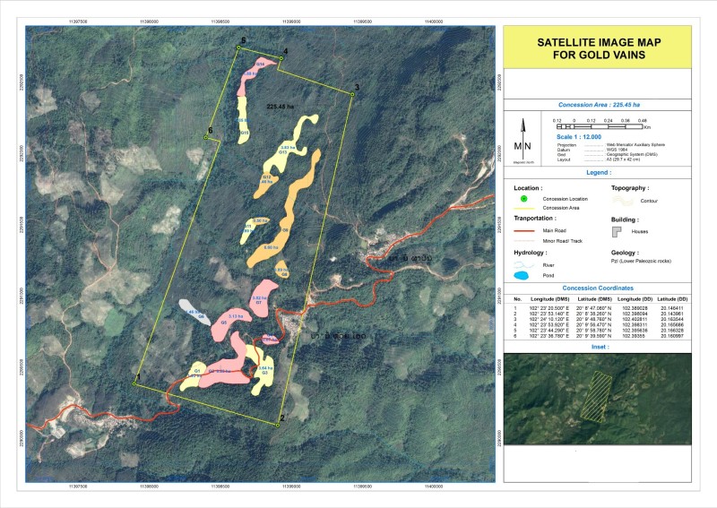
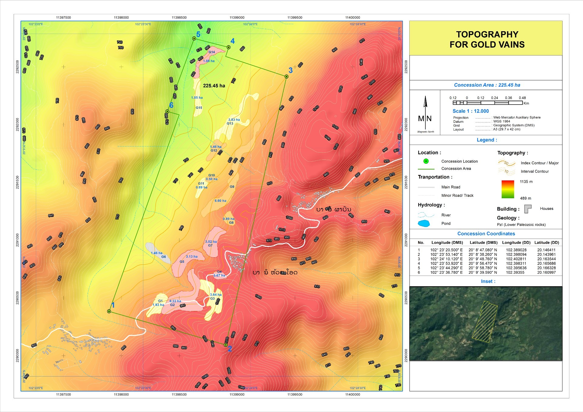
 Hello Dears, I hereby ask for your opinion regarding a request that I received from someone on the internet: He told me that he can sell me a map taken with Satellite which determines the places where there is gold and the veins of gold for $500. Thank you in advance for your support
-
Yay! Minelab finally updated Xchange 2 so it still works with Google maps, some time ago Xchange being so old was no longer compatible with Google maps and they've finally fixed the problem somewhat properly using a patch that runs in the background. You can download the fix to your Xchange 2 (Windows) here https://www.minelab.com/__files/f/507670/XChange2-1.8.7-1.3.5-Hotfix.exe XChange2 - Hotfix for mapping and pin fixes. (Released July 2023) External interfaces used by XChange2 change over time which can affect the way that XChange2 needs to work. Installing the XChange2 Hotfix file after installing the XChange2 1.8.7-1.3.5 program will help XChange2 maintain it's compatibility with Google maps so that detectorists can continue to use the program as intended. Step 1 - Download and install XChange2 1.8.7-1.3.5 Step 2 - Download and run XChange2-1.8.7-1.3.5-Hotfix.exe (This will take a few minutes.) Step 3 - Restart your computer then run XChange2 as normal. (the Hotfix will run in the background.) --- Note for Minelab, maintain its compatibility. ?
- 6 replies
-
- 2
-

-
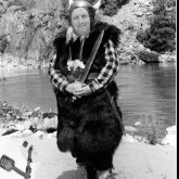
- minelab gpz 7000
- minelab ctx 3030
- (and 1 more)
-
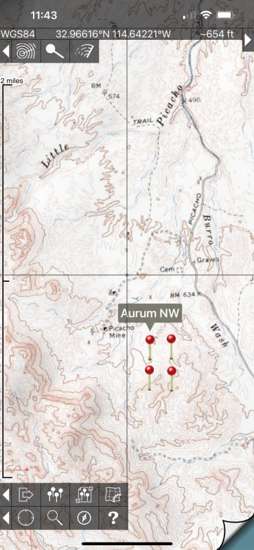
For off-road mapping with subscription fees, there’s Gaia and XMap (I don’t know which of these will work beyond the US, probably Gaia only), and there are a few other subscription mapping apps that you have to pay for maps with. In the US and Canada, I have been using Topo Maps (for Apple IOS (there’s a great looking non-subscription fee program for Android listed in the next post below). https://topomapsapp.com/ it costs $8 initially with no subscription fees after that, and provides unlimited free use of all USGS topographic maps of US, and all Canadian Topo maps as well. To use these, you preload the maps in either low or high resolution mode onto your phone so you can use it without cell phone coverage. You can navigate with it via your phone or iPad with GPS and it shows where you are real-time on the topos, and you can put in and export custom waypoints. It also has a search function to show where different named features are including many mines. I use the waypoints to mark claim boundaries and other points of interest. Phones have GPS built in, but if your iPad does not have built-in GPS, you can get a separate Bluetooth unit like a Garmin GLO for about $99 to give it that utility. I use it for my older dash mounted iPad for off-road navigation in my truck. Topo Maps iPhone zoomed in screenshot made in low- resolution mode (not a real claim!):
-
Back in the 90s switched from HF Flying Doctor comms to vehicle Optus Satellite then handheld Inmarsat, all served me well. However found I have evolved to using email only so have been toying with switching to the cheaper subscription Zoleo or InReach systems. Well I bit the bullet and went with a big screen ie bigger touch keyboard for old eyes and big fingers, got a Garmin Montana 700i back a month or so.... Wow lovely big 5inch bright sunlight viewable colour touch display, Birdseye View map overlay included along with upgraded Toppos. Been happy as using Android phone w/. Oziexplorer plus Garmin Rino 750 when prospecting with Son but this newer tech has replaced the Inmarsat. InReach has shown to be easy as, much cheaper and the added bonus of that SOS button, and syncs with phone/PC either via BT, WiFi or USB. First become aware of InReach on a thread on DP a fair while back so maybe is time to refresh and discuss InReach/Comms again.
-
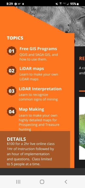
I came across this class. It might be of interest to some of you. Seems to be expensive at a $100 bucks for the class. But just think if it gets you a couple of nuggets. https://theprospectinggeologist.com/online-lidar-map-making-class/
-
I don't know exactly where to put this so I'll start here. Maybe Clay has it on his links or someone else has posted it but it got me to some maps I would not have found. I still don't understand most of the nomenclature. https://ngmdb.usgs.gov/mapview/?center=-97,39.6&zoom=4 MapView Betaby the NGMDB MapView lets you explore some of our favorite geologic maps from the NGMDB (USGS/AASG).
- 1 reply
-
- 7
-

-
-
- advice and tips
- geology
- (and 1 more)
-
I have been seeing an ad for Zoleo at the top of the DP page and thought you folks might be interested to hear an opinion about it. I bought one a year ago and have taken it with me whenever I go detecting because where I go is out of cell phone range. I am highly impressed with this little gizmo. It is about the size of a pack of smokes, it's very lightweight and easy to hook onto a harness or belt loop. I won't go into too many details but I encourage anyone who is interested in getting a satellite communicator that works very well to look into this one.It is a relative new kid on the block - but it has great and responsive customer service. It uses an app on your phone so, for instance, you can type a message on your phone but send it with the Zoleo if you are out of phone range and family or friends who download the app can use it to contact you as well. It has a check-in button to say "I'm okay" and gives the coordinates. It uses the Iridium satellite network…the good one…to relay a help call in case of trouble, with all the help that call triggers. It is worth reading up about, there is a lot in a small well-thought-out package. I have no association with the company. Oh, and Happy Holidays to everyone...
-
 I have updated my files for historical goldmines in Google Earth and have put them in PDF file that makes it simple to get the type and state that you want. Historical Gold Mines in Google Earth.pdf
 -
I thought I’d try using a pedometer just to see how far I stroll along the beach on my hunts. The reviews I’ve read on many are not very complimentary. It seems the common complaint centers on accuracy and battery life. I’d appreciate your thoughts and recommendations. Thanks
-
I thought it would be cool to overlay a geological map onto a topographical map. And maybe a property map onto an aerial image map. Then I would like to put these custom maps onto a smartphone GPS app. That way when I’m in the field, I can see that I’m in a favorable rock type area or approaching a private property boundary. I see that MapWindow is a free GIS software that will let me make map layers. And for smartphones, it seems that Gaia GPS is a popular app. Does anyone have experience making custom maps on their desktop then downloading them onto a smartphone GPS app? If so, what desktop software and smartphone app do you like? Google Earth has layering capability... has anyone use GE to create downloadable map files for a smartphone? PS, if you have done this for a handheld GPS instead of a smartphone I'd enjoy hearing about that as well. Thanks
-
Thinking of downloading the Gaia GPS App to my iPhone. Wondering if anyone has experience with this App? Thanks for any input.
-
Hello, I am using an iPad as a topo map when I’m out in the field, and also GoogleEarth, and have already downloaded the BLM’s active and inactive gold mine and prospects KML database for Google Earth and was wondering if anyone has found a good source for downloading BLM and/or National Forest KML files? I only seem to have found some local ones for Alaska on the BLM map server website, but nothing for any of the lower Western states. Thanks!
-
I use to mine in No. CA in the 80s & 90s and used topographical maps back then with lots of details , fire & logging road etc. Any suggestions , I would like to check display & available details ?
-
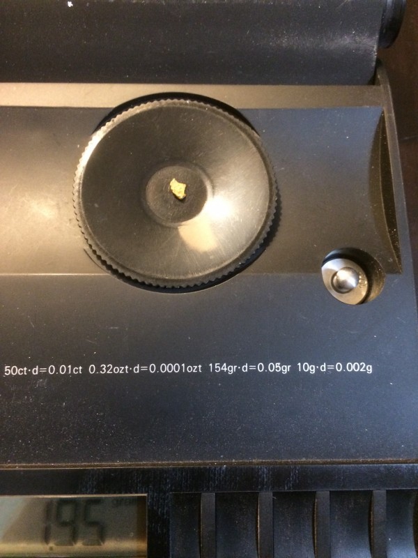
I haven’t been able to get away and hunt very much this year due to various reasons and last week I finally found a little free time so I headed to the hills for a few days of hanging out with Zed. In anticipation of getting away for a hunt I called Rob and had him send me one of those new SteelPHASE enhancer/filter’s and wow fastest shipping I’ve ever experienced, Rob must have jumped on a plane and stuffed it in my mail box, or could have just been overnight shipping anyway it was really fast. Gold was very scarce nails, tiny bits of rust, tacks and bird shot were a plenty the tiny piece of gold weighing in at a whopping 1.95 grains I did find this trip gave a clear indication down under around 3” of forrest mulch and soil, this is the smallest bit of gold I’ve found with the 7000 to date. I’d attribute finding this piece to the sP01 it made the zed a little more stable and tightened up the target response it was easier to tell the difference between ground noise and targets and I was digging some deep small bits of rusty nail and other itsy bits of trash. The sP01 was comfortable to carry too, I was a little concerned about adding another gadget to the mix with more cables to get in the way and after getting my enhancer I was thinking the cable used for connecting to the wm12 might be a little long. Wrong, everything was perfect and if not for the fact my detector was running great I could forget anything was different in my setup. With the sP01 clipped to my zed harness on the head phone shoulder side and the wm12 on the other shoulder the cable ran perfectly over the wm12 shoulder around my back and under the arm on the sP01 side. Once plugged in the cable never hung up or got in my way was comfortable, really great product engineering. I also bought a SpotX satellite device, so many (most) of the remote areas we go into alone have no cell service and help is a long way off. In short it’s good, but not great an evolving technology. In a nutshell it works although on its own schedule at least with non-emergency texts, most of mine were sent, some did not and I think there are limitations on how soon one text can be sent after another I’m still figuring the little quirks out something with traffic limitations and the system needing to reset...but, don’t ask cause I don’t know. The service has nine different rates based on 3 different plans, a basic, advanced and an unlimited service ranging from around $14 a month to $40 a month for the unlimited flex plan. The basic plan monthly payments gets you 12 texts a month, the advanced plan get you 100 texts a month plus more frequent satalite access and unlimited is well... the three tiers are repeated except when you pay the year up front you get all your available text limit for the year and they all are good for the entire year plus it’s a couple bucks cheaper, the three levels are again repeated as flex, this has slightly higher rates and no one year commitment you can start/stop as it fits all the plans come with an $100 activation fee. I chose the advanced with 1200 texts for the year. I also added rescue insurance, roadside assistance and replacement insurance for an additional $85, the rescue insurance provides $100K/$50K per occurrence, roadside 50miles towing free, off road ok and winching service available at the push of a button that also sends the tow service your gps and a map with your location pinpointed, you can also send the gps data and map with a text. All in all The device, tax, fee and service for the year set me back roughly $750, cheap insurance I think. There are also other tracking and social networking features, it’s actually a great device and gave me some comfort knowing if I needed I could get help and also it was great being able to send my wife a note and let her know everything was good.
-
Hello everyone, I'm getting my first GPS device and narrowed it down to a few. I was wondering if anyone experienced with these can tell me if im doing this correctly or not. ? Garmin GPSMAP 66s or GPSMAP 64s. Which one would last the longest, most durable Also, correct me if im wrong. For us electronic prospectors wouldnt it be a good idea to get the HuntsView map? Or do i get the SE 24k and combine it with the BirdsEye What map(s) do you all use?
-
I use Google Maps for most of my navigation and prospecting trips. It gets me to where I want to go and if I download the offline map I still know where I am out in the field with the GPS on my phone. I can put in locations from various formats but I still have not been able to find the format for putting in the numbers in the UTM-EAST and UTM-NORTH format. How is that done on the search bar in maps? Mitchel
-
Has anyone used “Land Matters” website to look for a prospecting site? I recently did, and today I went out to the selected spots. None of the topo photos were the same, some roads and trails don’t exist anymore. I also forgot to take my GPS...Those photos must be ancient!
-
Finally got a video up that goes over and shows some the uses and benefits of lidar maps for the gold prospector and metal detectorist. I also delve into some drone usage stuff at the end of the video. Let me know what you think, and if your interested in some feel free to contact me. I will hopefully have a website up in the near future, when i do i will let everyone know here. Thanks for watching!
-
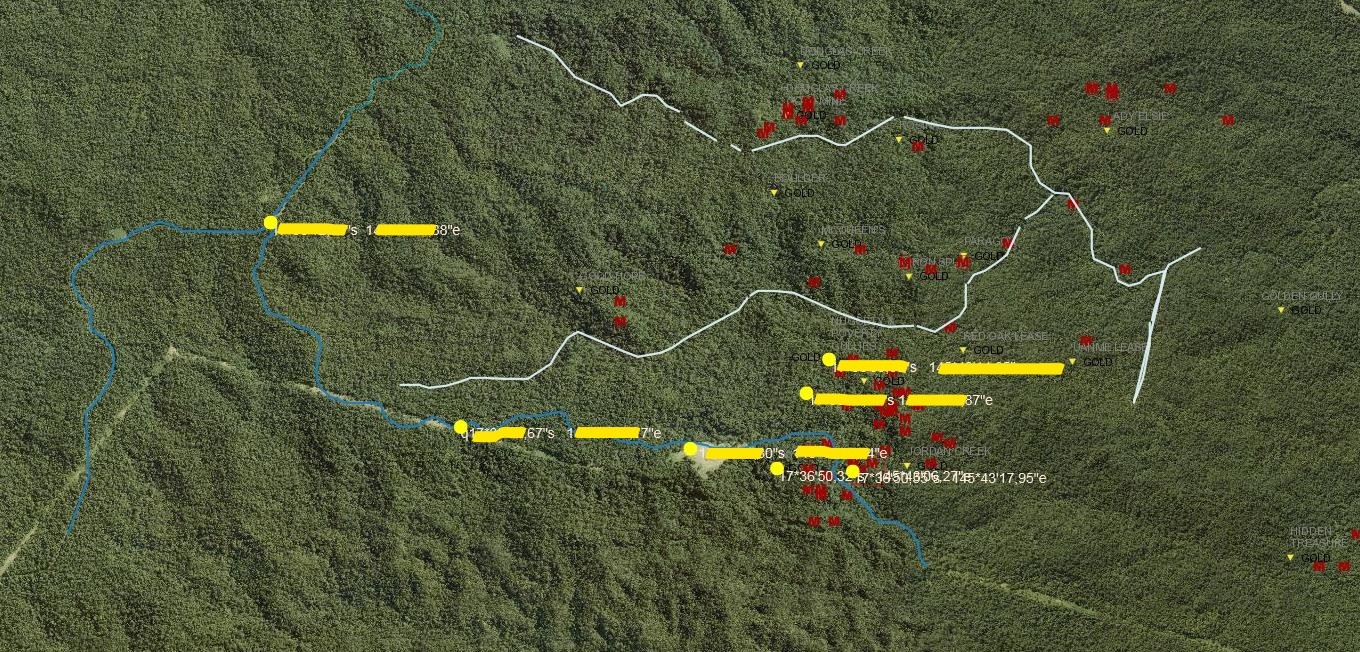
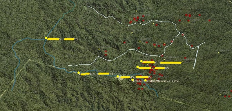
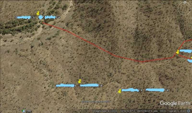
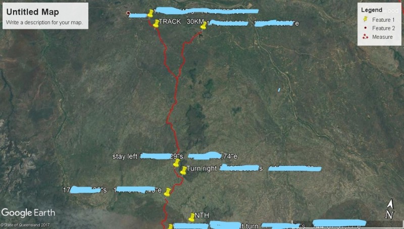
G'day everybody, Just thought I would start a thread on making your own gold maps to better your chances at striking it rich or at least finding a bit of gold. If this topic has already been done before please let me know & I'll remove it. I can't find anything specific on making your maps on the forum. So what are the things available for us to use in making custom gold maps? Geological maps, topographical maps, books such as Ghost & gold series, Department of mining websites, google earth etc...there is plenty of resources that we can use. I live in sunny north QLD Australia, so any info I can share with you will be based on what we have available in our QLD. Every state in Australia has its own mining department along with (rules and regulations) that differ from state to state. Department of Mines & Energy in QLD is the website I use to gather a lot of information, so far it has paid out very well in some areas. In particular small isolated gold occurrences. I often look around the fringes of existing gold fields looking for potential gold locations especially along fault lines with historical gold workings. The more remote the area the better, as there are fewer chances of modern detectors having worked the area in recent years. To get the ball rolling I thought I would just post a couple of pics of areas I have researched & marked out where I've found gold & see where it leads us.
-
Not sure if any of you knew of this site: https://www.historicaerials.com/ They have a view that shows old photos back to 1938 and topos going way back. The viewer is slow but has nice reference as you can click through the dates and see changes. It is a little hard to see but you can see some old trails, lost foundations and even early farm fields that have either been built over or trees have grown in. I use it to find some spots and I plug the gps coordinates into my phone's gps.
-
We've been considering some additions to the map tools on Land Matters and would like user's feedback. Land area locations in the U.S. are typically described by their legal land description (PLSS). This is the only system that has been physically surveyed and has actual physical markers on the ground. That's why it's the system for legally describing land parcels. All the Land Matters maps have the PLSS included as a possible display item but a lot of people (military) have been trained to use a grid to describe actual ground locations. Graticules are very much like grids but they have the advantage of following the earth's curvature, unlike grid maps. Digital graticules are capable of increasing in resolution as you zoom in to an area. These are advantages of a graticule but the use of a graticule is just like using a grid. It's possible to use both the PLSS and a graticule when mapping so we thought we would see if some people would like the option of using a grid type mapping system. To that end I have included graticule layers on our historic places and ghost towns map to let folks try out this system and see if they would like these layers included on other Land Matters maps. If you have an interest give it a try at the Historic Places Map. You can read more about grids, graticules and their uses on our New Projects page. Let us know if you would like this feature added to the maps. It's a bunch of work to make those changes so we'll have to see some demand before we add these in. Barry
-
Maybe some of you already know about this and have the phone to support it. I have one of the flip phones that nobody wants to steal, so it really amazes me. On his phone he dials up google earth map and it instantly it brings up the boundaries, acreage and name & address of the owner. It would be fantastic to have the same ap for claims, showing owner and boundaries, no more accidental trespassing.


.thumb.JPG.b46839319dc8de4aefe1f42407094dbd.JPG)

.thumb.jpg.77e4cb5bf39d44bdd2050d2edb7dfdb1.jpg)