Search the Community
Showing results for tags 'drones'.
Found 16 results
-
Does anyone here use a drone to help cover more area when looking for places to prospect? If so, how helpful do you think it is?
-
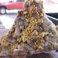
My first day out of Melbourne Australia for a long time was spent exploring Nuggetty Hills near Maldon in Victoria. Felt good to get some fresh country air. Rocky hilly terrain meant I used a drone to get a better view. The drone has proven itself a very useful tool, for prospecting and more. All the best.
-
The importance of using a good quality metal detector suitable for prospecting has been widely explored in great detail. The introduction of the GPX 6000 highlights the gains in technology and thank goodness, ergonomics. Weight and Balance, at last. Matched by performance and cutting edge technology.. The one fact remains that at the end of the day the key is to get the coil over the gold. Some truly magnificent gold that has been found, could have been detected by any half decent prospecting machine. Still we should invest in quality and the new Minelab sounds superb. We need to utilize every tool at our disposal. Often after extensive research, Google Earth images, maps, books and word of mouth can all lead us to a certain goldfields. When we arrive there is a lot of suitable ground to explore. Perhaps too much ground and not enough time to give it the attention it deserves.. In an effort to narrow the search I have started to use a drone when exploring a new area. It allows me to gain perspective, to more clearly focus on areas and features of interest. When the terrain allows it, this will same me a lot of time and increase my odds of putting a coil over a target. Viewed from the ground vegetation can mask features which kind of pop up when viewed from the air, the drone allows me to focus on a smaller area of interest.
-
Have you ever wondered what the cutting edge mining drones are doing these days? Here is one company that gives an idea at the large scale level. They call it Hovermap. https://www.emesent.io/industries/mining/?utm_campaign=Mining Campaign Dec'20&utm_source=EDM-AM-7May2021&utm_medium=EDM-AM-7May2021&utm_term=EDM-AM-7May2021&utm_content=EDM-AM-7May2021 What if you don't have any lidar? Make your own. Does anyone know anything about placer mapping?
-
 This is a really great paper describing how you can use the latest technology (AI) and algorithms to locate meteorites. Now just imagine what else you can find if you have the time and knowledge. There are a few here on this forum who will be enlightened by this article but certainly not surprised. It is just a matter of time that we process massive amounts of data quickly. https://arxiv.org/pdf/2009.13852.pdf
-
- 6
-

-
- meteorites
- drones
- (and 1 more)
-
I'm looking into getting a quadcopter for photogrammetry, but have no experience with them at all. Are there specific features that are better than others? What kind of camera resolution is best, and are shutter speeds and drone stability usually good enough to capture good quality, usable photographs? I'm at the beginning of my research, so any tips and recommendations would be greatly appreciated. I saw some information about drones in this article: https://thedigitalcamera.net/best-drones-with-camera/, please tell me which is the best.
-
Simon do you have one of these? or have you set up the QED on a Drone already
-
Recently my wife and daughter gave me a drone for my birthday. Being a bit of a technical dinosaur, I am still getting the hang of it. These things seem to be rapidly advancing, and it occurred to me that it may provide a way of seeing what is over the next hill without all the footwork. Seeing how America seems to be leading the way with this technology, this seemed to be the ideal place to pose this Question. Any ideas?
-
Amyone on the Forums have any drone experience yet? just wondering.....This guy does. Enjoy! Cheers, ig
- 13 replies
-
- 10
-
-
I wish they had been a bit more adventurous with distance from base camp with this but it gives at least an idea of the possibilities....
-
Is there anyone on here that use a Drone to survey the area you plan on nugget hunting are coin hunting ? I was thinking about getting one to look over land that has a lot of trees that could have a old home site you can't see from the road. I'll let you know up front I don't go where I don't belong. If I do find something of interest then I'll spend the time looking for the owner. Drones are like detectors and that is just how much money you want to spend. Chuck
-
 This seems like an amazing possibility for prospecting off road, hard-to-get-to areas.
 -
 Ok guys, I've been working really hard on this new video. I think it truly shows what treasure hunting is all about! We used the new dji Phantom 4 drone to scout out an old 1800's underground house that was across the creek from us. The footage is my best yet and I even took the time to play guitar for all the backing tracks. Hope you enjoy this edition on "Off the Grid Treasure Hunting"... Now... Let's get lost!
 -
Who's going to be the first to use a drone scout up that wash that you'd love to hike up but crap it's warm your old it's nearly vertical geewhiz I still like to have a look! Seriously Dash anybody thinking of using drones to scout out likely New terrain?
-
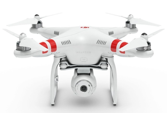
You guys have great Google Earth coverage down here. It is nearly useless in Alaska and I would have been thrilled to have this alternative. As it was I was lucky enough to have a father with an airplane I could talk into doing aerial photography runs. Aerial views can be incredibly handy in rough terrain, or terrain with lots of trees. Anything that stops you from seeing what is "over there". It is so easy to miss stuff wandering around on foot. As I noted, Google Earth is a huge aid, but it is not perfect. The best time to see stuff is when the leaves are off, and often Google Earth overviews are obscured by foliage. This unit is designed to work with a Go Pro camera and so costs less than models with integrated camera solutions. I am not expert in this stuff and just grabbed this as an example because they seem to be a well known manufacturer. The DJI Phantom Aerial UAV Drone Quadcopter for GoPro at http://www.amazon.com/DJI-Phantom-Aerial-Drone-Quadcopter/dp/B00AGOSQI8/ Then there is a top-of-the-line model with integrated camera on gimbal. The Go Pro model you aim the drone to get the shot. This one you can hold the drone steady and rotate the camera. More money of course. DJI Phantom 3 Vision Quadcopter with Integrated FPV Camcorder at http://www.amazon.com/DJI-Phantom-Standard-Quadcopter-Camera/dp/B013U0F6EQ/ref=dp_ob_title_toy Anyway, just food for thought. We found aerial photography to be a huge benefit metal detecting the tailing piles at both Ganes Creek and Moore Creek.