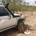
HardPack Posted February 24 Share Posted February 24 Homestead Cabin on January 28, 2024 Homestead Cabin on February 23, 2024 Homestead Cabin on March 8, 2024 . 6 1 Link to comment Share on other sites More sharing options...
Guys gold Posted February 24 Share Posted February 24 Maybe the lakes can hold the runoff without sending to the ocean Link to comment Share on other sites More sharing options...
HardPack Posted February 24 Author Share Posted February 24 14 hours ago, Guys gold said: Maybe the lakes can hold the runoff It appears the storage reservoirs are currently at 90% capacity. If a pineapple express hits during March there may be some flooding in the lower elevations and Central Valley . Right now the stream flows are normal for winter….frozen. 1 Link to comment Share on other sites More sharing options...
Valens Legacy Posted February 24 Share Posted February 24 Looks like just the right amount of snow to be able to use your metal detector for a few hours. Make sure your sense is set on high. Nice pictures. Link to comment Share on other sites More sharing options...
HardPack Posted February 24 Author Share Posted February 24 6 hours ago, Valens Legacy said: Looks like just the right amount of snow to be able to use your metal detector for a few hours Been working on a rechargeable 12v heat gun coil adaptation plus deep seeking Bluetooth equipped snowshoes. My thinking is that it’ll be similar to snorkeling without the wet of liquid water. If this all works out the next cabin shack build is planned for a beach along a South Pacific Island. 2 Link to comment Share on other sites More sharing options...
HardPack Posted February 28 Author Share Posted February 28 Been experiencing Spring like weather for the last couple of days but that is about to change. The National Weather Service just issued a blizzard warning for the Sierra Nevada west slope for Thursday 2/29/24 through Sunday 3/3/24. “…One to four feet of snow is forecast above 4,000 feet. Four to ten feet of snow is expected above 6,000 feet. Snowfall will range from 2 to 4 inches per hour. Winds could gust as high as thirty-five to sixty-five mph, especially on exposed ridgetops and along the crest. Widespread blowing snow will create blizzard conditions, with white-out conditions and near zero visibility. Very strong winds, combined with a heavy snow load could cause extensive tree damage and extended power outages. Wind chills as low as fifteen to twenty below zero can be expected.” link to California Weather Watch Be prepared, stay warm, stay safe and good luck! 2 Link to comment Share on other sites More sharing options...
HardPack Posted February 29 Author Share Posted February 29 Here’s a local Central Sierra Nevada 6,500 to 8,500 foot elevation snowfall forecast issued this morning February 29, 2024. Currently the Sierra snow pack water content is between 75% and 80% of average for this time of year. “…here are the current snowfall predictions for the next few days: tonight- 17-23″, Friday 13-19″, Friday night 22-28″, Saturday 20-26″, Saturday night 14-20″, Sunday 5-9″ before the system winds down and heads East. 99-137″ is some impressive snowfall in the short duration…” Should see the Sierra snow pack water content approach 100% of average by the end of this storm system which will translate into a normal Spring runoff. But standby there may be more on the way later in the week. Link to comment Share on other sites More sharing options...
HardPack Posted March 5 Author Share Posted March 5 At the elevation of 7,200 feet the Central Sierras south of Lake Tahoe received 56 inches of snowfall from the last storm system exceeding 100% of average water content statewide for March 4th equating to normal stream runoff. However, the current foothill rainfall totals are below 70% of the annual average resulting in lower ground water levels and reduced summer stream flows. amended: As of March 4th, 2024 statewide snow pack is 104% of average water content; the Tuolumne and Stanislaus watersheds are 87% water content for the water year starting on October 1st, 2023. Current snow depths: Yosemite Hwy 120 Tioga Pass elv. 9,945ft =122 inches, Hwy 108 Sonora Pass elv. 9,624ft =86 inches; Hwy 4 Ebbetts Pass elv. 8,736ft = 96 inches. During the storm the highest wind speed over the Sierra Nevada summits measured 190 mph. 1 1 Link to comment Share on other sites More sharing options...
HardPack Posted March 9 Author Share Posted March 9 For snow depth comparison added March 8, 2024 photo to the original February 23rd post. Another winter storm is inbound. Link to comment Share on other sites More sharing options...


Recommended Posts
Create an account or sign in to comment
You need to be a member in order to leave a comment
Create an account
Sign up for a new account in our community. It's easy!
Register a new accountSign in
Already have an account? Sign in here.
Sign In Now