Search the Community
Showing results for tags 'gps and mapping'.
-
.......... The Ordnance Survey TRAIL Here's what i found: 1. Software is utter useless tosh! Error messages, jerky movements, sluggish. Im tech savvy - But this thing takes a computer programmer to operate. 2. The touch screen doesnt react. There made to last and take knocks, but still you cant move the screen to look at your maps. 3. Mine turned up faulty with rubber joystick not allowing me to look left. 4. Price is stupendously high for a piece of poo. 5. Signal takes an age and a half to lock on. 6. WIFI takes an age to sync, other times it never will. (That was the last straw). 7. Compass is the worst i have ever used. Never, even after calibration does it show a true heading. Spoke to customer service and they said there not too reliable. Hang on ..... Dont I rely on the compass to find my way around on foot?? He sounded confused ... and again this was the last straw. And so...... I now have the Garmin Montana 680. AND ..... Its bloody brilliant. Review to follow ? Andy.
-
My "Old Faithful" Garmin GPSMap 60CSx appears to be reaching the end of its serviceable life, after years of being dropped on rocks, bikes, down slopes, drenched, fallen into rivers, taped onto dogs, and being the point of contact on its bike mount between Terra Firma and myself head over heels on my mountain bike. Starting to malfunction a tad if you can believe it! Can't say enough good about it - some of the best money I ever spent bar none :) I do a ton of work with Google Earth plotting targets, claims and such. My stompin' grounds are devoid of cellular data, so any device that is DetectorProspector approved and might have some capabilities for satellite imagery, overlays - I would really appreciate guidance. rex
-
I didn't find any results when I searched. I'm looking for some advice on a good hand-held GPS to use when prospecting. Is there such a thing as one that is easy to use and easy to connect to a computer? Thanks for helping a novice.
-
 We are going to be moving to Tinker AFB, OK in June, but in the meantime, while still based on Eglin AFB, FL, I have been researching old, now demolished family housing areas to hunt before we leave. I have discovered a major housing area, where all the homes were built between 1955 and 1962. Still standing in 1969, but now demolished and open fields. Very easy to research using NETRonline Historic Aerials against current Google Satellite maps. The kicker of this area is that it is on-base, and due to very restricted access, these fields are very likey virgin for hunting. I expect a lot of silver, wheaties and more in the front areas of these homes, as well as the always-open fields behind the housing circles, where kids would play, and parties held. Only hunting them will prove out my theory, but I have four remaining weeks at Eglin to find what I can! Here are the Aerial vs. current satellite pics. After we leave, I hope someone into MD'ing will be assigned to Eglin and find this post. (Of course, I hope I've already recovered ALL the silver!! LOL)
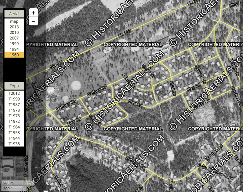
-
Maybe some of you already know about this and have the phone to support it. I have one of the flip phones that nobody wants to steal, so it really amazes me. On his phone he dials up google earth map and it instantly it brings up the boundaries, acreage and name & address of the owner. It would be fantastic to have the same ap for claims, showing owner and boundaries, no more accidental trespassing.
-
So... I'm imagining a GPS device that has a direct link to GPS satellites, that pretty much can pinpoint my exact location anywhere on the planet, dually allowing me to drop pins and take notes. I feel like this device exists. Anyone have a link, or know of a device that functions this way?
-
Anyone use this? I've read mixed reports on it in terms of android/apple and that it is out and being used and that it's currently not available for use. This would be a huge assist/help to me in hunting the areas I currently have permission for. I never quite figured out the GPS on my CTX and am hopeful my iphone can be integrated into my detecting.
-
Does anybody know why a gravel bar in a creek on Google Earth would show as Pink instead of black and white? This is in central Indiana, not much in colored rocks or mineral deposits in the area. It is a glacial gold area and with copper nuggets but they don't show up on aerial maps. I did spot a large gray clay stream bank on another creek which had alternating layers of red and gray just above the creek line like an ice cream cake. Too bad its owned by the state and they refuse to let us prospect there. It is a known gold creek too. It cannot be seen without Google Earth and a Historical Imagery view of the woods taken March 30 ,2005, otherwise tree cover blocks the view on both of these creeks. What's the best color laser printer for around $300 for aerial map prints? -Tom V.
-
A review Anyone who uses the BLM LR2000 search function knows it can be a challenge to get meaningful results. Often the service is down but you aren't notified of a problem with the system until you go through the whole complex search process to discover there was an "error". Frustrating at times. Well it appears the BLM decided it was time to change the look and feel of the LR2000 search function. They notified users months ago that they were working on an improved version but they caught a lot of people by surprise when they introduced the NEW! IMPROVED! LR2000 on November 1 and shut down the functions of the OLD! BAD! LR2000 at the same time. Problem was they didn't tell anyone. The old LR2000 still appears to be there and will allow you to do a search. That search returns an error, as mentioned earlier that's not unexpected or uncommon when using the LR2000. I use the LR2000 a lot when I need the most recent information on a land or claim case file. It took me nearly 24 hours after the changeover to get fed up enough with the old LR2000 not working to try the new LR2000 which has been available but not working for the last nine months. I'm hoping the BLM will set up that old LR2000 web address to redirect to the new LR2000 page so others won't have to waste their time beating a dead search system like I did. The old LR2000 was clunky. It reminded me of an old unfamiliar broken down right hand drive truck with a Japanese language repair manual. It was really that awkward and counter intuitive. There were many blogs, manuals and videos devoted to explaining the esoteric mysteries of the BLM's version of public access to public records, I even helped write a few myself. I made good use of the old LR2000 on the days it was working and I was glad to have it when I could get results but it needed fixing. The new LR2000 has a cleaner less intimidating interface with a slightly simpler set of options. I really don't like the "black topo" background the BLM now puts on all their web pages. If you like the black topo theme you are probably going to like the look of these new search pages better than the old ones. The behind the scenes search function has changed a lot from the old LR2000. I tried it on several browsers and three operating systems. I had problems on every browser and system. The Search seems to hang in some circumstances, in others it returns results as quickly as the old LR2000. The actual search itself seems to be slower sometimes. Every browser I tried had problems when it had run a few searches. The searches would eventually hang and several loops would keep the browser so busy it would lock up. That's not something I'm used to experiencing. This is a new system so I'm hoping the BLM will get these glitches out soon. The results of each search now displays in a new interface. Essentially there will be a window frame on the results page with the document displayed inside the frame as a PDF. Like the old LR2000 there are options to download the document in several formats including Excel, PDF and HTML. You can now modify or start a new search from the results page. Land Matters has made an effort to bypass the clunky old LR2000 interface and allow you to directly access any claims BLM serial register page directly with a few clicks on a map. This turned out to be a lot quicker way to get information on claims in a specific area without having to pound through the old LR2000. Being a direct live link to the BLM the information is as current as possible unlike other mapping programs that present static information updated every month or so. When the unannounced changeover in LR2000 search systems happened it broke Land Matters system of direct access. With more than 380,000 mining claims being actively tracked Land Matters had a problem. Claims Advantage Members also get several reports a month. In the last two days Land Matters had released two reports with a combined total of more than 20,000 maps and direct links to a broken LR2000. That's 400,000 missing documents. Sometimes life can be.... interesting. Needless to say I have been busy. It took 24 hours but I deciphered the new LR2000 system, fixed the links to the serial register pages and corrected, compiled and uploaded new member reports. The mining claim serial register pages linked to on the maps load more quickly than the old ones did. If you have any problems with those maps or the Member Reports please let me know. Please try out the new LR2000 and share your experiences here. Try the Mining Claims Maps at Land Matters and marvel at the new search results. If you like the way the map link system works we can add the feature for a lot more types of research. Barry
-
While up in the Sierra for a WSPA Outing I used my gpz. I had not used it since I did the upgrade. When I pushed the map button the man-icon came up but there were no tracks. The unit would mark a point and display it but no tracks to see where I had wandered. I also noticed the unit would not return to correct threshold in a timely manner. Nor did the other functions always work correctly... two different issues I think. What say yea? fred
-
 A video I made that might help someone who uses a Google Earth and wants to transfer that data onto a GPS. I use this all the time to quickly drive/walk into areas that I've researched online. My other video that I did shows you how I overlay old maps onto Google Earth. Hope it helps at least someone.
 -
For a few years now I have been fascinated with a map that was published in 1915, but this map is very hard to work with, because most of the roads that are on it no longer exist and there is no sign of them what so ever and most of the tracks that are currently there are not on the map. It took me a bit of mucking around to get 2 maps the same size and location, but I found a free site where you can overlay one image onto another. This is part of the original map that shows roads that are no longer there and the bottom map I have overlayed the original to put in the tracks that are currently there from a topographic map. This map now becomes way more user friendly for me because of the overlayed tracks. Somebody else may find this site useful. Dave https://www.imgonline.com.ua/eng/impose-picture-on-another-picture.php imghost
-
www.maprika.com Speaking of old topo's... I've been using this android app since last year and it works great. For locating cellar holes from old topo maps it's a dream. Basically you overlay your topo on a google map, plot some reference points, and the topo is rectified to a modern map with GPS ability. The more reference plots you create the more accurate the rectification. Works with hand drawn maps too. I've ran it at four different sites and it's really very good. IMO, it's the best thing out there to simplify our searches. Do yourself a favor and try it.
-
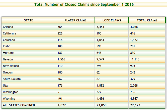
Gosh it's that time again. Spring has sprung across all the states and prospecting is going into full swing for the season. Land Matters updated their Mining Claims Maps last Friday morning. We also updated them on the 15th of May and May 1 and April 15 - you get the idea. In any case Land Matters always provides the most up to date claims mapping available at any price. We serve up thousands of these maps every hour and those numbers keep growing so I know folks are getting their prospecting mojo on with the help of Land Matters. That's a good thing! We've got some new tools coming soon to make your research even easier and more productive. Keep an eye out for those updates soon. For those of you who are Claims Advantage Members you may have noticed there has been a significant change to one of the most famous mining districts in California. New ground opening up for the first time since 1890. This is a major opportunity for any serious prospector. Here's the number of claims closed so far this mining year: Land matters has provided maps of all those 27,127 Closed Claims for our Claims Advantage Members.
-
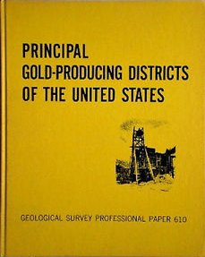
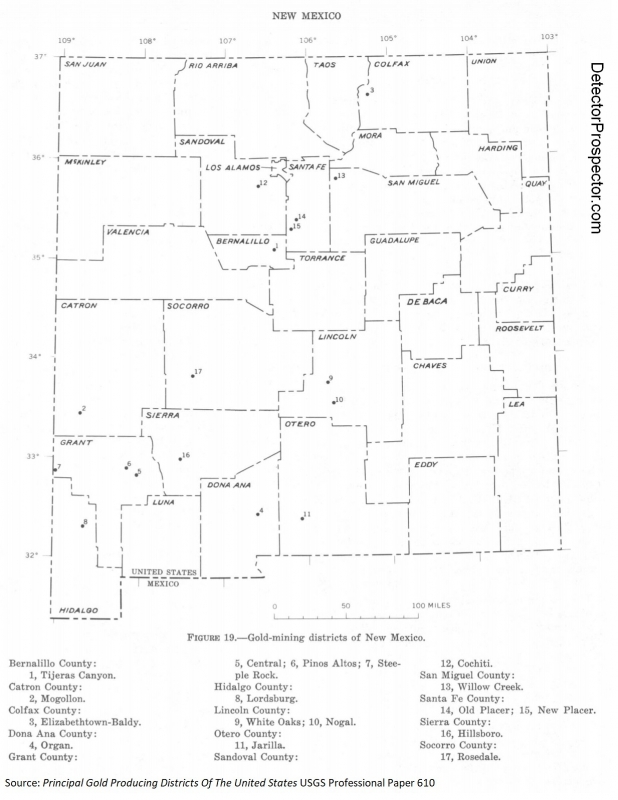
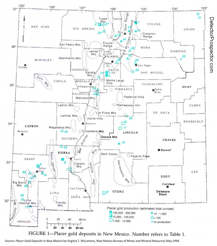
 Another question via email, with personal references removed. I prefer to answer these on the forum so everyone gets the benefit of the answer plus others can offer their opinions also. "I am new to metal detecting and, your site here has really helped me out. I have a couple questions that maybe you can help me out with. What are some of the geologic indicators that you look for to determining where to prospect for nuggets? I try to study some of the geology maps but I could use some further pinpointing. I have also been looking at the National map of Surficial Mineralogy. Using the aster and minsat7 maps what are some of the indicators that may point you to higher gold bearing ground? Any help would be deeply appreciated. Could you point me to some old places where you have found gold? I'm not asking to be shown active patches. Just areas that you feel are worked out. I just want to see what gold bearing ground looks like. This would help me to start to learn the commonalities and characteristics of gold bearing grounds. Still looking for that first nugget! Thanks again for any info you can provide." My method is much simpler than that. I basically look for gold where gold has been found before. Think of it like fishing. If you want to go catch salmon you have two options. You can go to where people have caught salmon before - pretty good odds here. Or you can go where nobody has ever caught a salmon before. Very poor odds! So call it prospecting using history to determine where gold has been found before, and then getting as close as I can to those places. History and proximity. Finally, I may then employ geology to narrow that search in a given area if it turns out the gold is confined to certain rock types. The first place I normally turn as a rough guide to any new location in the U.S. is: Principal Gold Producing Districts Of The United States USGS Professional Paper 610 by A. H. Koschmann and M. H. Bergendahl - A description of the geology, mining history, and production of the major gold-mining districts in 21 states. This 1968 publication obviously lacks the latest production figures but it still is a great overview to where an individual prospector can look for gold in the United States. It is a 283 page pdf download so be patient. Pay particular attention to the listed references in the extensive bibliography for doing further research. You can download this here and find many more useful free books on this website at the Metal Detecting & Prospecting Library Principal Gold Producing Districts of the United States So just for fun let's say I want to go look for gold in New Mexico. The section on New Mexico starts on page 200 and here is a quick summary of the opening paragraphs: "The gold-producing districts of New Mexico are distributed in a northeastward-trending mineral belt of variable width that extends diagonally across the State, from Hidalgo County in the southwest corner to Colfax County along the north-central border. From 1848 through 1965 New Mexico is credited with a gold production of about 2,267,000 ounces; however, several million dollars worth of placer gold was mined prior to 1848. Mining in New Mexico began long before discoveries were made in any of the other Western States (Lindgren and others, 1910, p. 17-19; Jones, 1904, p. 8-20). The copper deposits at Santa Rita were known and mined late in the 18th century, and placer gold mining began as early as 1828 in the Ortiz Mountains south of Santa Fe. In 1839 placer deposits were discovered farther south along the foot of the San Pedro Mountains. The earliest lode mining, except the work at Santa Rita, dates back to 1833 when a gold-quartz vein was worked in the Ortiz Mountains. In 1865 placers and, soon afterward, quartz lodes were found in the White Mountains in Lincoln County; in 1866 placer deposits were discovered at Elizabethtown in Colfax County, and silver-lead deposits were discovered in the Magdalena Range in Socorro County. In 1877 placers and gold-quartz veins were found at Hillsboro, and in 1878 phenomenally rich silver ore was found at Lake Valley in Sierra County. The mineral belt of New Mexico is in mountainous terrain that lies between the Colorado Plateau on the northwest and the Great Plains on the east. It is a zone of crustal disturbance in which the rocks were folded and faulted and intruded by stocks, dikes, and laccoliths of monzonitic rocks. Deposits of copper, lead, zinc, gold, and silver occur locally throughout this belt. Some deposits of copper and gold are Precambrian in age, but most of the ore deposits are associated with Upper Cretaceous or Tertiary intrusive rocks. The gold placers were probably derived from the weathering of these deposits. In later Tertiary time lavas spread out over wide areas of the State, and fissures within these rocks were later mineralized. These fissure veins are rich in gold and silver, but in most places they are relatively poor in base metals. In New Mexico, 17 districts in 13 counties yielded more than 10,000 ounces of gold each through 1957 (fig.19). Figure 19 is a handy map showing us where you want to look in New Mexico and also where looking is probably a waste of time. Click for larger version Gold mining districts of New Mexico The map shows what the text said "The mineral belt of New Mexico is in mountainous terrain that lies between the Colorado Plateau on the northwest and the Great Plains on the east." Sticking to this area is going to be your best bet. Based just on this map I see two areas of general interest - the central northern area, and the southwestern corner of the state. The text mentions that placer deposits were discovered at Elizabethtown in Colfax County, and the map shows that as the Elizabethtown-Baldy mining district. Following along in the text we find this: "The placer deposits along Grouse and Humbug Gulches, tributaries of Moreno Creek, each yielded more than $1 million in placer gold and silver. Another $2 million worth of placer gold and silver was recovered from the valleys of Moreno and Willow Creeks (Anderson, 1957, p. 38-39), and some gold also came from the gravels along Ute Creek. Graton (in Lindgren and others, 1910, p. 93) estimated the placer production of the Elizabethtown-Baldy district prior to 1904 at $2.5 million, and C. W. Henderson (in U. S. Bureau of Mines, 1929, pt. 1, p. 7 40) estimated the production through 1929 at about $3 million (145,138 ounces). The total placer production through 1959 was about 146,980 ounces." The reference material from the passage above is in the back of the book and is where we can get real details. Google is our friend. This stuff used to take me lots of visits to libraries! Anderson, E. C., 1957, The metal resources of New Mexico and their economic features through 1954: New Mexico Bur. Mines and Mineral Resources Bull. 39, 183 p. Lindgren, Waldemar, Graton, L. C., and Gordon, C. H., 1910, The ore deposits of New Mexico: U.S. Geol. Survey Prof. Paper 68, 361 p. Henderson, C. W., 1932, Gold, silver, copper, lead, and zinc in New Mexico: U.S. Bur. Mines, Mineral Resources U.S., 1929, pt. 1, p. 729-759. That is more than enough, but let's also Google placer gold new mexico Lots of great links there, but two jump out: Placer Gold Deposits of New Mexico 1972 USGS Bulletin 1348 by Maureen G. Johnson Placer Gold Deposits in New Mexico by Virginia T. McLemore, New Mexico Bureau of Mines and Mineral Resources May 1994 Notice the source of the last one. Most states with much mining have a state agency involved that can be a good source of information and in this case it is the New Mexico Bureau of Mines and Mineral Resources. That last one is a real gem and contains this passage: "All known placer deposits in New Mexico occur in late Tertiary to Recent rocks and occur as alluvial-fan deposits, bench or terrace gravel deposits, river bars, stream deposits (alluvial deposits), or as residual placers formed directly on top of lode deposits typically derived from Proterozoic, Cretaceous, and Tertiary source rocks (eluvial deposits). During fluvial events, large volumes of sediment containing free gold and other particles are transported and deposited in relatively poorly sorted alluvial and stream deposits. The gold is concentrated by gravity in incised stream valleys and alluvial fans in deeply weathered highlands. Most placer gold deposits in New Mexico are found in streams or arroyos that drain gold-bearing lode deposits, typically as quartz veins. The lode deposits range in age from Proterozoic to Laramide to mid-Tertiary (Oligocene-Miocene) (Table 2). There are some alluvial deposits distal from any obvious source terrains (Table 2). Eluvial deposits are common in many districts; some of the larger deposits are in the Jicarilla district." So now we have a lifetime of ideas on where to go and a basic idea of the geology. And an even better map! Click for larger version. Placer gold deposits in New Mexico Let's look for specific site information. 1. Go to http://westernmininghistory.com/mines 2. Click on New Mexico Mines 3. Click on Colfax County Mines 4. Click on Elizabethtown - Baldy District Here you will find basic site information, references, and a zoomable map with alternate satellite view. An alternate site... 1. Go to https://thediggings.com/usa 2. Click on Browse All States 3. Click on New Mexico 4. Click on Browse All Counties 5. Click on Colfax At this point note you can browse mining claim information or deposit information. Researching mining claims, land ownership, etc. is another topic but here is one source of mining claim location information. For now.... 6. Click on Browse All Deposits or Use The Interactive Map 7. Click on Elizabeth - Baldy A little more detail than the previous site, including this note "SOME FAIRLY COARSE NUGGETS IN WILLOW, UTE, SOUTH PONIL CREEKS, GROUSE AND HAMBURG GULCHES, MORENO RIVER" One more... 1. Go to https://www.mindat.org/loc-3366.html 2. Way down at bottom click on New Mexico 3. Way down at bottom click on Colfax County From here you can dig into all kinds of specific site information but the navigation is a real mess. Have fun! Historic claim staking activity can be a clue. You can get the Big Picture by looking at Mine Claim Activity on Federal Lands for the period 1976 through 2010 OK, that really should have answered your question. As far as places I have been, they are nearly all in Alaska and can be found here. Now, I did all the above from scratch with no real prior information on New Mexico in about 2 hours. You can do the same for any state. However, finding where the gold is really is the easy part. The hardest part by far is finding out who controls the land and getting proper permission for access. In Alaska everything is covered by thick ground cover, so opportunities for metal detecting are strictly at creek level, and nearly always claimed. The process there is simple - find out who owns the claims and get permission for access. In most of the western U.S. there is far less or no ground cover, and so getting in the vicinity of and searching around or near mining claims without being on them is a far more viable option than in Alaska. Or you can try and get permission to access the properties. You still need to be able to track down property locations and owners however. For private property I subscribe to and use OnXMaps for my PC, Google Earth, iPad, and iPhone. It quickly maps private property and gives you access to tax roll information about the owners. Tracking down mining claims is easy in the big picture and harder in the details. The Diggings referenced before has interactive claims maps. I subscribe to Minecache for their Google Earth overlay. However, the most comprehensive source with the deepest repository of Land Ownership information is Land Matters. They have online claim mapping with direct links to claims owner information. Note that all online sources have a lag time between the actual staking of a claim on the ground and when it reaches the online systems, if ever. I say if ever because some claims exist solely at the county or state levels and there is no good way to find them short of visiting local recorder's offices or eyeballs on the ground. Prior thread on finding claims information. Finally, I am not an expert geologist by any means. This is just how I go about it, but any tips, hints, advice, or information anyone is willing to share on this thread are very welcome!!
- 12 replies
-
- 25
-

-

-
- mining claims
- gps and mapping
- (and 1 more)
-
http://www.oldmapsonline.org/ And they have a phone app!
-
 So now that I have a Rino, what's the best way to put claim maps on it? Or do i need to use some of the online map sites and plug my own lat/longs into a custom route? I downloaded the base camp app and have watch the tutorials, its just gonna take a while to build surrounding claims and such by hand.
 -
I'm not sure what forum to post this, many of us use Google Earth though so here it is, the new version which I just saw released. https://www.google.com/earth/ Kinda let down personally... Cloud storage of my KMZ's...not going to ever happen with me. Also, looks like they eliminated most of the actual useful tools from the desktop version, bummer. There does appear to be some previously unreleased high res imagery in at least some locations anyways though so that's cool. Haven't really had time to look through it a lot yet, maybe I'm missing something new that is actually useful, dunno.
-
Hi guys, Thought I would share this new app I have been using while out in the field on my android tablet. http://www.offline-maps.net I find the satellite imagery awfully slow to scroll and refresh on ozi explorer android, so got this one for general navigation as it is much faster loading. It works offline and has helpfull options to easily select and store wanted areas at various resolutions. The waypoint options are nicely laid out and include lots of customization. At $3.99 for the ad free version its even priced right!
-
Hello to u all.. Im seeking help from u for how can locate gold areas by using satellite or google map in northern and east Sudan bcz its my country and from that areas.. and if u have any updated special map from Sudan or any way of special searching through websites or satellite.. thanks for all help.. Lutfi...
-
When I and a friend try to lock on and co-ordinate the same feature on google earth our co-ordinates do not match. The variation is off about 3 minutes. Our computer settings for google earth are exactly the same but I`m not sure if we are running the same version. Any ideas?
-
Fairly new to detecting and starting to explore more. Was thinking about buying a small GPS unit to upload coordinates and topographic maps, does anyone have a preferred unit or an app on their phone that does a good job keeping them inbounds?
-
I am mostly out there alone. IF you do get lost or disoriented and can't find your way back to your truck, do you panic , use a GPS, or do what to get back to camp? -Tom
-
Are there any updates for the aftermarket skid plate for the 19" and could you comment why the GPS should not be used on ZED?
.thumb.jpg.13740cd6abe45f493193ed39c27f67fd.jpg)