Search the Community
Showing results for 'drone'.
-
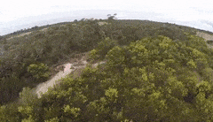
The last drone video was over Ballarat Hill next to Vaughan township. Wedgetail Eagles are locals, spotted a while ago so I know they live in the area. All jokes aside they are local wildlife and they do not like drones. They are protected and numbers have been increasing, I do check before flying and have had to abort flights because they are hovering about. I just keep the drone on the ground and reach for the DSLR with a telephoto lens and enjoy having them around. Beautiful big birds with a bit of attitude..
-
No Wedgies either, I hope! It certainly looks like you’re in the right type of habitat for them. You’re getting a lot of use out of your drone for reconnaissance, very nicely done!
-
Just including an updated version of an older drone video, flying over another goldfield trying to identify private and public land boundaries before swinging the detector. The hole in the hillside were on private land, so I flew over for a closer look whilst staying on the public side of the fence.. no livestock, farm house or farmer with 12g..
-
I'm using a DJI Mavic Air, video set at Auto at 1080P 60fps with an ND filter fitted most of the time. I use an Ipad Mini mated to the controller, the Ipad serves as a digital map and satnav when out on foot away from the car. Usually in the car is a pelican style case for the drone with everything I need. Compact and versatile with decent video output it perfroms well for me. I have four battery packs for the drone and can recharge in the car, but four is plenty for a normal weekend away. Got to the stage I even do a quick fly over when picking out a spot to pitch my tent, it has found me a very nice camping location complete with a great fishing and prospecting. The day will come when these gadgets deliver pizza..
-
GotAU I am lucky that in Victoria a lot of historical maps and information has been digitized, so is fully available to the public. Lots of information to research areas, perhaps too much at times. My method is to identify an area of interest, locate and reseach reports and maps etc. I print out a topographic map, identify private and public land. Make sure I am not on a working or active mining claim. Make sure I am permitted to prospect in the area and go from there. Google Earth research to identify points of interest within the area, followed by drone flights and putting on a pair of good boots. At all times I update my printed map using an old school pencil. Many times on my walks I spot broken pottery or glass, bricks or other bits and pieces that tell me there has been a camp, test holes and other indicators that I should start detecting. The old map I included with the Google Earth image highlights areas with reefs and shafts, granite and alluvium. Just part of a detailed process involved in narrowing down areas of interest. Finding 'shallow ground' with nuggetty gold is one thing but narrowing the search from 'excavator shallow' to 'small coil shallow' is for me the real challenge. A complex but enjoyable process, I suspect many more experienced prospectors instinctively know what ground is of interest. By instintively I mean hundreds of hours of research and hundreds more of real world experience..
-
Great video Karelian! Thanks. What type of drone do you use? Video quality is great!
-
Just keep your 'cotton picking' drone out of my spots. At about the two minute mark I can clearly see where I worked four different patches, one in the company of JR Beatty, which yielded over a hundred bits. The land owners were on percentage All of that lower country is private property, and if an eagle doesn't get your drone a 12 gauge just might. (just kidding) Fence jumpers not welcome.
-
What fun, and a pretty place too! Looks like there could be some places one should test or detect there, and that name- “Nuggetty Hill”. What is the prospecting history there? As for a drone being helpful for prospecting, I agree. Used mine before to see if there was any exposed float on a hillside above me, it worked well. And you could attach one of those high tech $5K super long distance gold spears to your drone too, who knows what it may point to flying over Nuggetty Hill again! 😉
-
My first day out of Melbourne Australia for a long time was spent exploring Nuggetty Hills near Maldon in Victoria. Felt good to get some fresh country air. Rocky hilly terrain meant I used a drone to get a better view. The drone has proven itself a very useful tool, for prospecting and more. All the best.
-
I watched that vid yesterday ! Nice drone truck ...you could hover over a spot and blow away everything except the nuggets ! Make yer boots last longer too.. I want to know where those jet packs they promised everybody would have back in the 60s are being hidden !
-

Charging The Gpx-6000 In A 1/2 Ton Truck Or A Car/van?
GotAU? replied to Gerry in Idaho's topic in Detector Prospector Forum
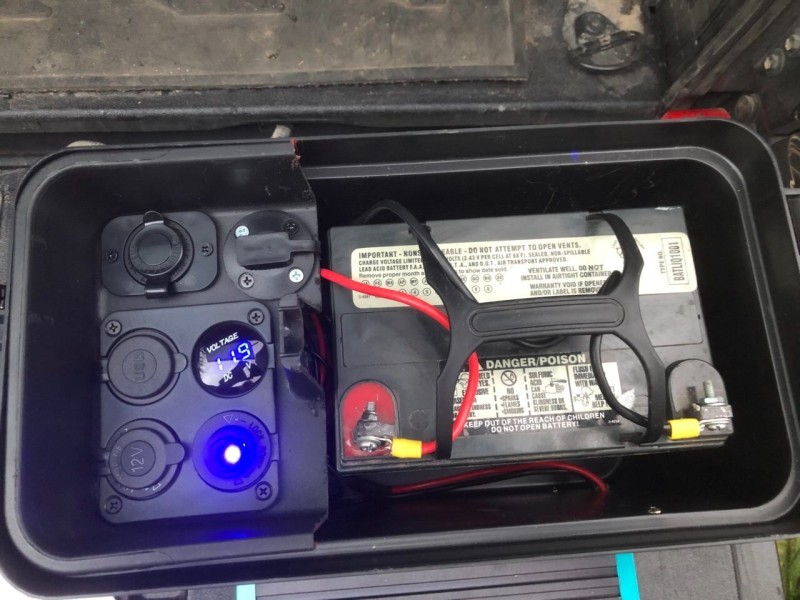
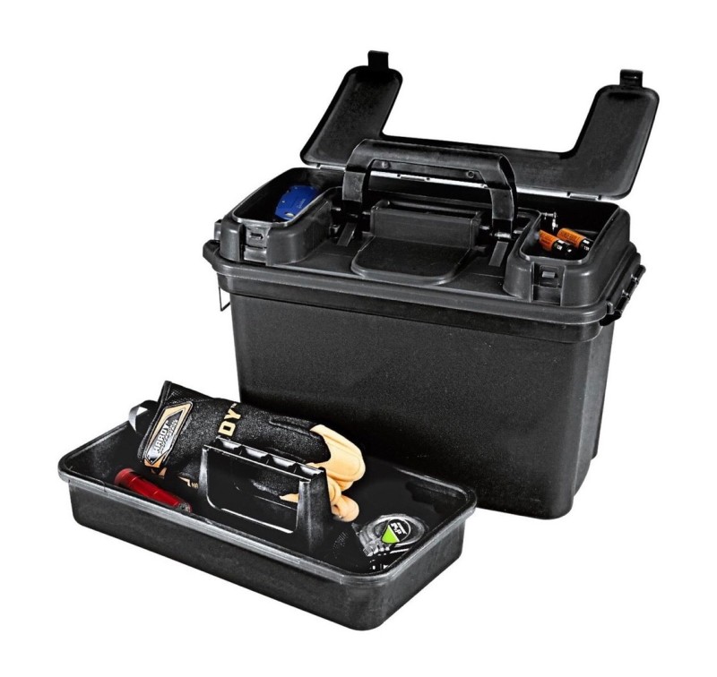
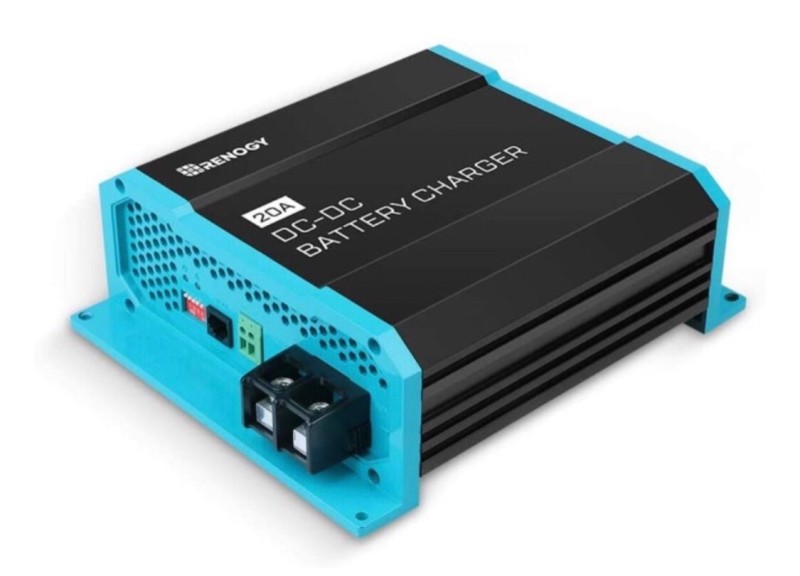
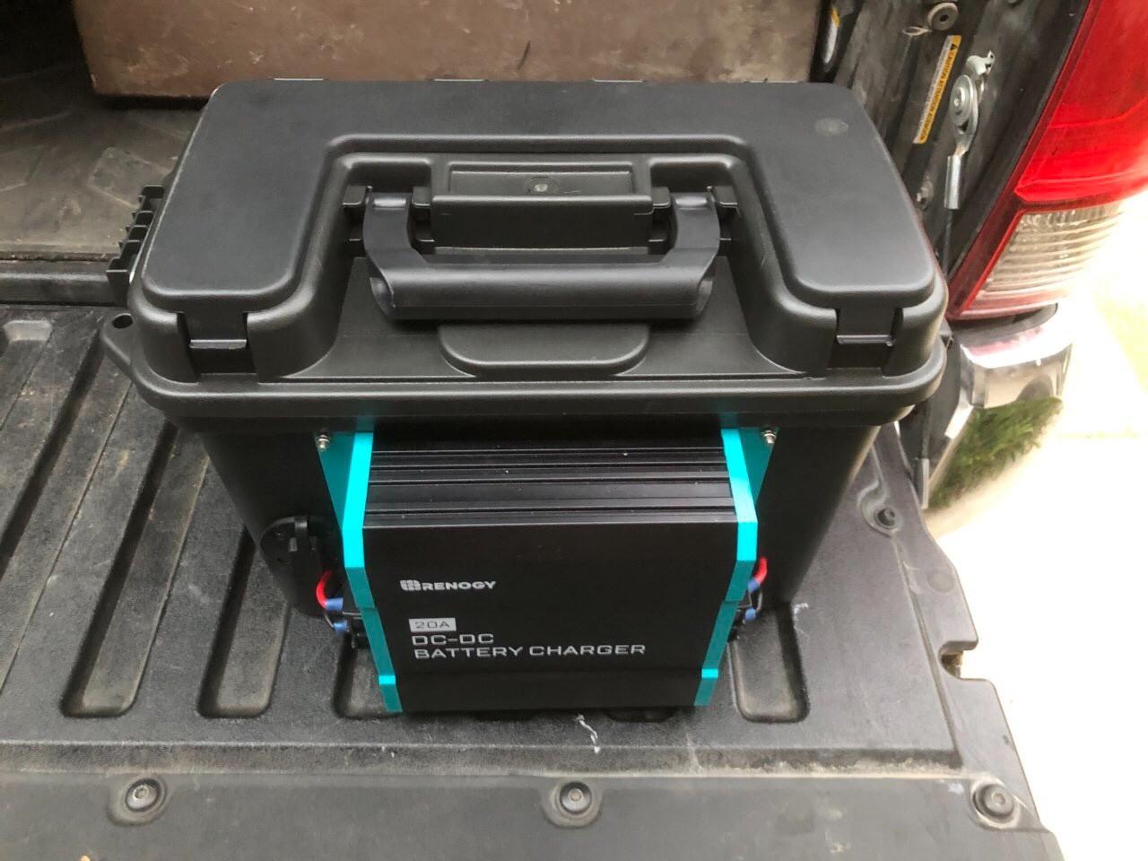
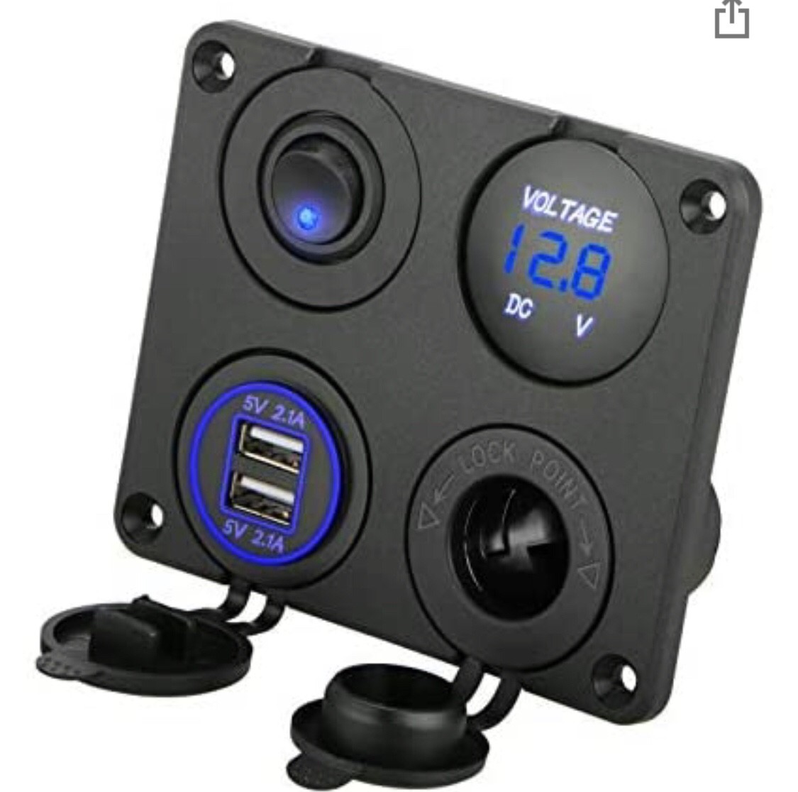
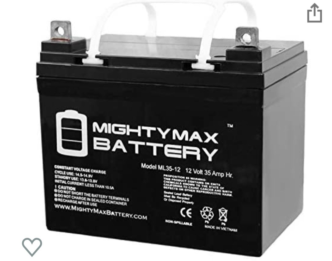
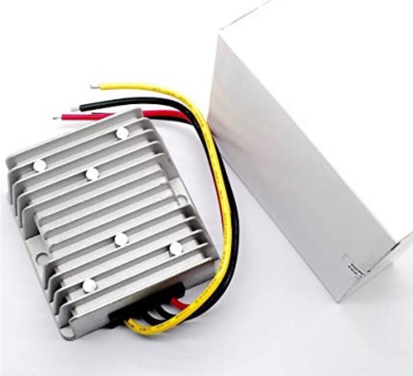
I made this 12v 35Ah (420Wh) portable power battery with left over parts, but you can do it for $100 to $250, depending on options you want, such as solar charging, vehicle charging vs. 120v charging, adding a 120v power inverter, etc. When fully charged, it runs our refrigerator for a day and could provide about 6-8 charges for GPX-6000 batteries without drawing it down too low. The battery is based on a low cost 12v 35Ah deep cycle gel cell made for mobility scooters and trolling motors like this: ML35-12 - 12 Volt 35 AH SLA Battery- Mighty Max Battery Brand Product https://www.amazon.com/dp/B00K8V2VD0/ref=cm_sw_r_cp_api_glt_fabc_5R2WR55KHZYEF1202G21 The Renogy 20amp DC-DC battery charger lets us charge it from solar panels and from our truck batteries- it will automatically charge when the truck is running too: Renogy 20A DC to DC On-Board Battery Charger Flooded, Gel, AGM, and Lithium Batteries Using Multi-stage Charging https://www.amazon.com/dp/B07Q5VYPCF/ref=cm_sw_r_cp_api_glt_fabc_YD8N92AHJP683K2SA7HH?_encoding=UTF8&psc=1 The case is a $9 HF plastic ammo box with a built-in handy cover storage area for cables, connectors, etc. I cut about 1/3 off the side of the tray and used it to mount the switch panel and 12v and USB charging plugs to: https://www.harborfreight.com/tactical-ammoutility-box-64113.html And I added a switch, voltage meter, USB power plugs and a cigarette lighter plug port like this to it: Linkstyle 4 in 1 Charger Socket... Linkstyle 4 in 1 Charger Socket Panel, 12V 4.2A Dual USB Charger Socket Power Outlet & LED Voltmeter & Cigarette Lighter Socket & LED Lighted ON Off Rocker Toggle Switch for Car Marine Boat RV Truck https://www.amazon.com/dp/B07JHH5YP4/ref=cm_sw_r_cp_api_glt_fabc_H1ADSMJJS3CJ91M7JEBS Also adding a 13.8v step up transformer to run my refrigerator and drone charger as they are designed for slightly higher voltage than the 12v a automotive battery provides after the engine turns off: DC-DC Boost Module 9-12v to 13.8V... DC-DC Boost Module 9-14V to 13.8V 10A 138Wmax Power Supply Converter https://www.amazon.com/dp/B01AW1JKO8?ref=ppx_pop_mob_ap_share This project is in progress still (adding fuses and additional plugs) so I can send more info to the build, including how to make just the basic version with the parts listed above and just a few more. Just PM me if interested. -Anthony


-
Charging The Gpx-6000 In A 1/2 Ton Truck Or A Car/van?
GotAU? replied to Gerry in Idaho's topic in Detector Prospector Forum
I don’t have a GPX-6000 (yet), so I was going by what both Rob and Jerry said about it’s rating, it looks like Rob is advertising that battery as 100Wh. I was a bit surprised about that because it would be a pretty large lithium battery (My drone batteries are 60Wh and they are twice the size of a 6000 battery). So if it were true, that 500Wh Jackery of yours would not last five charges because you wouldn’t want to run it down to zero. 25% is a good stopping point which would only give you about four charges if it was truly a 100Wh battery and about twice that if it has a 42Wh battery rating. 42Wh does make more sense, what is the output voltage of it? -
I have. I'm originally from the American Southwest (Nevada/Arizona area) and we often used drones to scout vast areas for quartz float. It was much easier than walking a few hundred yards up and over gullies/gulches to see the same thing we could see from a drone in about 60 seconds. Very effective tool IMO. -Bryan Alaska Mining & Diving Supply 907-277-1741
-
Now if they can adapt that to my 800 I'm sure that I could find some gold somewhere. Thanks for sharing this new detector article, it is interesting and sounds familiar to something else I have read about. The other article was using a drone I believe, and this just takes it a step further.
-
 The audio is pretty unique on the Tarsacci, actually. Not like any I have heard on another detector. Mixed mode is pretty cool when you have applied ferrous or ferrous + notch discrimination. Salt balancing is a little tricky. I'll definitely be down for a few visits between now and fall, if nothing else than to just enjoy the scenery and some of your coffee and perhaps some drone video flyovers to plan for next fall. That Brown Bess butt plate was a fantastic find.
 -
GB, I know that you helped my grandfather with his 800, now I am also learning it so that it won't be left in the corner. Just tossing out some ideas to prompt further discussion. 1) What methods and efforts do you apply to ensure full ground coverage in the cases where that is one of your goals? Every time I go out I take a cooler full of beverages to stay hydrated and begin. I take the first beer out and drink it real fast so I can get going to the area. 2) Is your sweep a straight line path or an arc? I first start out with a straight line, but after about the 3 beer it starts to go to the right for some reason. 3) How long is your sweep? I will start to turn back to the starting point after about the 5th beer just to make it a good day covering a lot of area. 4) How much do you overlap consecutive sweeps in the direction you walk? Well that really depends if I am on my 6th or 7th beer by then. 5) How much do you overlap side-to-side swings when following parallel paths (e.g. when walking two side-by-side swaths in the same direction how much does the left end of one path overlap the right end of the next path or vice-versa)? By this time I really don't care to much about overlapping where I have been, because I am enjoying the detecting so much and a few more beers. 6) Have you ever measured your coverage? I tried to do that but somewhere I lost my 1 foot ruler that I had in my back pocket after getting another beer. How well do detectors with GPS (e.g. Minelab GPZ-7000 and Minelab CTX-3030) monitor ground coverage to this detail? I have not used any such device such as that, but have kept an accurate map of where I laid those empty cans. Have you used other devices to measure ground coverage. E.g. I can imagine a drone with camera could provide useful data. I save my money for more important supplies like beer, who needs a drone. Are there smartphones app that would help quantify coverage? With an 800 you don't want to use a phone near it to cause interference. Besides I can't answer the phone when I'm on my last beer. I hope that you don't get upset on the way I have answered these tough questions, and some day maybe we can meet up and have a beer together. Maybe go on a quick hunt as I have a good cooler that holds plenty of ice cold soda and water.
-
Have you ever wondered what the cutting edge mining drones are doing these days? Here is one company that gives an idea at the large scale level. They call it Hovermap. https://www.emesent.io/industries/mining/?utm_campaign=Mining Campaign Dec'20&utm_source=EDM-AM-7May2021&utm_medium=EDM-AM-7May2021&utm_term=EDM-AM-7May2021&utm_content=EDM-AM-7May2021 What if you don't have any lidar? Make your own. Does anyone know anything about placer mapping?
-
This is a topic relevant to every(?) form of detecting -- ground coverage. I'll list several questions concerns I've had but any replies of course aren't limited to these, nor do they need to address any of them. Just tossing out some ideas to prompt further discussion. 1) What methods and efforts do you apply to ensure full ground coverage in the cases where that is one of your goals? 2) Is your sweep a straight line path or an arc? 3) How long is your sweep? 4) How much do you overlap consecutive sweeps in the direction you walk? 5) How much do you overlap side-to-side swings when following parallel paths (e.g. when walking two side-by-side swaths in the same direction how much does the left end of one path overlap the right end of the next path or vice-versa)? 6) Have you ever measured your coverage? How well do detectors with GPS (e.g. Minelab GPZ-7000 and Minelab CTX-3030) monitor ground coverage to this detail? Have you used other devices to measure ground coverage. E.g. I can imagine a drone with camera could provide useful data. Are there smartphones app that would help quantify coverage?
-
 This is a very cheap IR camera I found even cheaper on sale and decided I needed to figure out how to use thermal imagery in prospecting somehow, in mostly as yet to be determined ways. It wouldn't be good for a drone since no remote control, but it's an inexpensive intro thermal camera to learn with for anyone looking to dabble. You can see it's sensitive enough to see the heat left behind by my foot on the floor after I lifted my foot. The main experiment I want to try this summer is to look for large nephrite jade boulders buried in alluvium. Theory being the jade boulders retain heat longer than the soil. Or maybe vice versa depending on material and water content of the ground. Hoping a large boulder buried just out of sight will leave a subtle heat signature at the top of the ground such as you can see with the faint heat left behind by my foot.
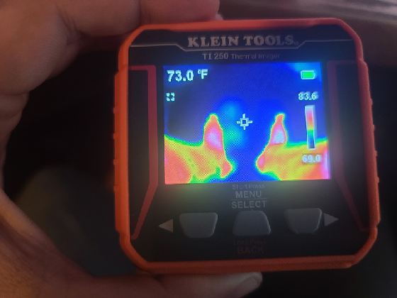
-
 If anyone already has a hobbyist drone you can get a jump on things - minus the detector - by mounting a FLIR camera. Or, there is the option to just buy an already equipped drone - DJI and a few other brands sell these. This makes it remarkably easy to find adits to mines and cave entrances as they stand out like dark blobs due to air temperature variance on hot days - it works best if you have a really good day-->night temperature swing. Finding undocumented mines sometimes will put you on top of gold. 🚁 https://iopscience.iop.org/article/10.1088/1742-6596/1368/3/032032/pdf https://www.flir-direct.com/product/flir-436-0020-00-vue-pro-r-radiometric-thermal-camera-with-9-mm-lens-for-drones
 -
 That would make for the lightest detector made. With a drone you could hunt for 20 min. It's a great idea except for the limited flight time.
 -
https://patents.google.com/patent/WO2021016649A1/en?assignee=minelab&scholar&oq=minelab&sort=new This is the most out of this world Minelab detector patent I've ever read. There is so much here, some very sci-fi like, I don't even know where to start. My takeaway is they seem to be positioning themselves for a drone based detector eventually (main details in this patent could be easily transferred to a drone based platform - IMU, GPS, magnetometer, heads up display, FPV, remote control, robotic/vehicle mount, etc) . That is 100% a guess. But in the meantime, there is some interesting, novel items in the pipeline that we might actually see on a machine in closer future? No clue if this is a coin machine or gold machine or if it's something they are actually working on right now or just trying to get control patents on such things for the future which may or may not arrive. One thing is for certain, Minelab is BUSY in the engineering department. A few of the highlights: Heads up display over glasses/head mounted display (aka augmented reality). Settings, target visualization, shading of detected/not detected areas (I asked for this specifically 5 or 6 years ago here, awesome to see it in a patent now). Plus a camera showing the coil (why would you need that if not operating remotely as from a drone?) The detector has a camera, IMU (accelerometer) and magnetometer to determine position with accuracy. The IMU tracks the position of the coil in real time in relation to both the ground and the target, and combined with the camera video feed will provide a "visual" of the target in the ground through the glasses/head display, as in form of a heat map which increases accuracy with each pass of a coil over the target. A GPS tracks the machine position to properly map the IMU/coil visual target data on the ground and let's a user see the mapping as they detect. This data is recorded for future historical use and can be shared. Centimeter accuracy with the visual target heat mapping. Potential operators/users include entities other than humans such as "robots" and "an AI (artificial intelligence) using a metal detector" and this line: "The metal detector may be handheld, mounted on a robotic arm of a vehicle or a robot." Wireless connectivity to computers and phones, transfer of files containing settings configurations from instructors or expert users Remote control of the metal detector through apps on laptops or phones Ability to upload maps, including detecting data, historic human activity, buildings, or other items that seem to indicate custom mapping capability Internet connectivity, potential control through the internet (again, why if not for a drone type device?) "Teamspeak" to other detecting members in the area wirelessly Visual/spatial discrimination Accurate depth measurement Synthesized audio mode, eliminating noise completely and allowing the detector to "recreate" a synthetic audio stream based on data from prior swings Delayed audio processing (enhanced audio) mode or real time audio mode, ability to seperate multiple close targets, reason for this I venture a guess why below ---> This patent actually seems to be describing a completely new method of RX in a detector. Which is actually similar in some ways to the wacky idea I had years ago of reducing EMI/ground noise by emulating a radio telescope array. But in this case they appear to be describing a fairly ingenuous method of doing something similar with only one coil by monitoring RX of the same target at different points in the swing (with the IMU tracking these points) and combining all those RX signals. In this way (and this is my guess, the patent doesn't explain this), you can form a sort of comparator, gradiometer, or interferometer to seperate the wheat from the chaff, so to speak. If that's what they are doing, then I find it to be brilliant. If not, then I just gave them one hell of an idea to patent for the future. That probably sounds like jibberish to non-engineers. But I want people to understand the brilliance in simple terms. Consider this: EMI is random. At any given point in your swing you'll get noise here, but not there. So if you compare two points in the same swing, you will hear noise one point but not the other point because the "zap" already ended. But you might hear a good target at both points in the swing since it's not random like EMI, it's always there in the ground. So, you can effectively eliminate EMI by comparing what signal is not there at two very close points in the swing, and keep the target since it's always there. Similarly, with ground, the ground changes as the alluvium changes since soil is inhomogeneous. But a target is still the target. So, a similar method can be applied to the ground. In theory, you could use ideas like this to essentially get rid of the Difficult type timings and keep your gains boosted high, and deal with EMI/ground in this way instead which does not require reducing sensitivity. A totally new, novel approach to RX in a metal detector. The audio processing is very slightly delayed because they are using that time to compare measurements at a few different coil positions before letting the audio processor signal that there is a target present. That's my guess. If that isn't what they are doing, then someone else should patent that and thank me for it later when Minelab buys it. Either way, they have something totally new in the RX department here. And the future of detecting looks bright and interesting to me still.
-

A Drones View Over A Goldfield
afreakofnature replied to karelian's topic in Detector Prospector Forum
Taking the pictures with the drones is not the problem, there are many apps out there than can lawnmower an area automatically. Some even allow you to use shapefiles from your GIS projects and kmz files if you want to draw your areas of interest in Google Earth and set up all the paths and overlap necessary. I personally stick with DJI's apps because they allow you to set the zoom angle if using the Mavic 2 Zoom (my work drone). The real problem is stitching it all together and it takes cloud based processing to really get anywhere, if you try to do it on your own PC it might take days even to process it all. With cloud based processing it might only take about 4-6 hours to stich together a 1/4 section's worth. Big name companies are DroneDeploy or Pix4D, but my employer won't pay for the subscription so I use OpenDroneMap Lightning. You can pay per map or monthly and it is way cheaper, not very user friendly, but Jason I am sure you could figure it out. For hacking your drone I used drone-hacks.com Again at your own risk of course. -
I probably will try that hack at some point. It seems easier than trying to fool the altimeter. Anyways, just wanted to comment on that since the question was asked about using a drone in the mountains in AZ and the Rockies, that's the main issue I had. In AZ I've been able to find high enough launch points, but a few times I've had to use the optical zoom after hitting the restriction. In the Rockies it turns into a real limitation though where mountains with prospects can be 4000ft+ prominence above the highest launch point you can drive to without climbing the mountain. When I bought a DJI Phantom like 9 years ago there wasn't really any mapping programs available, and I bought it to do my own high res aerial mapping for a Geocommunicator replacement website I made at the time (now defunct) called Virtual Prospector, with the idea of providing up to date high res aerials of the popular goldfield areas, for free. But I gave up on it because hand stitching the maps together and then georeferencing them manually was beyond time consuming, plus the distance limitations made it incredibly limiting (even with tons of aftermarket mods I barely got 1 mile in wide open Rye Patch), and at the time I had to hand attach a GoPro to the drone and couldn't get rid of the fisheye'ing entirely which made accurate georeferencing impossible even with days worth of hand correcting in photoshop. But I see a post that there are mapping software available now, and with the longer flight distances of these recent drones and awesomely high res cameras built in today, someone may try to do that again. Like Mylandmatters. Hint hint.
-
Besides using a hacked firmware update to beat the 500m limit, there’s another way you can do it but it’s unlikely unless you have a legitimate reason. DJ I can unlock it remotely, apparently: https://forum.dji.com/forum.php?mod=viewthread&tid=196674&mobile=2 🤔 What if you started the drone up in a barometric chamber type box or could cover the barometer port and give it a slight vacuum before it took off, would that fake it into thinking it actually took off at a higher altitude? It would be nice to not have to worry about the 500 m limit even if you are climbing above a 1600’ “hill” 🙂


.thumb.jpg.95344db3aeef0a4c6c73420daa366191.jpg)