Search the Community
Showing results for 'drone'.
-
 If anyone already has a hobbyist drone you can get a jump on things - minus the detector - by mounting a FLIR camera. Or, there is the option to just buy an already equipped drone - DJI and a few other brands sell these. This makes it remarkably easy to find adits to mines and cave entrances as they stand out like dark blobs due to air temperature variance on hot days - it works best if you have a really good day-->night temperature swing. Finding undocumented mines sometimes will put you on top of gold. 🚁 https://iopscience.iop.org/article/10.1088/1742-6596/1368/3/032032/pdf https://www.flir-direct.com/product/flir-436-0020-00-vue-pro-r-radiometric-thermal-camera-with-9-mm-lens-for-drones
 -
 That would make for the lightest detector made. With a drone you could hunt for 20 min. It's a great idea except for the limited flight time.
 -

A Drones View Over A Goldfield
afreakofnature replied to karelian's topic in Detector Prospector Forum
Taking the pictures with the drones is not the problem, there are many apps out there than can lawnmower an area automatically. Some even allow you to use shapefiles from your GIS projects and kmz files if you want to draw your areas of interest in Google Earth and set up all the paths and overlap necessary. I personally stick with DJI's apps because they allow you to set the zoom angle if using the Mavic 2 Zoom (my work drone). The real problem is stitching it all together and it takes cloud based processing to really get anywhere, if you try to do it on your own PC it might take days even to process it all. With cloud based processing it might only take about 4-6 hours to stich together a 1/4 section's worth. Big name companies are DroneDeploy or Pix4D, but my employer won't pay for the subscription so I use OpenDroneMap Lightning. You can pay per map or monthly and it is way cheaper, not very user friendly, but Jason I am sure you could figure it out. For hacking your drone I used drone-hacks.com Again at your own risk of course. -
I probably will try that hack at some point. It seems easier than trying to fool the altimeter. Anyways, just wanted to comment on that since the question was asked about using a drone in the mountains in AZ and the Rockies, that's the main issue I had. In AZ I've been able to find high enough launch points, but a few times I've had to use the optical zoom after hitting the restriction. In the Rockies it turns into a real limitation though where mountains with prospects can be 4000ft+ prominence above the highest launch point you can drive to without climbing the mountain. When I bought a DJI Phantom like 9 years ago there wasn't really any mapping programs available, and I bought it to do my own high res aerial mapping for a Geocommunicator replacement website I made at the time (now defunct) called Virtual Prospector, with the idea of providing up to date high res aerials of the popular goldfield areas, for free. But I gave up on it because hand stitching the maps together and then georeferencing them manually was beyond time consuming, plus the distance limitations made it incredibly limiting (even with tons of aftermarket mods I barely got 1 mile in wide open Rye Patch), and at the time I had to hand attach a GoPro to the drone and couldn't get rid of the fisheye'ing entirely which made accurate georeferencing impossible even with days worth of hand correcting in photoshop. But I see a post that there are mapping software available now, and with the longer flight distances of these recent drones and awesomely high res cameras built in today, someone may try to do that again. Like Mylandmatters. Hint hint.
-
Besides using a hacked firmware update to beat the 500m limit, there’s another way you can do it but it’s unlikely unless you have a legitimate reason. DJ I can unlock it remotely, apparently: https://forum.dji.com/forum.php?mod=viewthread&tid=196674&mobile=2 🤔 What if you started the drone up in a barometric chamber type box or could cover the barometer port and give it a slight vacuum before it took off, would that fake it into thinking it actually took off at a higher altitude? It would be nice to not have to worry about the 500 m limit even if you are climbing above a 1600’ “hill” 🙂
-
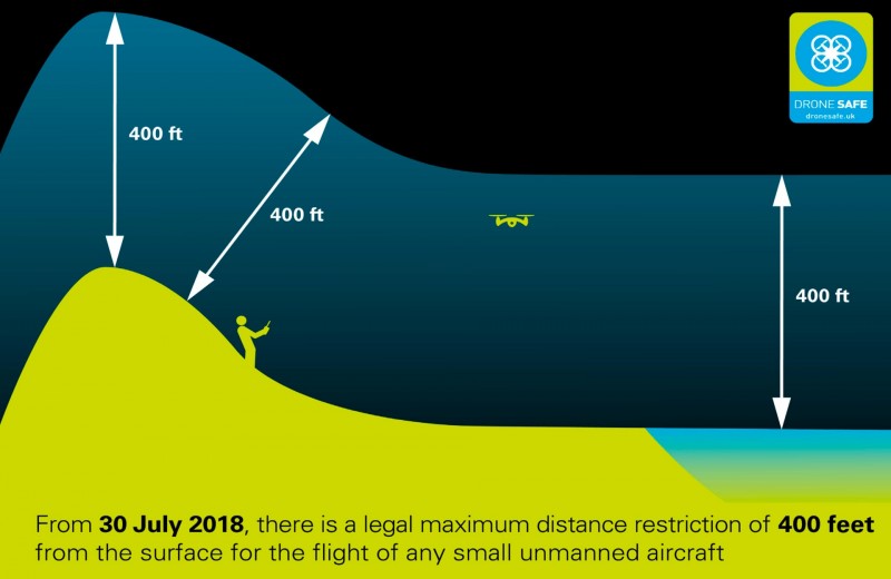
That may be a rule, but there is an absolute height restriction of 500m from launching point on the Mavic 2 firmware, so it's not possible to stay 400ft above the ground when flying up mountains. Unless I'm missing some setting that disables it, but I tried and couldn't find one, thus I have to find the highest possible point to launch. The drone does not appear to have any capability to measure height above surface, only altitude from original launching point (it probably uses an altimeter, doesn't measure distance above surfaces). It doesn't care if there is a mountain under you increasing height as the drone increases height, it only cares about how high from your launching point the drone is now. So, I can be 20ft above the surface of the ground the entire flight travelling up a mountain, and then hit the height restriction halfway up and it won't let me fly any higher to get to the top even though I'm still only 20ft above the ground. 1600ft isn't much, that's a hill not a mountain, so it requires finding a high enough point to launch from, which ends up cutting into the time saved by using the drone.
-
Personally I wouldn’t use any of the hack programs, they’ve been known to be unstable and some have lost drones with them. When flying in the US, and some other countries, one good thing is you are allowed to fly it 400’ directly above the terrain it is above or next to, thus you can be in a valley below a peak that’s 5000’ above you and still be allowed to fly 5400’ above your head as long as the drone is within 400’ of the summit or the side of the mountain. I find this rule actually allows me to fly it a very hilly area with terrain over 400 feet above me without any issues. On a Mavic 2 pro, you just have to accept the elevation limit warning if you’re going above 400 feet, no need to hack it- it will let you go as high as 500 m above you. One thing to watch for though is you can’t see what’s on the other side of a hill or ridge if you are below it, and sometimes aircraft like to fly close to them, so being able to see what’s around on both sides is important!
-
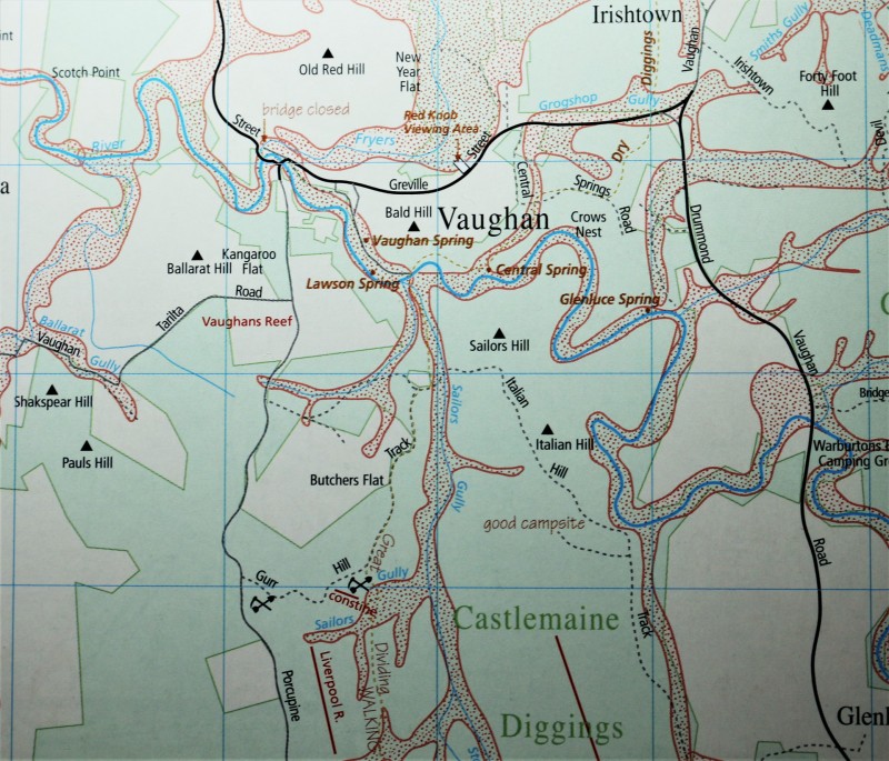
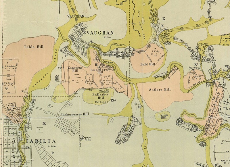
Just a bit of information on the Vaughan area as shown on old and new maps. The drone footage was over Ballarat Hill with the maps showing the same area.
-
A Drones View Over A Goldfield
afreakofnature replied to karelian's topic in Detector Prospector Forum
Hey Jason there are drone hacks that can remove that height limitation. I only have the Mavic pro that’s fully hackable. I’m not sure about full hack-ability on the 2. -
I have a Mavic 2 Zoom that I use in the Rockies and Arizona. It's been a real time saver scouting prospect, mines, and outcrop up in the mountains. I can see which have features that interest me, it's high enough resolution to tell the difference between ore piles and waste piles. Resolution is good enough that I can pretty easily identify outcrops. The zoom is actually surprisingly good too. The height limitation sucks around the high mountains, but I find a high spot to launch and combined with the zoom I've been able to see whatever I've sought. It hasn't been as useful to me in the desert flats. But I did use it to track thieves down, and you can see 2-tracks left by trespassers offroading around fences and see where they came from, or easily monitor thug compounds from the air, stuff like that. I've flown it almost 5 miles each way, so it's possible to cover quite a lot of land and distance as long as you have a line of sight between the control and drone (another reason I find a high spot to launch).
-
I'm using a DJI Mavic Air, mated to an ipad with the controller. I carry four spare batteries and spares etc Everything fits into a smallish Pelican style carry case to keep dirt and dust away. Because I always fly within visual range as per rules.. I sometimes use a spotter with binoculars, safe range out to 1 km, often much less. I use mining records and maps to find locations of interest. Google earth narrows it down a bit also. Finally once I have arrived on the goldfield the drone allows me to fine focus my attention on specific locations. I print out a hard copy mini map of areas I intend to search, then use a pen to mark areas of interest as I search that area by drone and on foot. A printed map works for me, digital alternatives on the ipad are used in camp to plan the days search. Research and planning.. analog and digital. Quickly learned that large metal objects like cars and hot mineralized ground play havoc with the drones electronic compass. Calibrate well away from the car and off the ground, then launch the drone from a tree stump if available.. The birds eye view helps me find the best parking spot and camp site. Quickly identifies the boundaries between private property and public land. Just a very useful tool in new areas. All the best.
-
Nice video Karelian, Have you tried using your drone and mapping software to create any high resolution maps yet? There are drone mapping programs out there both pay to use, and free to use, that can create high res imagery that can be overlaid in google earth etc. You can also create and overlay DSM's, Direct Surface Models, and DTM's, (Direct Terrain Models). Its just another way to visualize the ground, and can make spotting depressions and surface disturbances easier. Its a good solution for a closer overall look at a larger area, and then if it warrants furthur investigation, you could send the drone to the areas of interest to take video. All without leaving the truck.
-
A friend of mine who is a bat biologist uses a drone to look for open adits to find potential bat habitat, and I just recently used mine to see the extent of an old drywashed area. They provide very good high resolution images of hard to access areas, and definitely can be a benefit when surveying a large area more quickly, but they won’t replace boots on the ground.
-

A Drones View Over A Goldfield
Cascade Steven replied to karelian's topic in Detector Prospector Forum
Karelian: Thanks for sharing. You have brought up a good point that this tool can save a person a lot of time and wasted effort in a new area. Do you care to share any details about the brand of drone you use and why you chose it over other brands or models? How long have you used this technique? I am curious if anyone has tried using a drone in the Western US, in such areas as the Sierra Nevada, Arizona desert, or wooded areas of the Cascade Mountains, Northern Idaho or Montana? If so, I am very curious of their results and experiences. -

Battery Depletion On Simplex
Germanrazor replied to Germanrazor's topic in Nokta / Makro Metal Detectors
Thank you for the information. I was wondering since for my agency I oversee a UAS (drone) fleet and they use LiPo batteries and our manufacturers tell us to never store even overnight if it can be helped the batteries at 100%. In fact, they suggest storage at 30% for the longevity of the systems batteries. This is a nightmare as we may have to fly at a moments notice and arriving on scene then having to charge a troop of batteries for another hour give or take is sometimes killing daylight as we say. But the manufacturers stand behind this and the batteries are what they call intelligent batteries < which I laugh at. Good to know CG. -

Minelab GPX 6000 With Geo Sense Pulse Induction
jasong replied to Steve Herschbach's topic in Minelab Metal Detectors
I'm not sure they are getting rid of the background threshold, or maybe making it easier to run a lower threshold or without one if a person chooses, or just adding more control with timings that means you can find the balance between threshold levels of EMI, ground, and targets more precisely and do whatever you want with the background drone we call "threshold" in general. It's really hard to make sense of patent legalese exactly. But it does work on a high end detector - I run my GPZ with almost no threshold so that 95% of what I'm hearing are just the tiny variations which are either EMI/ground noise that jump barely above my threshold level, or good targets. I bump the threshold up just barely above silent though so I still hear the faint background warbles, just not the needless (in my opinion) constant threshold drone. I do pretty good with this style. I see no reason to listen to ground noise personally, my eyes do much better there. This is one reason I liked the 8" X Coil. I could bump up the threshold 8 points and still maintain a nice quiet stability I'm used to. Whcih means to me the coil has a lower noise floor, smaller target signals come through, and I can also run higher gains as a result. Same idea as this invention it sounds like to me. The perfect detector would make no noise at all except on a good target. EMI and ground would be completely silent, this there would be no need to listen to a constant threshold drone if you had enough control finesse to keep the threshold at the perfect balance between EMI/ground noise not coming through, and targets coming through which are above that noise floor. If I'm understanding this patent right, it attempts to embody this sort of detecting theory and allow users further control over it. Bruce Candy has another recent patent too (this one is Wahlrich) which sounds potentially like a new GPZ. But that patent lost me halfway through, it's a difficult read. But it's main focus is on a method to ignore the X component and start sampling way earlier, which means sensitivity to ultra tiny gold among other things. I could be misunderstanding that one too though since it kinda sounds like a PI/constant current hybrid and I'm still not sure I understand if ZVT is different than that or not haha. Detector tech is growing beyond my brain's ability to grasp it these days. -
So I recently retired in January. I've been having a great time touring the western states in our RV, flying my drone in some really interesting places. Great hobby. My dad always had a metal detector in retirement, he found over 10,000 pennies, ha! But I'm more a history buff and would visit locations that have some history to find "who knows what", maybe some nuggets! 😉 So I thought I would give it a try and invest in a good detector, something state of the art, so I don't have to buy another one very soon. I built a kit metal detector in the late 60's, played with it for a few months, and then moved on to motorcycles, which was a bit more exciting at the time. However, the technology has come a long way since then, and I don't ride motorcycles anymore. I do have an RZR side-by-side that can take me to remote places to detect, which is part of my plan. I'm still shopping for the right detector, that's why I joined this forum, to get the straight poop to make an informed decision. Looking forward to learning a lot here, like I have in my drone forums.
-
Hello! I’d like to hear from some folks experienced with the GPX detector sounds. There is a lot of talk out there of how much quieter these model detectors are over their predecessors, but I am not so sure. I have found that hot rocks my old detector would scream on are ignored, though as for noise, there is a lot of it. I’ll do my best to describe what I hear in a relatable way, a bit deeper than the general listening to little harmonicas in the headphones. To begin, I can absolutely discern a nugget response. I am lucky enough at this point to have found nuggets every day detecting with this detector since I’ve owned it. But questions, they have arose and I hope that by sharing my curiosity and (hopefully) receiving feedback, I may learn to use this machine more effectively and shine more light into the world for other GPX operators. I thoroughly believe the ground I have been hunting is quite hot, maybe even on the severe side. I have not been able to run my detector very quietly at all. Don’t be too harsh on me for saying this, but I have not tried running it in Sens Ex yet. Fine Gold is finding me nuggets fairly easily with a Gain of about 8, Stab about 10, Tracking fast, and Motion medium. I tried out Enhance once and it didn’t seem to make a difference, so I stuck with what’s been finding me nuggets (3 trips-14 nuggets). The noises, I’m looking for some confirmation or identification if you can deduce my rough descriptions. First I suppose I will start with the threshold. This sound I believe is very obvious to pick out, to identify it I simply adjust the threshold up until it’s loud and obvious, then I turn it down until it’s hidden and then back up until it’s quiet yet something I’m able to focus on. Now sometimes this very faint drone will go blank for moments, but so far I have not found an instance of it being repeatable. What’s happening? Other times it seems like some sort of audio boost kicks in without any changes in volume or pitch, almost like just another layer of the same sound is being superimposed over the threshold and noise, also no instances yet of repeatability. What’s this? Second, I’ll ask about ground noise/ground balance. I seem to be getting quite a bit of noise from the detector which I am assuming is, the infamous ground noise. I’d describe this noise as a chatter and all the likes of little burps and chirps that are not repeatable. Now I assume I could quiet all this down via settings, but again, I’m finding nuggets so I’m willing to endure for now even with the awareness I may be missing nuggets at the same time. But I think my big curiosity with this is the fact that sometimes it seems like I can’t ground balance. I even am careful to gb over multiple spots in case I was trying to gb over a target, but it just won’t smooth out. Though it seems to smooth out once I start going even though it wouldn’t during gb. Is this common at any level? I made a sorry attempt at a specific balance once, but I was finding nuggets still, so I haven’t really been diligent about pulling off a good Sgb. Now my last noise question is about EMI. I can identify when I’m getting false bump and vegetation signals, but what I’m thinking of as EMI can be really bothersome and seemingly malicious! Is EMI the totally false booming signals that sound like a target but are not repeatable and also don’t really match up with my sweep speed? I’ve tried playing with some manual adjustment after doing a tune, because sometimes this noise that I’m thinking is EMI is so bad that I’ll do an auto tune every five minutes or so. I wouldn’t really think the area I was in would have so much EMI. Maybe the Sun has been a bit more excited lately??? I know I’ve just asked a lot and I have even more questions than this, but if anybody would be willing to even partially help out. I’d be very grateful. I’m very interested in the way that the GPX settings work and what’s actually going on even deeper than what’s described in the manual. So if there is any literature out there with some more depth into this machine, I’m asking to be guided. I absolutely love the GPX and I want to get a couple aftermarket coils for it now that I’ve seen how it is with the stock coils and reading about how much more of a performance boost some of the coils out there can give it. Thank you!!!
-

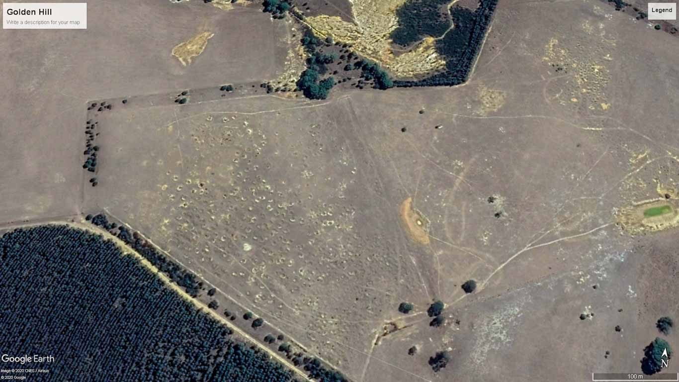
Research Goes Beyond Google Earth.. Bulldog Diggings
karelian replied to karelian's topic in Detector Prospector Forum
Getting better using Google Earth, better images now. In the future, when not on lunch breaks; I'll attempt to use a better camera, incorporate decent video and audio etc. I've traded for a DJI MAVIC AIR, so after a bit of practice I'll hopefully incorporate drone footage in the not too distant future. Proper video editing remains the final challenge. The image from Google Earth shows the Bulldog area on the top, Golden Hill diggings visible on the open country below the Bulldog Hill, finally the plantation in the bottom left corner. I drove through the plantation and the ground has been worked with machinery to prepare for the trees. So no old working remain visible. Neat rows of trees with scattered quartz etc under their shaded canopy. Area is worthy of a revisit.. All the best.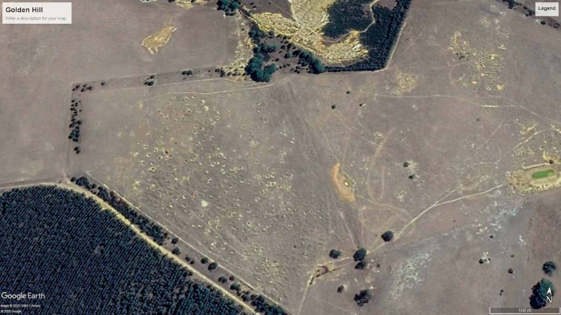
-
I have the same problem, I'm looking for a good drone for photography. I found information about drones with good cameras on the Internet, but they cost too much. What budget options do you know? I looked at https://buyersimpact.co.uk/ good reviews for a couple of budget options, but in my city at the moment there are no such options. I can only wait, because I can't afford a super-expensive drone:( I hope Christmas discounts will start soon, and I will be able to afford something more expensive, in this case, this holiday will definitely be possible for me:)
-
Hello All, I am new to metal detecting and looking for some advice. Metal detecting is something I've always wanted to pursue as a hobby, but just never really committed to making the investment. I have a few detectors in mind Minelab Equinox 800 or 600 and Garrett GTI 2500 also open to suggestions but those three seems like decent choices for intermediate. My question is how deep can a standard metal detector detect? There's a bit of backstory here but as a kid, I watched the movie Encino Man. For those unfamiliar the movie is about two teenage friends digging a hole in their backyard for a swimming pool. Hilarity ensues when they unearth an ice-age caveman the rest of the movie is a little fuzzy, but they acclimate their new friend to the modern world. Anyway, after watching this movie I convinced my mom to let us dig a giant hole in the backyard! For some reason she agreed. Probably because it kept us busy and out of the house. So flash forward a bit we have a decent sized hole dug in my backyard. Keep in mind I'm 9-10yrs old (so things seem much larger) but as I remember it the hole was at least 8ft x 5ft and probably 3-4ft deep. This was how I spent my summer vacation, everyday I would go outside and just dig! Then, one morning I hit something! Excited, I ran into the house to inform my mom. What I hit was the side of a metal trashcan. The sort of trashcan Oscar the Grouch lived in on Sesame Street. The can was buried sideways and I brushed away enough dirt to tell it was trashcan but the can was still completely buried. My mom freaked out and forced us to fill the hole (whatever was buried that deep was not meant to be dug up!) After 25yrs the house is now mine and the thought of what could be buried there still intrigues me (hundreds of gold bars perhaps 🤔). The home was constructed in 1940, but built on the property of another home which was constructed much earlier probably 1910s. The older home has been destroyed for years and was demolished to built 8 townhouses/condos. However, the old lady who lived there had been in the house since birth and died at age 98. The townhouses/condos were built in 2007 which suggest a 1910 or earlier date for that home. The old woman did tell us about the area when before all the countless other homes were here. How you could see in any direction for miles. Now you need a drone for that and its nothing but developed land for 50-60 miles in all directions. If I had to guess a date for the trash can 1930s era would seem to align well. The short version, there's a metal trashcan in my backyard that I would like to relocate and excavate. However, I am not sure how deep the object actually is at most I would guess its 3ft to maybe 3.5ft. Could a metal detector locate a large object at this depth? I've been searching online for an answer to this question but cannot find any conclusive information. From what I can gather the detect-ability of an object varies considerable and seems based on the objects size. Most coins, for example, are fairly small and anything beyond 30cm (1ft) is probably on the edge of not registering a signal? However, if the object is larger the detectable depth will increase? So if you're searching for a pirate style treasure chest it could be buried much deeper and still be detected.
-
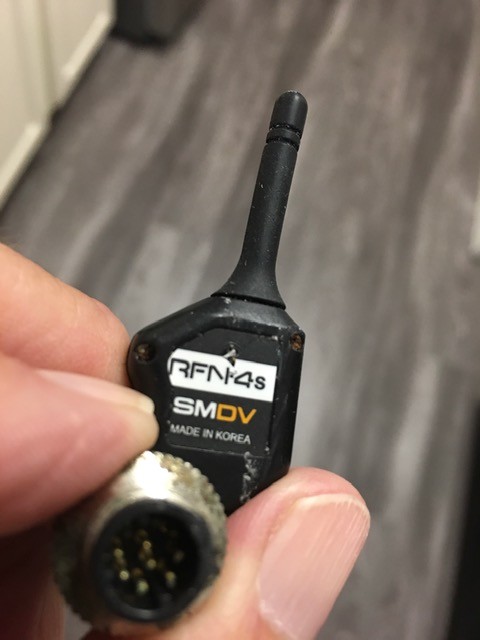
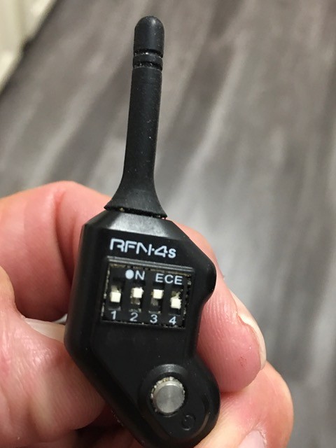
It never ceases to amaze me at the things we dig up in the sand at the beach. I tend to call them "odd" unless I dig up another like it. That being said, I need one of you electronic specialist to ID my latest "oddity" that I dug yesterday while still looking for my first AG AU. I have attached 3 pictures and you can gage the size as I hold it in my fingers. It has 4 dip switches on one side and a 10 pin mail connector on the other. And it has a small antenna on it. This is a new one for me but by my own admission I am electronic connector challenged. Any good answers out there? RC, radio, drone? An inquiring mind wants to know. I am sure it is only a matter of time before I dig another as that seem to be the case on So Cal beaches. Thanks in advance. Joe

-
Simon do you have one of these? or have you set up the QED on a Drone already
-
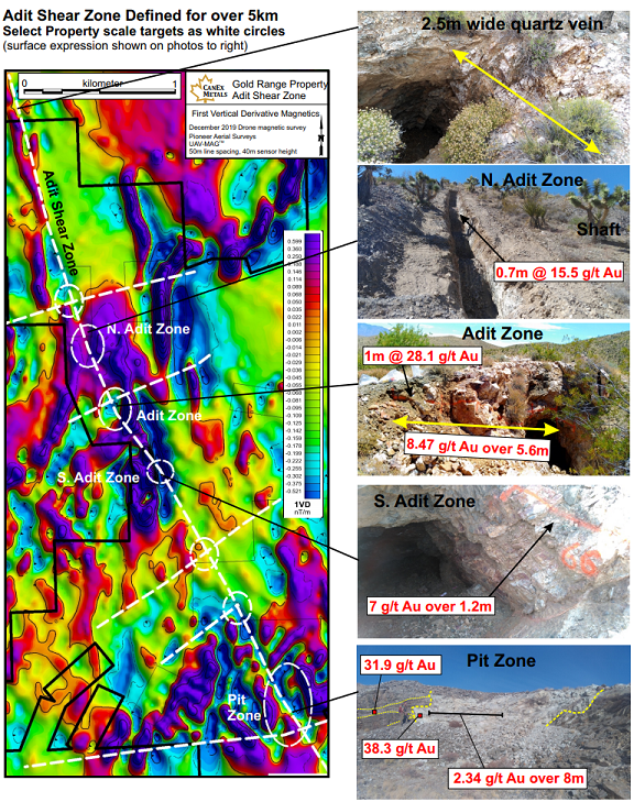
They are pretty useful for large scale big picture type stuff. Last year we hired out a company that does these to fly magnetic drone surveys on a commercial project I am involved with. I own the initial claims. It's now 130+ claims. Drone mapping allows us to cover a quite extensive area and get a good idea what is buried and where to concentrate future soil and outcrop sampling efforts. I am limited in what I can say, but this is from a public press release so this is already public and shows how you can concentrate prospecting efforts in specific places in the large scale with mag surveys. The drone surveys are only flown at 100ft or so and so resolution is high. I know the initial post is tongue in cheek, but there may actually be some good use for flying magnetic drone surveys for prospectors who are targetting buried hard rock trends. I would love a little magnetometer that hooks up to my Mavic Pro, flies a preprogrammed grid, and outputs a nice chart like the one below.
-
12, I think? Whatever default volume was, I've never changed it from factory on my 2nd GPZ. My hearing is pretty good and I've never had to use a booster, I still have a ton of volume to go up on the GPZ itself if I needed it, but I've never felt I needed it. Much bigger problem to me is audio fatigue where my brain starts selectively ignoring stuff when there is a too much of a threshold drone and too many spurious signals. Not so much using smoothing as a volume control as a way to make the audio cleaner so I can detect more ground, faster. Not by swinging faster but by concentrating on spending my time digging signals with a high probability of gold, versus spending time digging signals with a much lower probability of being gold or spending time stopping and analyzing signals that are largely just ground noise/EMI. Do I miss stuff? Yes. I am not in the camp that I need to hear the ground under me. I understand it's not PC to say this as most the experienced guys generally say they want to hear how the ground changes under them. My eyes tell me what I need there though and I don't need to know if I'm over hot or mild ground as I move. More important is for me to look at the geology and topography around me. I want a quiet threshold so I can pay attention to the world around me and just have targets jump out at me, it helps me stay on the gold more than listening to wether the ground is varying. I do understand what you mean about the start/stop nature of the threshold, but that's exactly what I'm going for. I like my signals to be sharp and definite, and my threshold to be minimal and in the background. I know I occasionally miss faint threshold variation stuff as a result, but my experience is it pays better to spend time hitting more ground than spending time chasing these types of signals. I've done some experimenting on in-situ targets here where I detect, and I've found a big difference between running at 9 gain and 19 gain. Low gain misses a ton of tiny blips that are to me very definite gold targets in my smoother, but high gain settings. I have some video of almost exactly this somewhere, might be on my computer at home and I'll look when I get back. Turning gain down, but thold up and smoothing off could not not hear a target I had just found with smoothing on, thold around 12, and gain at 20. In the video it ended up being a 7 gram target in the wall of a wash, maybe I have it on my GoPro here, I'll check tonight, I gave up on posting videos last year though and lost track of all the stuff I was going to compile. I've experimented similarly before on in situ targets and it generally shows me the same, higher gain/lower threshold hears things that lower gain and higher threshold/no smoothing miss. Maybe it's just my conditions, maybe it's my lack of skill or lack of patience, but this is what works best for me here.


.thumb.jpg.008984156b596a0063f90b0d7fbc295b.jpg)