Search the Community
Showing results for tags 'geology'.
-
New Detecting Location. Bit Remote Though - - -
jrbeatty posted a topic in Detector Prospector Forum
NASA’s Mars 2020 will land in Jezero Crater, pictured here. The image was taken by instruments on NASA’s Mars Reconnaissance Orbiter, which regularly takes images of potential landing sites for future missions. On ancient Mars, water carved channels and transported sediments to form fans and deltas within lake basins. Examination of spectral data acquired from orbit show that some of these sediments have minerals that indicate chemical alteration by water. The sediments contain clays and carbonates (courtesyNASA/JPL-Caltech/ASU/WUWT) Can't wait to wave a coil over those outwash gravel deposits. At least there's no BB's and rusty nails, could be a few metallic meteorites though - - - Luckily, I've got an old hot air balloon under the house somewhere - and warm winter woolies, so I'll see all you good people later. Wish me luck - - - I offered to take Reg along on the expedition - but he declined the invitation - can't for the life of me understand why? Not like him at all ;<) -
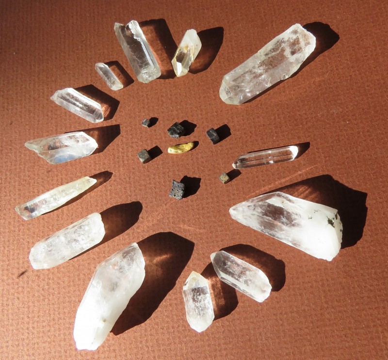
Though I don't prospect, I'd like to share this - HH and enjoy! https://www.nationalgeographic.com/science/2019/05/worlds-rarest-form-natural-gold-reveals-secrets/
-
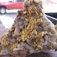
 Many believe that the nugget gets rounded by it tumbling about. I have a large specimen that is flat on one side and I've always believed that it is that way because other objects passed over it as it stayed in place. This article confirms that for Blackwood, Australia and says: ‘A feature of many of the goldfields of Victoria was the finding of large masses of gold nuggets. They varied in size, and were not confined to any particular class of washdirt, nor with any regularity as to depth, but, from their disposition in restricted areas, certain belts can be regarded as typically nugget bearing. On account of the soft character of gold, nuggets of any size are always well rounded. This is due to the attrition of material passing over the nugget rather than rounded by rolling action. Many of the large nuggets had one side relatively flat, while the other was well rounded. Some of the nuggets were coated with oxides of manganese and iron; several had quartz attached to them, while a few were of ragged and roughly crystalline appearance.’ http://www.blackwoodpublishing.com/blackwood-eagle-nugget-found-1931/
 -
Hi all we are looking for information on different types of gold ground producing detectable gold / no gold panning I did not go around the whole forum but I see that there are prospectors from all over United States, New Zealand, Australia ?? the more information we have (precise) from different sources / better it will be ... so, among you who already find gold do you know the percentage of Fe2O3 and Fe3O4 on your hunting grounds if you have answers, please specify if the terrain is easy or difficult to find gold we are developing a testing ground with mineralized lands of different origins the goal being to have the widest possible range of difficulty to improve performance .. all information will be welcome Thanks !
-
Enjoy! ? Ig
-
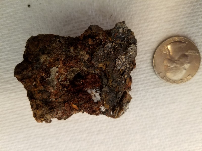
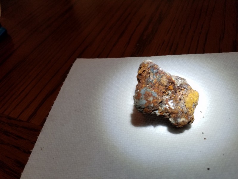
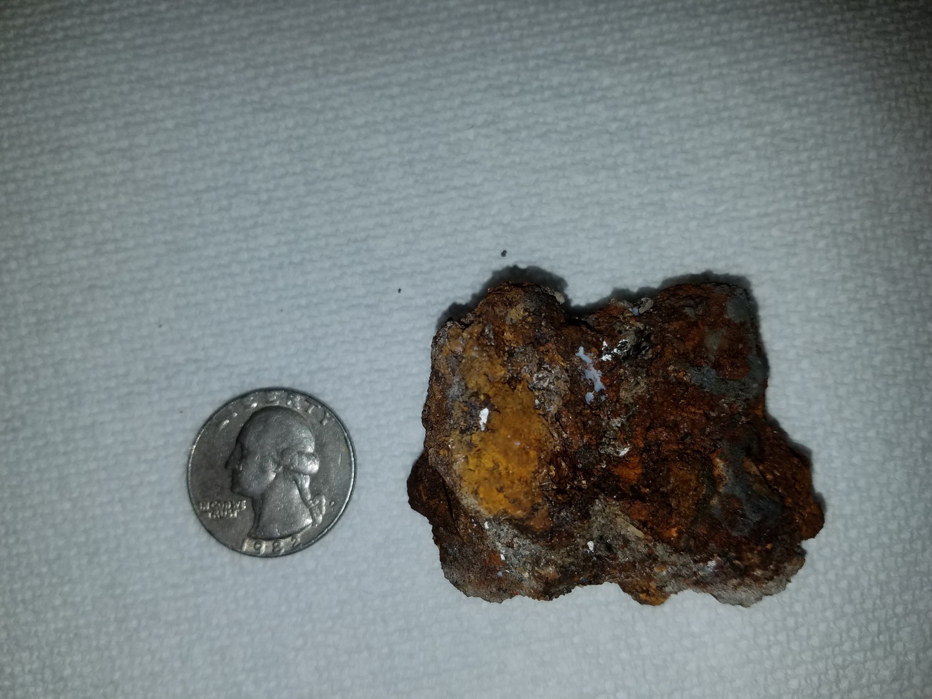
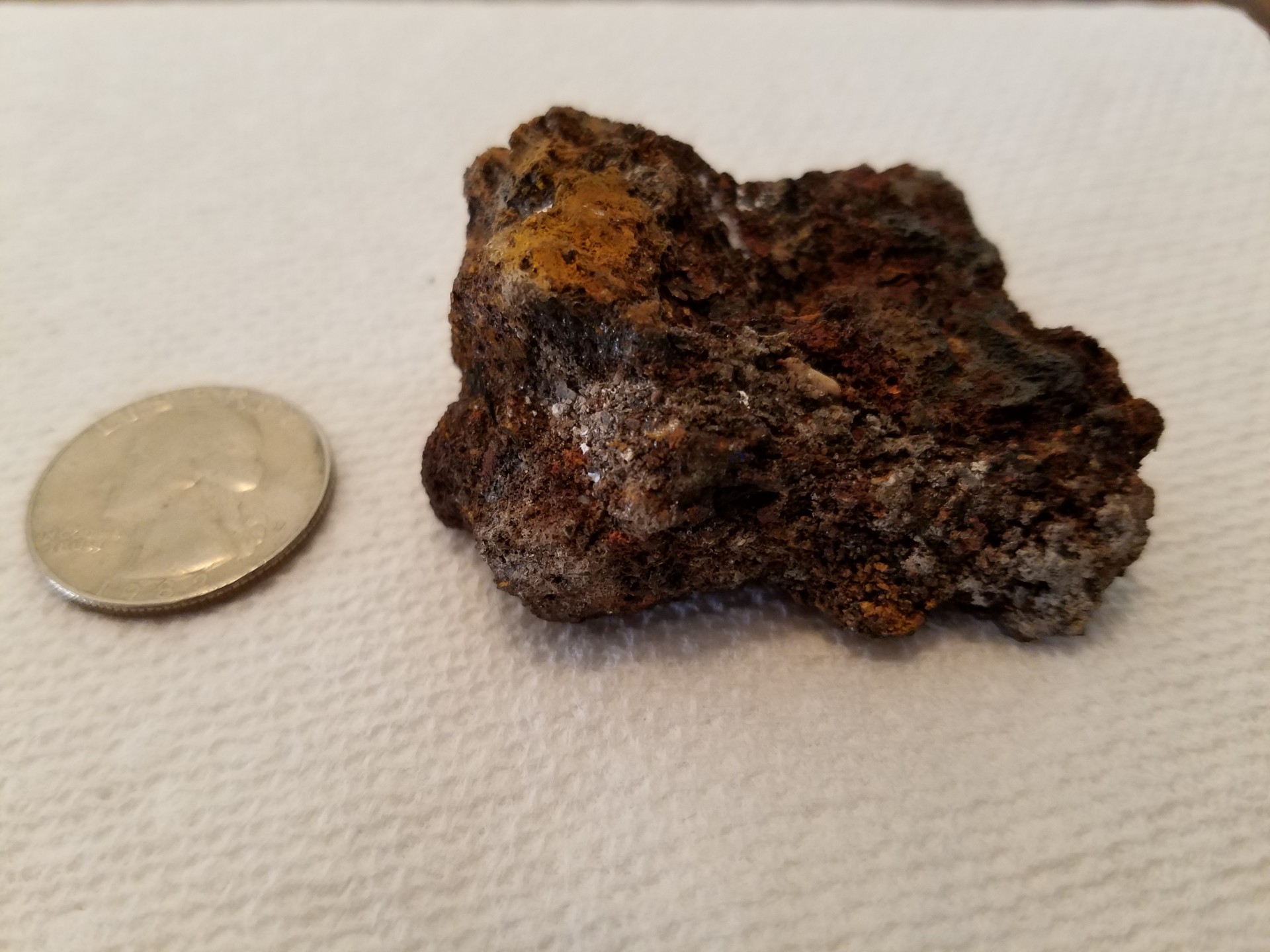
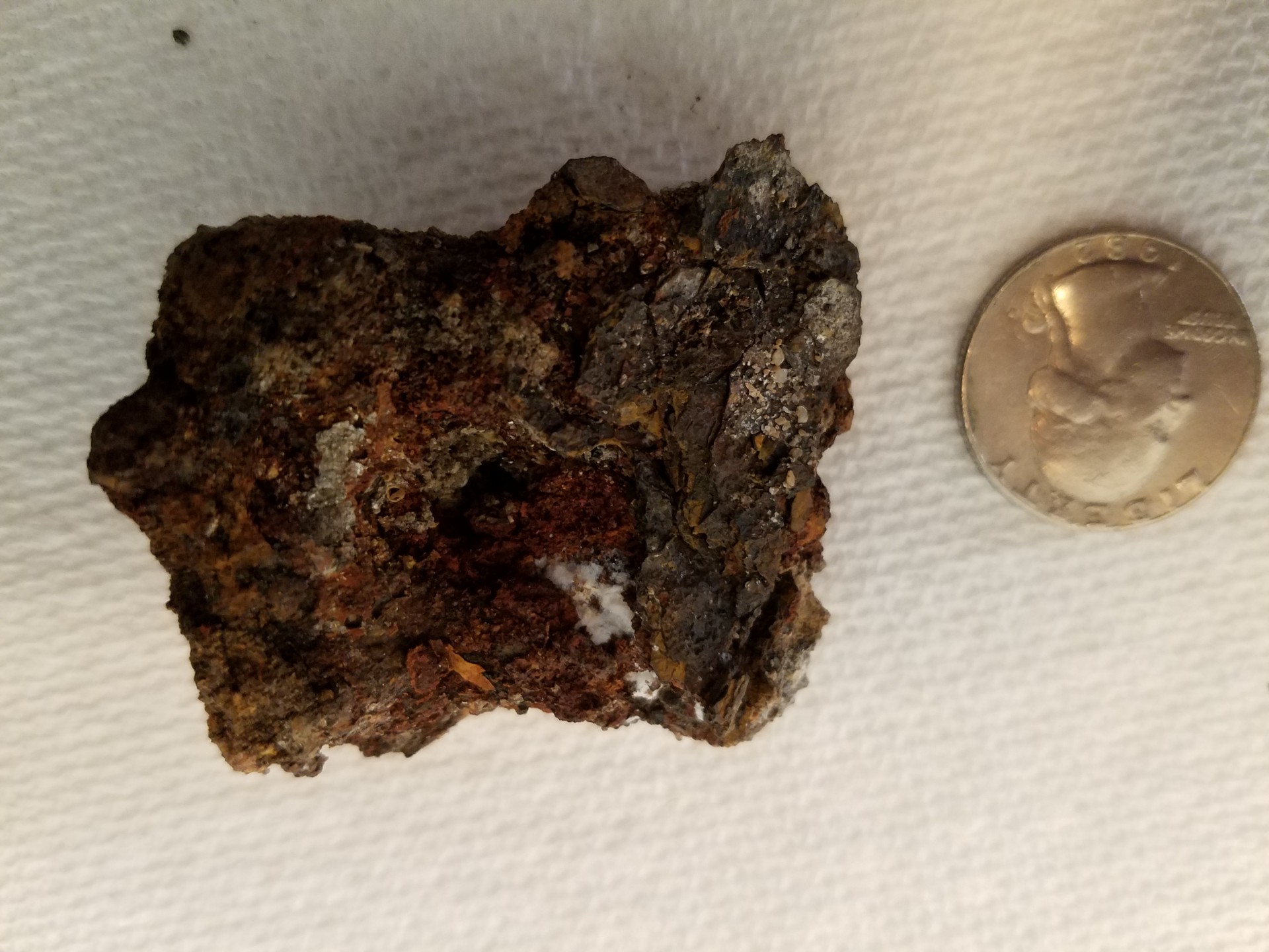
I posted this over in the meteorite forum, but after some research I wonder if the mystery rock I found is Limonite. I found this at a Fort Lauderdale beach yesterday, pretty far away from the water at a volleyball court. It was about 10 inches down in the sand, and my PI metal detector locked on to this pretty easily. I have a Pro Find 35 pinpointer, which makes a different sound for ferrous items, which it does on this rock. It weighs about 76 grams, seems unusually heavy for its size, and a magnet does stick to it. Before I send it anywhere for analysis, I was wondering if anyone here might have any thoughts? Possible Limonite?


-
Do you ever question yourself, am I in an area that even has gold? It isn't always true, but if you see these indicators together you are probably not far from gold.
-
Ive attached a lidar map of the main area i prospect. Id like to get peoples knee-jerk reactions on where they would swing a detector knowing large nuggets (they have generally been very crystalline with a few specimens found) have been found in the creek. So what would be your number 1, 2, and 3 spots to focus on. Ive detected around a good bit and have yet find anything outside of the creek, but i want to see if im missing something obvious. lol Search Area 1.pdf
-
 In light of the recent release of the Minelab Equinox, and expected release of competitive products I've noticed various posts across the Internet of tests/reviews/comparisons of detectors on fresh and saltwater beaches with "Black Sand". But there is only a 50/50 chance that the beach "Black Sand" you are looking at is iron bearing "Black Sand". The other possibility is that it is plant matter that has decayed and been ground into fine powder by wind and wave action. Those in areas where Bog Iron is produced or those Southern Red Clays have to deal with sands that are iron bearing but not necessarily Black in color. Some of the hottest sands I've ever seen were Purple in color. To know whether the "Black Sand" is the bad kind(iron bearing) you need to test it, a simple magnet can help or a detector with a ground type meter. Unless a tester/reviewer has verified the black beach sand as iron bearing I would be skeptical of the results.
 -
Is it worth while detecting old deep lead mullock heaps? The heap I have in mind comprises of granite and ironstone rocks and kaolin clay.
-
Ok, this is going to give away my lack of real-life gold hunting experience. I've heard two different responses to this question so I'm left a little confused and hoping someone can clear this up. My question is: In most cases would the larger pieces of gold travel less and be closer to the source and the smaller pieces travel further away? (this is what I would think would happen) On the few occasions if found patches I've found the larger bits were closer to the shedding reef but have sometimes experienced the complete opposite with some of my bigger finds a lot further down the slope. (maybe two different sheddings? ... they say that a reef at one time may have been a lot higher, so gold shed at different intervals may be in different spots) For those that have found patches what has been your observations? Cheers Jin
-
 I am going out on my first detecting trip I think I'll be using an xterra 705. The area I am interested in is south western idaho generlly around silver city the war eagle mine and a few other spots up there> I still have alot to do in terms of research and permission. I t looks promising , rugged and well who knows? Does anyone know if this is what you would call a mineralized soil area? I may drive on over to the Jordan valley area of oregon as well. any knowledge on this location? Thanks in advance.
 -
I would like to know what exactly is minerlaization, What kind of minerals? are they all iron based or mafic? what about other things? I am considering the purchase of my first detector and looking at a used xterra 705. I know that VLF are limited in heavy minerlized soils/Rocks so I am trying to find wha th elimits of this detector would be. I plan mainly to hunt for gold nuggets > while I would like a PI I don't see any that re reasonably priced for a first detector. What thoughts do you have?
-
 I have a question??? If gold is found on some beaches all over the world could it be found in sand under the tundra in Alaska????
 -
T When detecting with the detector what mineral floor of the soilHow do we know which layer of mineral soil is in the detection with the detector? Are there charts or charts showing how much the mineral is penetrating the depth of the soil?
-
-
I have heard Dr. Erik Melchiorre give a talk on finding nuggets in Quartzsite that came from bacteria. He said he had been to Australia talking with someone there about it so this might be the group. It is an interesting discovery. http://www.abc.net.au/news/2018-01-22/how-your-old-phone-is-a-tiny-gold-mine/9330994 Mitchel
-
Hey Steve.... How ya doin with the earthquake swarm? http://www.rgj.com/story/news/2018/01/17/south-reno-earthquake-swarm-over-230-quakes-and-counting/1041466001/
-
am not into geology ,,,,i dont know hard rock mining either .....what i know 5 types of lava .....what,, where and how would u look for placer in this lava or this area ??? ......this is in a gold rich area ....could a gold bug 2 find anything ?????? any information would be helpful thanks
-
 Steve, I am curious if you have ever detected land slides, debris flows, translational slides, areas of mass wasting? And if you have did you find any nuggets.
 -
The USGS just released their latest Professional Paper 1802 Critical mineral resources of the United States–Economic and environmental geology and prospects for future supply. This thing is a monster! 862 pages and a 170 Mb download. That is a big download for a lot of people so we shrunk their bloated PDF down to 30 Mb. It's got all the stuff the bigger one does but the graphics are scaled down to web user size. You can download the full 862 page report directly from Land Matters. This huge report is fine in itself but to really understand what's in it we figured a map of all the locations would help. You can load up the Critical Minerals interactive Map right in your browser and study it along with your book. We've added the mines of the world as well as some basic base layers so you can compare the report locations to known historical and current mines. We'll be adding more features to that map soon. If you need to print out the book in it's original high resolution form you can find it at the USGS Publications Warehouse.
-
I wanted to start this thread because in all the locations we all detect whether it is in western US or any where in the gold fields of Australia there is at least one spot that can stump all of us. This would be the spot that maybe we go and we know there has been good gold found there but for some reason we get skunked. This could be a spot that the geology is different than places we have success finding nuggets detecting. As we all know what's going on with the geology where gold is detectable is different everywhere. Knowing how the gold got to an area is very important for our success. Here is an example . In one area I detect Libby Creek the gold is on and in the bedrock as well as spread out thru all layers of gravel as though sprinkled from a salt shaker. I have this figured out. Another area you will not have much luck finding nuggets unless you are on the bedrock. Period. That is where the gold is in that area. The one exception to this in this area is hunting for specimens around lode mines. There is one place a friend of mine and myself have been going to detect for nuggets, each of us for a period of about 14 or 15 years and we both get skunked every time. I have held a 4 ounce nugget from this area found with a detector. So with this knowledge and knowing that three guys found 300 nuggets in this area in one summer, we keep going back. This is the eternal optimism of all of us who detect for nuggets. This area that stumps my friend and I is all granite the rock outcroppings the loose rocks on and in the ground are granite. The bedrock is granite, even the regolith on the bedrock is all granitic in make up. So I thought maybe if we all share info on the geology in each of our nemesis localities, perhaps someone out there has knowledge how to hunt these locals. I am not asking anyone to divulge the name and location of these areas, just the clues you have learned dealing with the geology in relation to the gold that led to success in similar sitiuations. Lets try putting our collective minds and knowledge together to help each of us. What is your nemesis spot. Maybe we all can help each other. Try to give all geological info that you know of too figure out the clues of where the gold might be hiding.
-
-
Something I heard recently, was many prospectors don't detect lower than a certain sea level in a given area. Well, that was news to me and I said to the guy that told me "at what level would that be?" He said different levels for different areas. ( he said around 260 meters above sea level for the particular area we were in at the time) I then meet someone else who said: "yes that's something that some people follow." He explained his theory but unfortunately, I only grasped half of what he was saying. I've been thinking about this and wonder why the levels one would detect at would matter. *Originally a lot of Victoria was underwater (ocean). I'm not sure if all the sea water had departed from the area before the period in which gold was being formed in. The only reason I can think of, is if the water was still present then as the gold got washed off the hills and came into contact with the water it slowed down immensely and the gold dropped out and stayed at that sea level. Just like when a river that's skinny widens out the flow slows down and the gold drops out. The other idea and along the lines of what the second guy thought was that gold cools at different temperatures than other metals and when it reached the level that was covered in water it cooled down at that level and formed in the host rocks. Anyway, hope this isn't a stupid question and someone could explain it a little better. (I asked someone else and never got a reply so I thought id ask here.)
-
 Geology and Gold Mineralization of the Gold Basin-Lost Basin Mining Districts, Mohave County, Arizona By TED G. THEODORE, WILL N. BLAIR, and J. THOMAS NASH With a section on K-AR CHRONOLOGY OF MINERALIZATION AND IGNEOUS ACTIVITY By EDWIN H. McKEE and a section on IMPLICATIONS OF THE COMPOSITIONS OF LODE AND PLACER GOLD ByJ.C. ANTWEILER and W.L. CAMPBELL 1987 U.S. GEOLOGICAL SURVEY PROFESSIONAL PAPER 1361 The Lost Basin district contains a wide-ranging group of placer and lode mines in a belt lying between Hualapai Wash on the west and the Grand Wash Cliffs on the east (fig. 3). It extends from the Colorado River at the mouth of the Grand Canyon southward through the Grand Wash Cliffs for a total length of about 32 km. This district, although much larger in areal extent, has not been as active nor as productive as the adjacent Gold Basin district. The principal gold veins were discovered in 1886, and the production of the district was reported by Schrader (1909) to be "many thousand dollars," chiefly in gold. Placers apparently were first worked in 1931 and resulted in a minor local boom. However, recorded pro- duction in copper, gold, and silver during 1904-32 was valued at less than $45,000 (Hewett and others, 1936). The King Tut placers, discovered in 1931, were the most important placers in the Lost Basin district. Systematic sampling of the King Tut placers by G.E. Pitts in 1932. delineated approximately 90,000 tons of indicated reserves and 250,000 tons of probable reserves before mining operations on a relatively large scale began (Mining Journal, 1933, p. 10). All of this was confined to approximately one section of land. In the last four months of 1933 the King Tut yielded 117 oz of gold (Gerry and Miller, 1935). By 1936 the gold output from the King Tut was 450 oz, which represented the bulk of the entire pro- duction from the Lost Basin district. In 1939 Mr. Charles Duncan placered 13 oz of gold in 16 days, using only a sluice box and wash tub, near the King Tut placers (Engineering and Mining Journal, 1939), whereas the King Tut placers themselves were only worked intermittently until 1942. Eventually, placer mining of unconsolidated gravel from the upper reaches of present-day arroyos extended across approximately 25 km2 in the general area of the King Tut placers (Blacet, 1969). Nonetheless, by 1942 no additional production was recorded from the Lost Basin district. However, in the middle and late 1960's several small operators using dry washers were active intermittently in the general area of the King Tut placers. These washers were powered by small portable gasoline motors. Because of the surge in the price of gold during 1978-80, small-scale placer operations and extensive exploration efforts, centered on an area just to the north of the King Tut placers, began again. These efforts were continuing intermittently through 1986. Download The Full Report Here


.jpg.d36fcd52325fe8a6a366d3944c8806e4.thumb.jpg.7439025c7a6d125b76c4d4495030cde4.jpg)