Search the Community
Showing results for 'drone'.
-

Using Satellite Imagery In Search Gold
dig4gold replied to Renatsvarog's topic in Detector Prospector Forum
Yes, absolutely. Hence going in with the drone. You can't zoom in as much as you could do on Google Earth without it losing a sharp focus. D4G -
Using Satellite Imagery In Search Gold
dig4gold replied to Renatsvarog's topic in Detector Prospector Forum
I use Google Earth for locating old timer workings & then may go close to a location & then put up a drone. D4G -
For me the use of a drone is for searching for old timer workings in steep rugged country for gold detecting purposes. That saves me the effort of walking into such terrain only to find I wasted my time & energy if nothing is there. I often just do a Google Earth fly over but a drone you have control over for closer, clearer footage pin pointing spots & also access into those spots. You just need to be careful you don't drop the drone out of sight down a gully because if you cant have line of sight of the drone then the drone cant see you & you can/will lose signal & could be bye bye drone. Crash & burn. Return to base may kick in & save you, or not. D4G
-
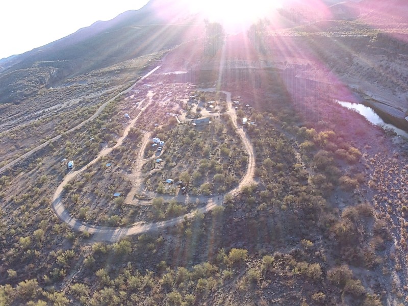
As a drone user of a lower end 4k 3 axis gimbal with electronic image stabilization, ( the HS720 drone), it is wholly unsuited for any prospecting work. I can’t see any value added to a good google map survey or actually walking the few hundred extra feet from where your flying would bring to you. Higher end drones with better cameras and surveying/mapping, maybe. I’ve attached a photo from a jasper and obsidian bearing area and the time would be better spent walking around boots on the ground.
-
 Something Not In The Journal : Back in 2014 one of my partners gave me a phone call and told me to check my email. He was pretty excited and wanted me to see some pictures he had sent. This guy is Vern in the 2002 journal and we are still partners to this day. He specializes in exploration and is known as one of the best gold prospectors in northern California. If there is gold he will find it. He has amazed me more than once. On this particular occasion he was poking around on one of our western claims. He had been taking bucket samples in a little gulley near the base of a mountain and had found trace amounts of gold. I had him checking this area because it showed no signs of previous mining by the old timers. No tailings or signs of a diggins at all. It has been my experience that when you see no sign of previous mining near large workings it is for a good reason - the old miners couldn't find anything worth their time. That's why I always like to explore at or near previous workings - especially those that showed that the old timers put in a lot of hard work. They usually did that for a reason - there was a lot of gold. Anyway, on one of his samples he started finding several nuggets of shiny material. They were about the size of dimes and nickels. He thought they were platinum nuggets and so did I. They were found just several feet below the surface. He ended up taking them to get analyzed and told me they were DSO iron. I asked him what the heck that meant. He said DSO stands for Direct Shipment Ore. Pure iron. When we had a physicist out there he did some lidar work in that area before flying a drone along the fault line 1500 ft to the east. He said there appeared to be a large deposit of iron where Vern had sampled. I found this quite interesting. I'm also wondering if there may be a large gold deposit along with the iron but at a much deeper level. Someday I may find out.
 -
I use to use my cheapish drone to survey some of my personal permissions here in the UK,but with so many regulations coming in its taken all the enjoyment of using a drone,i can get the same basic information by using google earth and Lidar.Of course i can see the advantage of using a drone for prospecting.
-
I have used my cheap drone from Ebay to survey creeks and hills to locate good spots to do some panning. From there I have been able to find good areas for the flour gold that is common here in Illinois. Would I recommend using them in the areas out west, yes I would. Make sure that you have plenty of battery time for the areas that you want to explore.
-
It would be difficult to see the small stuff with a drone that gives evidence about the prospecting potentials of an area, but it could help when looking for those off the beaten track with larger types of evidence of gold potential (pits, drywashing piles,etc.). Sounds like a good experiment to see if it is useful for finding new places. Good Hunting!
-
I used to do mine surveys and mapping for work, and we used a drone to check hard to reach prospect pits and old mine sites to see if they had any open adits or shafts to survey. It saved a lot of money (in time) instead of us hiking up to them. I also used it to help with an archaeological survey to look for rock art up on cliffs and outcrops. Drones for prospecting may help with identifying areas of prior work (old trails, drywashing piles, mine dumps or other worked sites), and looking for areas with outcrops or dikes with prominent mineral deposits. It’s not a new idea, and even Jeff Williams has some videos on his channel where they are also using a drone to look for historic mines.
-
Does anyone here use a drone to help cover more area when looking for places to prospect? If so, how helpful do you think it is?
-
 I would like a coil coverage sensor as well, but it isn't happening with GPS. Not precise enough. If you miss just a square cm of ground coverage then you've possibly missed a target. GPS is never going to give you that level of precision. You need something like drone mounted LIDAR or some other precision optical sensor that is tied into a gyroscopic coil position sensor as well as GPS. I envision something that feeds a pair of Augmented Reality glasses that enables you to peer out onto your site from any position or angle and shows you how much of the site has been "painted over" by one or more sweeping detector coils while the drone or whatever was monitoring them.
 -
I am a new member and am very interested in the subject. I am looking for a used pulse Induction MD for gold prospecting and hope to integrate a drone as well crdill
-
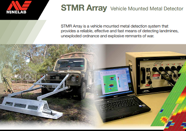
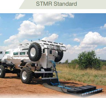
Re-read my post. A person doesn't use the kind of tools I'm talking about for finding nuggets directly. You use large scale, low resolution tools to cover large swaths of land to find indicators, then go in with a 6000 or 7000 and do the higher resolution work. And not everywhere is the Sierras. I posted the STMR only as an example that Minelab is working on stuff other than coil on a stick paradigms, things which over the last few years now might be adaptable to something more mobile like drone whereas not long ago it was thought impossible. GPR already is being used on drones. Other stuff too. If they have the bulk designed for military applications, my point is they might be able to do some sort of drone based consumer product as well. There are tons of examples you can use this equipment to find nuggets by proxy, some of which I'm not at liberty to disclose at the moment. But for example you can use drone mounted GPR to search for buried paleoplacer and paleoriver channels (you are finding the gravel/boulders, not the nuggets), then use that map to go in with a detector or even an excavator. Saving years of boots on the ground surveying/test holes/exploration. Similar techniques abound with other sensor arrays (spectral, radiation, magnetic, etc) which a creative and knowledgable prospector can apply in new ways. You can use these survey techniques to find gold, or almost any other mineral, limited only by your creativity and ability to find new ways to correlated specific types of survey data to indicators or minerals of interest. I'm not guessing, I'm saying this based on real experience, most of which unfortunately at the moment is under NDA but I may detail further in the future if I can. This is the direction the future of general prospecting is going. Most people here think detectors have reached maturity - I'm saying with first hand experience that there are still ways to find both more gold as well as other minerals with some of this tech that is now available. If Minelab is charging pro prices and marketing as pro equipment, I'd like to see them offer some of these at a consumer level now. Those who just want to "swing and hike" are free to do so in any event with what exists already.
-
If we are gonna pay the piper then I'm hoping Minelab is moving to some sort of automated prospecting type packages, specifically drone mounted. Drone mounted GPR is real and a thing already in the exploration industry for example, so some things are now possible that were extremely difficult or impossible 10 years ago. Most of this stuff isn't useful for say finding 1 gram nuggets, or recreational detecting though. It's larger scale, lower resolution, bigger picture. But automated. Then you can come back with a 6000 or 7000 or whatever and do the finer scale, higher resolution work. Minelab has some stuff that seems like they are working on ideas like these already, but limited mostly to countermine military tools. Anyone looked at their STMR Array? Wouldn't be hard to make a smaller adaptation of that to satisfy the drag coil crowd. I keep hoping we are moving from the coil-on-a-stick model. Probably not though. But who knows. But if they are marketing "pro-grade" equipment and charging pro prices, then I feel it's time to give us actual professional exploration tools and not recreational equipment.
-

New Wm09 Wireless For Manticore & Eqx 700/900?
jasong replied to jasong's topic in Minelab Metal Detectors
That's good if its for the Manticore, et all. Because I really want a speaker on whatever new gold detector they come out with, and no external modules because it's just one more thing to keep track of and have to charge...easier to do in town then on an ATV and backcountry. I just drove 800 miles to find out I forgot my WM12. Thankfully that wasn't the first time though, and I found a backup WM12 I bought last time I did this, shoved into a pocket in my ATV that I forgot I had too. I'd love to see a new gold detector, but man, after running that 22" CC, I don't know they can get much deeper than that. Really just want a GPZ+X Coils performance, except way lighter, better in salt, and way improved EMI performance. That'd be pretty much the last machine I'd really need, unless it was some automated drone type prospecting detector or something. I also really want a set of normal, easy to wear glasses that overlays a track of exactly where I've walked onto the ground, so I can keep track of places I still need to detect when gridding. In salt flats where everything looks the same, too easy to miss big chunks of undetected ground. A little VR/augmented reality maybe. I looked into making a set of these myself, I think it's actually possible. But then I got sidetracked looking at adding a Coral.ai tensor unit to the RaspPi and processing all kinds of visual data, and then of course my project got too complicated and I set it all aside and forgot about it as I had 5 other ideas by then, as always, short attention span. -
 Yep all my pictures I'll be posting were taken in my yard far from the actual permission. I recently learned about 3 guys who lost a good permission because they posted their finds on Facebook and did multiple YouTube videos with drone footage showing the landscape. Shortly after the landowners started having problems with trespassing and told them they were no longer welcome and to take the videos and post down. Amazes me what some people will do to get social media views.
 -
Looks like part (chanter/drone) of an old bagpipe?
-
.thumb.jpg.95344db3aeef0a4c6c73420daa366191.jpg)
Making A Drag Coil From Scratch
Valens Legacy replied to Northeast's topic in Detector Prospector Forum
You might have better luck building a unit that can be mounted to a drone. There are used commercial drone that would handle about 25 pounds, and that should be enough to handle the coils and detector that can send information to your phone. Granted it would not get most targets very deep, but if they were large ones it will show you where to dig. -
I could see needing a drone to get the gold out of China, but in??? I’ve flown into Shanghai and other cities in China from the US a dozen times and never once had anyone have any concern on anything I brought in through customs. If they were trying to avoid taxes on the gold or something similar they could have done a number of things… belt buckles… a big ol rodeo belt buckle, long as no one tried to pick it up, lol.
-
Some mighty big nuggets in Russia. A drone would stand out a bit you'd think, good old fashioned car might have been easier.
-
That is a pretty sophisticated looking drone, good on those guys for thinking out of the box!
-
It seems that a big drone was used to collect some gold from Russia to China. Maybe a smaller drone would not have been detected. China busts gang that uses drone to smuggle gold-Xinhua (news.cn)
-
.thumb.JPG.b46839319dc8de4aefe1f42407094dbd.JPG) I guess you could use a drone and camera and try find it?
I guess you could use a drone and camera and try find it? -
I have a wacky idea on the submarine topic - ULF frequencies used by subs and also emitted by certain natural phenomenon are known to travel a good distance through the earth itself and detectable inland like in Colorado and whatnot. Would there be a way to use those existing transmission already deep in the earth as "TX", and just use a lightweight "RX" handheld unit, or even a truck mounted loop? Obviously not for small nugget size targets, but maybe for larger conductive ore bodies for geophysical exploration? Similarly, would it be possible to build a massive "traditional" PI by running 4 stakes over like a 500ft diameter square, then winding a coil over the stakes and using that as a TX mono. Then using a lightweight RX handheld unit that senses the pulse timing for synchronization, use it to scan for really deep targets that are nugget sized? Or potentially a drone or atv mounted RX loop that might not need to be so close to the ground since the TX loop is so large? I'm curious to experiment with stuff like this that I've thought about for a while, but I just never have the time or resources to try.
-
I Determine How Much Ai Understands About Gold Detecting
jasong replied to jasong's topic in Detector Prospector Forum
These language based AI's are not good for that stuff. But clearly we have self driving cars, delivery robots, etc that can handle spatial coordinates and real time visual data. But those are specialized cases, not stuff easy for the public to access like ChatGPT, etc. The problem is anything wheeled runs into rocks, bushes, etc. Anything with a coil that needs to touch the ground runs into the same issue. And anything flying drone based cannot get a coil real close to the ground, plus it's own motors create a ton of noise that makes things like detectors hard to use. I have a few other solutions to larger scale, semi-automated prospecting. But it'd require a lot of tinkering/research/building/failures, and at this point in life I doubt I'll ever have the time to do it since the payoff isn't that great compared to other things I could spend time on.