
Leaderboard

.thumb.jpg.8761b3d9b3da119b9e6d1912f67275ad.jpg)
Popular Content
Showing content with the highest reputation on 03/05/2021 in Posts
-
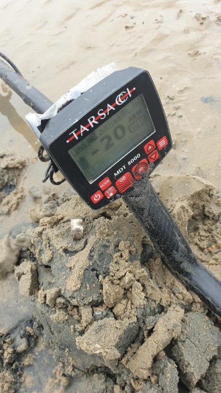
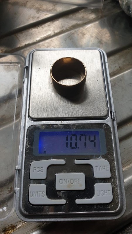
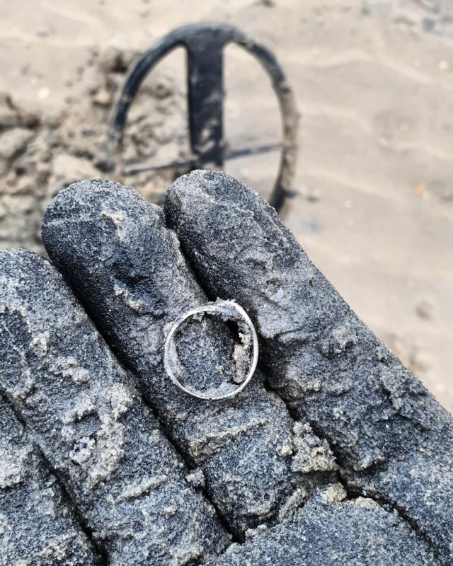
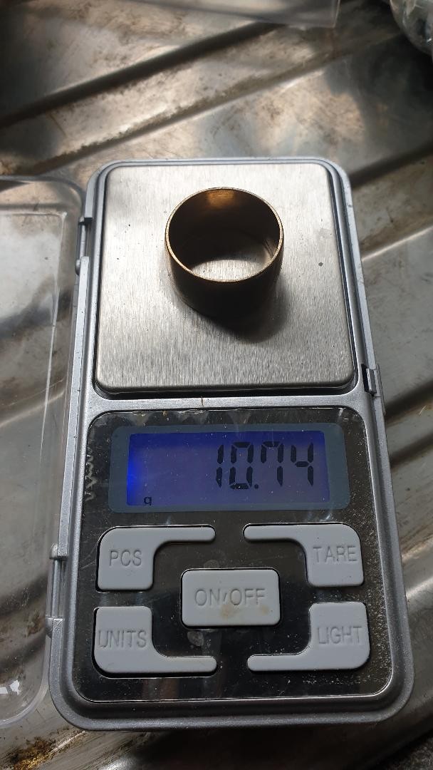
Hello to all , And again i went to the same beach secluded where nothing happen,the road potholes have been filed partially meaning you can go up to 9.5mph😂😂 I started at 7.30 once i found the right spot bullets and shrapnells.... silver ring came up then more of the deep debris from ww2 and then BINGO this nice 9ct ring maybe at 30/35cm. i finally gave up at 10.30 may go back tomorrow

 7 points
 -
With the amount of new people here the last few years it bears repeating on a fairly regular basis that the county recorder is the only place to properly determine what location paperwork has been filed if time is of any concern at all. All of these 3rd party websites like Minecache or yes even Mylandmatters (though they are far and away the best 3rd party site with the most knowledgeable people) are not substitutes for doing any kind of claim research, though many newer people tend to think it's suffices, that is not the case. Why? Multitude reasons. 3rd party sites are at best using the LR2000 (now MLRS) database dumps to update their own databases. This means that they might be up to 2 weeks behind the BLM themselves since it's a bi-weekly database dump. Assuming they update their own databses the day the dump occurs, which probably isn't the case so they might be even further behind. I get the "bi-weekly" database dump from the BLM myself, and I can promise it's often less bi-weekly and sometimes more "whenever we get around to it". I've seen it take 1+ months. The BLM themselves are delayed many months both in processing paperwork as well as data entry. Even in states in which historically they were fairly caught up, they are now behind 3+ months. I know because I file claims often and some of mine which I filed over 3 months ago are only now showing as "filed", which means they won't show up in BLM databases OR 3rd party databases unless you search by serial #, which only I have at the moment so they will not show up in database or mapping searching by my name, geographic location, claim name, or anything else. They do show up at the county recorder though In addition to the BLM delay, a claimaint is not required to file with the BLM for 90 days after location. A period of time I and many others very commonly use since being in the field means no mailboxes to get the county recorded original back quickly, nor access to post offices to send mail to the BLM once that document arrives. 3rd party sites do not give you any actual location information beyond the 1/4 section. That is insufficient to determine what land is actually claimed. So, right now, in states commonly prospected on this forum, I can absolutely guarantee that there are claims ~6 months old at this point (and maybe older) which have yet to even show up in MLRS, let alone any of the 3rd party websites. The 90 day period along with the BLM's internal delays in even processing paperwork received means that location certificates at the BLM may not show up for well over 3 months after staking/filing, so it's not good enough to only research at the BLM either. The county recorder is the only place to go for up to date mining claim status. Any serious prospector going beyond club claims has to familiarize themselves with recorder research. If not, stick to club claims because this is a huge part of prospecting, in addition to understanding the laws. The only exception is when researching federal/BLM specific documents which may or may not be required to file at the recorder, or curable items such as NOIH's, and these the BLM may be the only or at least the first agency to have copies.6 points
-
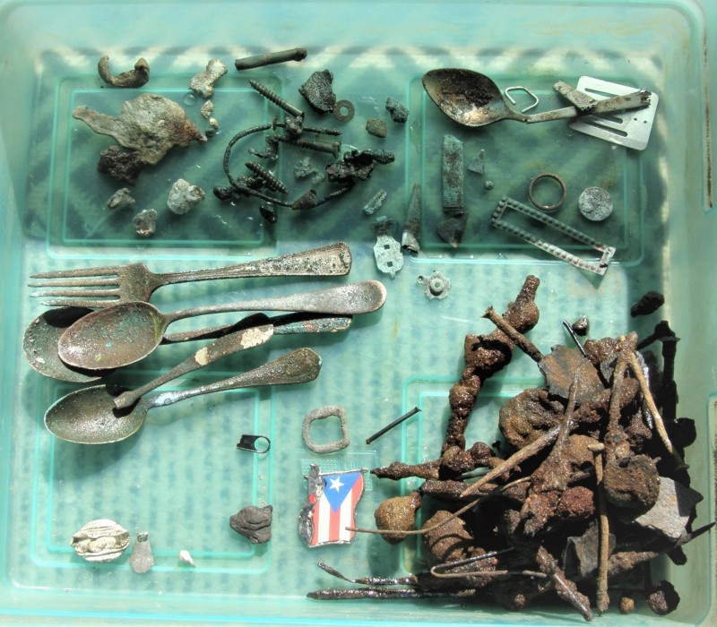
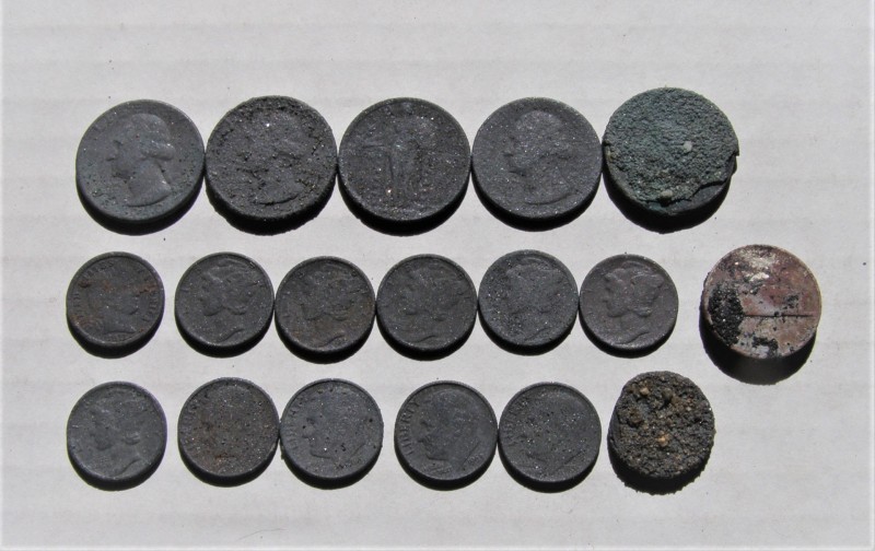
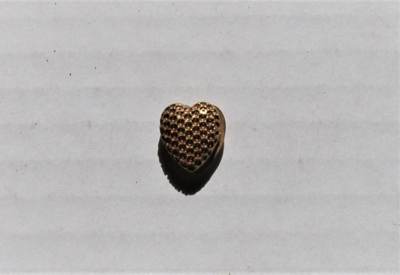
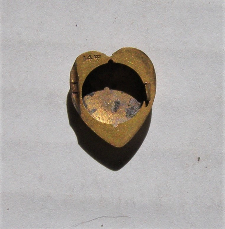
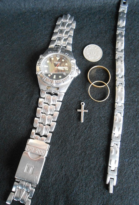
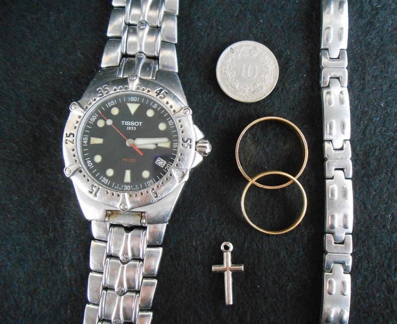
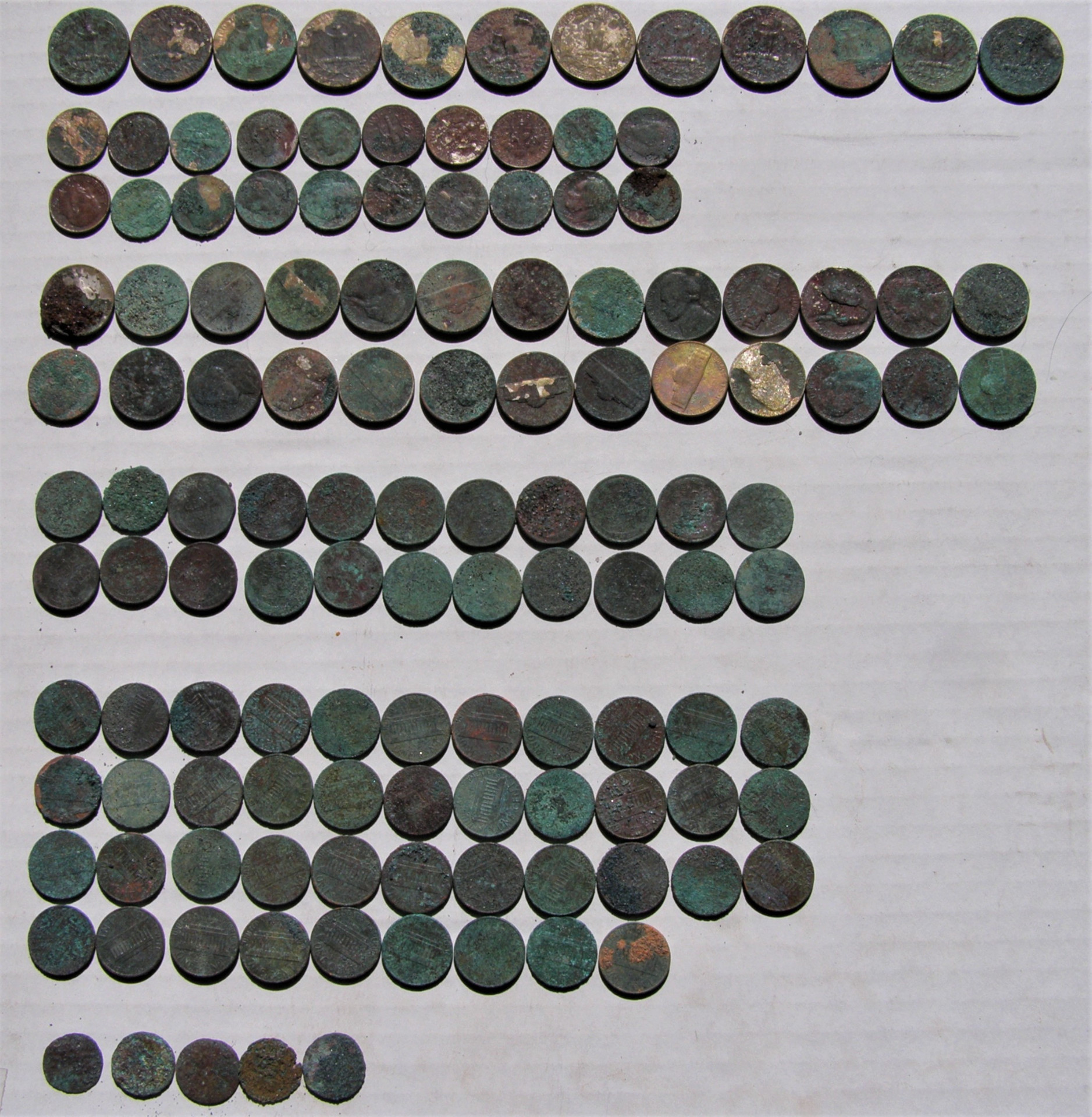
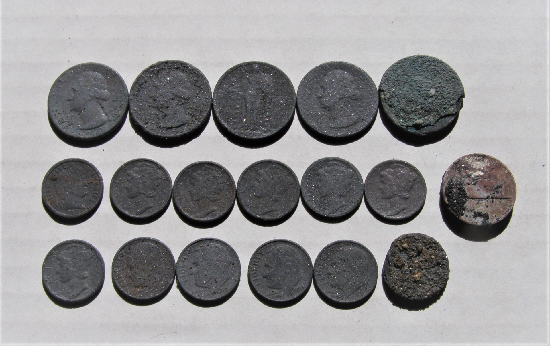
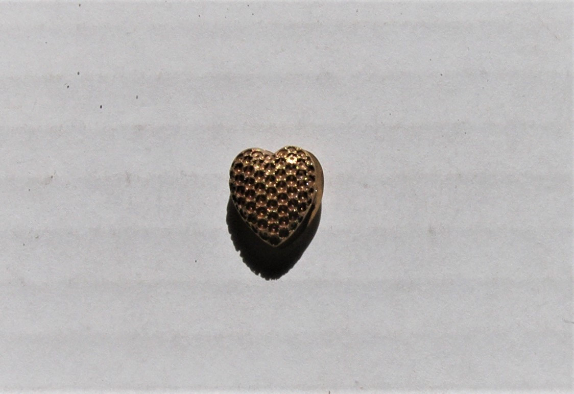
I went back to my silver beach, as I had a fairly good feeling this part of the beach would not change much. It did not and I had a very good day. Spent 7 hours there with the GPX, dug all signals including iron and finally called it quits when my brain said GO HOME! The number of signals in a short span was unreal. I spent some of my time just detecting from my knees, since I could get 4 or 5 signals in very close proximity to the signal I was digging. Most of the time just inches away. Total coin count I believe was 150. 18 silvers, all copper pennies but 1 zinc, so I put that with the trash picture. It ruined my perfect copper penny day and I refuse to put it next to them. 😄 4 Buffalo Nickels showed up, as well as 1 Indian Head Cent, a Standing Liberty Quarter, and a Barber Dime (a rarity on this beach). Also, a nice little locket which I am unsure if it's solid gold or gold filled. It has a 14 stamped on the inside with a maker’s symbol that looks like a variation of Neptune’s 3-pronged spear (Trident). I saw no indication of peeling of the gold, so I am cautiously optimistic I found gold. Of course, with the type of hunting I do, there was lots of junk as well. Got my exercise in for the week and plan on hitting it again soon. Weather was rather nice and sunny, just shy of cold. No matter how old you are, the kid in us still has to play! 🙂
 4 points
 -
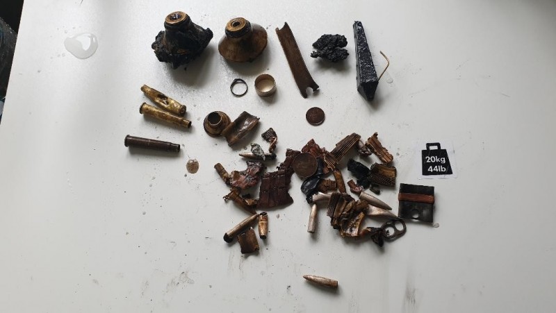
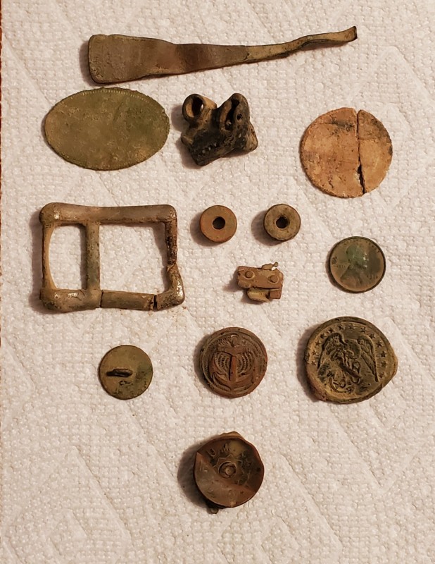
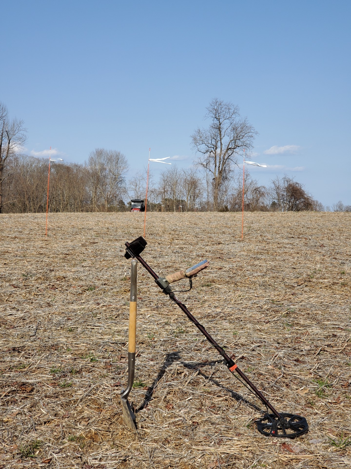
Great day but windy, 20 with gusts to 30. I could hardly hear my headphones sometimes and the wind kept blowing my spade around. Went to the site of an old farmhouse in my permission, at first I just scouted about but then switched to grid search using my flag sticks. It's not a huge area but will take a few days to search completely. Gotta say I was surprised to find any military objects at all. If you read my other posts your know this area never really saw war except for 1812, and that was only a very short skirmish that occurred nearly in my backyard. But find militaria I did! The site is as trashy as the other one I went to yesterday but just in the small area where the house stood. Found a decorated cutlery handle, looks like it might be a small teaspoon. There are marks and decorations, but nothing legible. The oval plate has a coin like border around it but also has nothing stamped or engraved other than the border. Next is some sort of part maybe to a machine or gun. The broken circular object seems to be tin. Large buckle is probably silverplated, it may be military. Two knurled knobs I found far apart that may be for holding a military device but I haven't found it yet! Some weird geegaw and a 1918 wheat penny. It was the last thing I found, It dates the finds somewhat. Saved the best for last, a colonial era button, and two military buttons. The left one I cannot identify but the right one is possibly 1864 to 1866 Marines. I did reverse image search on Goog. Anyone with an id for the other? Last is a shotgun shell , the UMC Union star primer is 1901-1912.
 4 points
 -
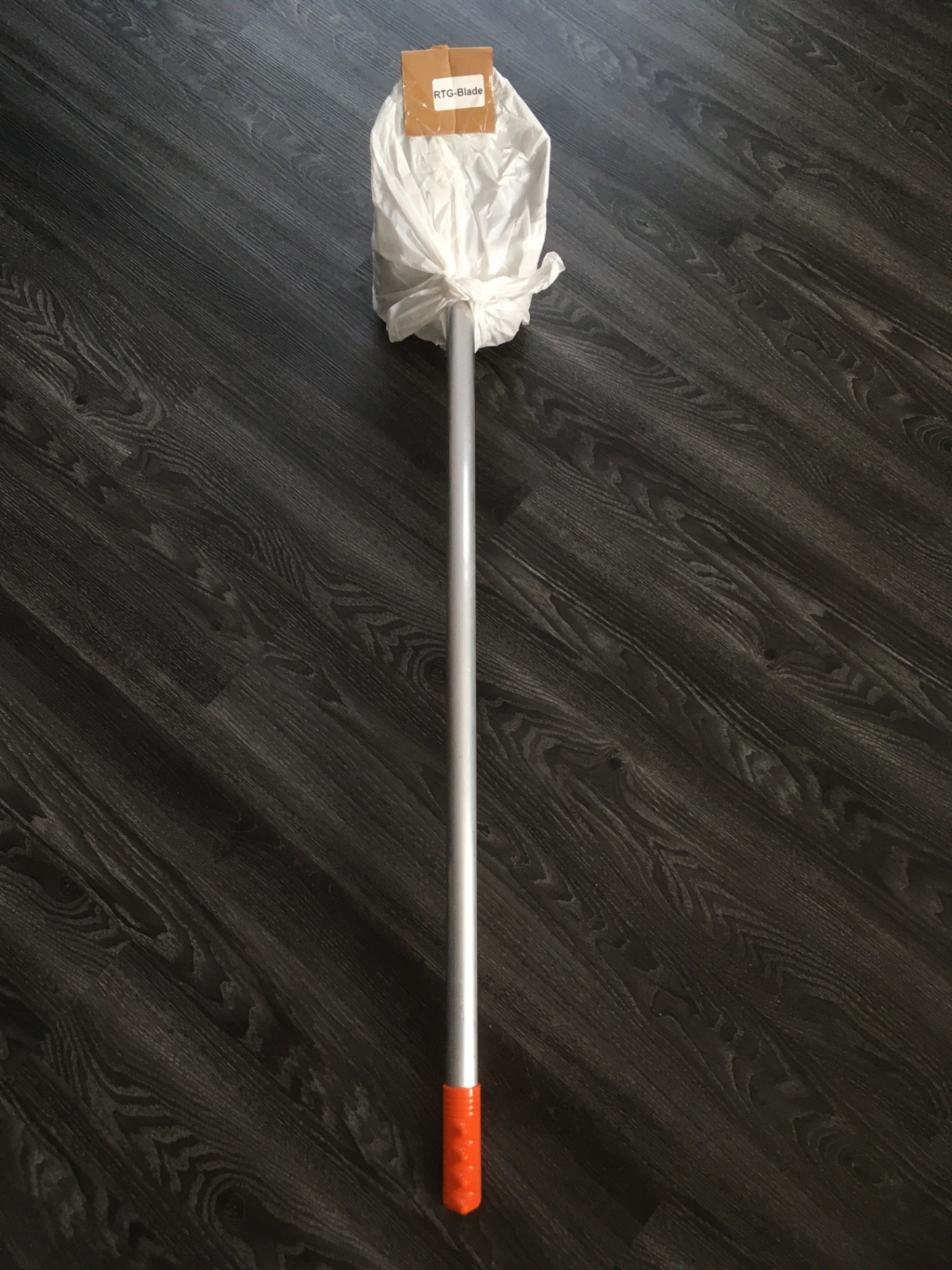
Finally got my RTG Blade today. Seller sent me the non-travel version first which was nice (and a little lighter) but I wanted the travel handle. Seems built really well. Good size. Does have a little play in the overlapping lower part of joint so I may try some teflon or electrical taper to see if I can reduce that. I don’t think it will be an issue though or I’ll notice while using. We’ll see soon.


 4 points
 -
The first thing to understand is that neither the MLRS nor any of the online claims mapping sites show actual areas under claim. On the Land Matters website we make that clear right on the front of the mining claims maps page. The mining claims represented on these maps are only displayed to the nearest section and DO NOT display the actual claim location. Sections are about one square mile and actual mining claim locations can vary considerably from their mapped location. The only way to determine an actual claim location is to obtain the County Recorder Location Notice and amendments for the claim in question, study the mapped location and then find the location marker on the ground. Members of the public and other prospectors do not have the right to determine whether an existing claim location is valid, only a court of record can make that determination. The next thing to understand is the BLM, Land Matters, Diggings and even the pay services do not rely on mining claim locations to present their information. The information is derived from BLM case files which are not based on current claims information. Besides the normal 90 day + lag in location files and records the BLM itself is years behind on updating these case files in several states. Just last week we ran some rough numbers on what percentage of BLM mining claim case files have never been adjudicated by the BLM beyond acknowledging the receipt of a notice. Adjudication is the simple process the BLM uses to determine if your mining claim location is properly described and located on public lands open to mineral entry. Until a mining claim case is adjudicated the BLM doesn't even know whether there is an actual mining claim associated with the notice they received. Here are state by state those percentages of not yet processed mining claims in a simplified format. 4% - Arizona 53% - California 20% - Colorado 10% - Idaho 1% - Montana and South Dakota* 1% - New Mexico 6% - Nevada 3% - Oregon and Washington* 14% - Utah 9% - Wyoming * These States are administered as a single unit by the BLM. As you can see if you are looking at the MLRS in California the information you are viewing is more than likely years out of date and has a slim chance of being accurate. In fact California is at least 2 years behind on processing claims closures so the numbers you see here just the tip of the administrative backlog iceberg. To varying degrees a similar situation exists in all states. The BLM isn't shy about warning you of this situation. On every file you acquire from the BLM you will find this notice in all capital letters and bold type: NO WARRANTY IS MADE BY BLM FOR USE OF THE DATA FOR PURPOSES NOT INTENDED BY BLM The list above should give you an idea of what purposes the BLM intended. Most County Recorders will update their records within two weeks of receiving location notices or amendments. There are notable exceptions to that standard. In particular in California some of the larger counties are far behind due to being closed to the public for the last year or so. Nonetheless the County Recorder's office is an essential stop on the path to determine public lands open to prospecting. What you are up against here is learning a new set of research skills before you can determine where there is open ground for prospecting. This may seem complex, and it is. Despite what appears to be a modern mess of red tape the fact is that successful professional prospectors in the United States have had to master these skills for more than 150 years. It's actually a lot easier now than it was even 20 years ago. It's just one of the many complex skills prospectors must master to be successful. I do this for a living. I can tell you from experience that there are some basic steps that really need to be accomplished even before you look at the BLM files or the County Public Records. The very first thing you need to do before researching claims in any given area is to study the Master Title Plat (MTP) maintained by the BLM. The Master Title Plat is the definitive map of government interests, ownership and past actions on the public lands. It includes patents, mineral withdrawals and ROWS. It's one of the few government documents you will find that doesn't have the giant BLM disclaimer. You can rely on the MTP to be an official government record. Without viewing and understanding the MTP you will waste a good part of your research and prospecting time investigating lands that you have no right to prospect or claim. Thousands of mining claimants waste their time and money every year staking claims that are invalid and will be classified as CLOSED as soon as your state BLM gets around to adjudicating your location notice. The real message here is that you have a legal duty to determine the status of the land before you put boots on the ground to prospect or locate a mining claim. This is known as due diligence and it's a positive legal duty to avoid trespassing. Not just charges of trespassing against a mining claim but trespass on private property or mineral trespass against the United States is a distinct possibility too if you don't do the research before entering these lands.3 points
-
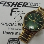
The 'notch' feature on the F75 is a nuisance, and it is easy to accidentally set it wrong, and not realise. I recommend performing a 'Factory Reset' , see the Owner's Manual for details of how to do this. This will clear any peculiar settings you may have got. I notice the central foam piece from the armcup is missing, that is unusual. Also, on the genuine machines I have seen, the 6 bolts that hold the upper armcup to the lower section are painted black, not left shiny silver. This makes me suspect the machine is counterfeit.3 points
-
I’m not so sure it’s the connector as much as the electronics in the control box aren’t shielded. My VALLON PI shields the entire circuit board and they use a 7 pin Souriau bayonet style connector. The center pin is the coil+ and all the remaining 6 pins are tied together as coil- which shields the connector. Maybe Fisher could look at that as a possible fix for the noise. I read one post who says his machine gets noisy when the water is about 6 inches down from the control box. That most likely is movement of the coil cable itself. You need to secure your cable for zero movement the best you can. Good luck everybody and spring is just around the corner here in the US !!!3 points
-
https://www.detectorprospector.com/forums/topic/2595-9-million-worth-of-counterfeit-detectors-destroyed-in-dubai/ https://www.detectorprospector.com/forums/topic/7634-first-texas-pursues-counterfeiters/ https://www.detectorprospector.com/forums/topic/2795-fake-gold-bug-pro-detectors-destroyed/ Minelab Stop Counterfeits Page Known Counterfeit Manufacturers https://www.detectorprospector.com/forums/topic/10993-list-of-legitimate-metal-detector-dealers/3 points
-
The FE0304 meter doesn't have anything to do with the ground phase number. It simply tells you how strong the minerals in the dirt are. The minerals could be magnetic like black sand or they could be conductive such as salt, or some combination of both. You can have dirt that ground balances in the teens and give you a high FE0304 reading because its highly conductive like wet salt, or it could balance in the 50's and 60's and give you high FE0304 readings because its highly oxidized like some red clays and you can have dirt in the 90's give you high FE0304 readings due to black sand. And you can have some combination of both. What is important is understanding how ground with high FE0304 readings affect target signals on your detector. At some point ground mineral strength starts to affect target signals. It will either start masking it, or start interacting with the target response, either raising or lowering the target's phase numbers. In my environment, as the ground mineral strength increases, the target phase number rises and based upon the target conductivity it can quickly wrap around to the iron range, or in the case of tiny targets, completely mask them. The FE0304 meter responses give the operator a heads up about his ground and allows him to make appropriate setting changes to deal with it and/or better interpret his iron signals. HH Mike2 points
-
Pimiento ... 👍 I think you have defined really well what the GB indicator does - it is the "Terain Phase "meter,...... and what is the function of the "Mineralization meter" -it is the "indicator of the strength of the X signal feedback" from the Field ...2 points
-
All the FootPrints were in the process of having the claims updated in the summer of 2019. Sadly my partner passed away in the middle of the process and I've had to put those updates on hold. I still plan to update the FootPrints claims layers and some other features on some of the FootPrint maps but I've been swamped with work from mining companies for the last year. In my opinion the custom geology mapping on the Greaterville FootPrint alone makes it worth the price for anyone that works that area. The 50/50 boundaries are a bonus. The 50/50 area has produced some of the biggest detected nuggets in Arizona history. I've detected and water processed material there. There is a lot of gold in the 50/50 area. I was the caretaker for Kentucky Camp and there has never been a limit on prospecting in any reasonable form although working inside the Kentucky Camp fence line is strongly discouraged.2 points
-
@Clay Digginsand @jasong and others who helped here - just want to thank you for the free time and education you are providing us, I really appreciate your responses, and am sure a lot of us here are benefiting by this - thanks!2 points
-
No it won't show the "actual" boundary because all it shows is land status. I don't recall how many different patents were reconveyed in the exchange but each one is individually shown as reconveyed with split mineral estate. You will have to determine the boundary from that information. I mapped those boundaries back in 2012 as part of the Greaterville FootPrint but there is no public version available beyond the current MTP. Also the MTP is not a geographic map but shows land status in relationship to the Public Land Survey System. There are no common or reference map features on the MTP except Sections and government lots. The land status notation is unique to the MTP and only has a passing resemblance to English language.2 points
-
This is true of the surface of the land and real estate. The problem comes when dealing with the subsurface estate (minerals). In the western United States it's common for the minerals to be owned by a different entity than the surface owner. Greaterville is a good example. What's known as the 50/50 area in Greaterville are old mining patents where the surface has been reconveyed (given back) to the United States along with half of the subsurface mineral rights retained in private ownership. Since half of the minerals belong to a private party you can't locate a mining claim in those areas even though they are managed and designated as public lands. This situation is very common and it's a major part of the reason your first stop in claims research needs to be the Master Title Plat which is designed to show these "split estate" and mineral ownership status issues.2 points
-
Another vote for the steveg counterbalance rod....
 2 points
 -
I've found four Civil War relics in my parks (all from different parks!) yet there were no battles in Indiana (ignoring anything involving Morgan's Raiders -- and although I'm within easy driving distance of those they didn't happen in my town). There are other possibilities: 1) training camps and/or maneuvers, 2) participation in parades on holidays of later years to commemorate soldiers' service, 3) items brought back from war which eventually got dropped/lost. Sometimes these items even had utilitarian value. They weren't rare or even collectible then so they weren't necessarily treasured items at the time they were dropped/lost/discarded.2 points
-
Sounds like that was the problem thanks for the advice! the plan is to go tomorrow to an old property to have a play. Will bury some coins and try learn a bit from there. excited for my first hunt2 points
-
Yup yup , sounds like you just need more time with the detector getting to know each other.......Remember , don't expect too much until the third date ! 😄 Keep your coil under control and on target.2 points
-
The AQ limited has a 15uS setting. The 11.5 is actually 15uS. I think the reason most other PI detectors stop at 15uS is because their circuitry was unable to sample faster than that in salt or heavy mineral locations and still remain stable. That’s not to say though that the unlimited AQ won’t add slower sample rates. We shall see.2 points
-
[UCLA Meteorite Gallery] March 2021 Newsletter http://mail.artnet.net/skins/elastic/images/contactpic.svg From UCLA Meteorite Collection <meteorites@ucla.edu> on 04/03/2021 05:49 PM Details Plain text2 points
-
Try turning down the gain=sensitivity from 99 to 60. You say in static all-metal mode you get a signal from this Phoenecian coin at 1.5 meter distance?? I don't think so.... Also you didn't say what process you are using. The Boost Process ('bP' on the screen) when in discriminate actually affects the detector's performance in All Metal modes also. Try setting to default process ('dE' on the screen) while in discriminate mode. Then go to All Metal mode. Like many detectors, in mineralized ground the numerical target ID's can 'wrap around'. For example, silver objects can show up as iron/ferrous and sometimes iron as non-ferrous. If you are discriminating out the iron range then you won't hear a tone for wrapped-around silver. (But I think the loss of a sound should only occur in discriminate mode. In the All Metal modes you should still hear a signal regardless of how notching/discrimation threshold has been set in discriminate mode.) Note: the Boost Process (bP) and Cache Locating Process (cL) are not on all models, only the Limited (which has a black shaft) and the F75+ (which I think has the '+' sign on the arm cuff). I see a gold shaft on yours so likely you don't have these processes. But you should have others (Fast, Jewelry, Plowed Field). I still suggest the Default (dE) process for debugging. After you've solved your problem you can try out other processes. I like PimentoUK's suggestion (below) of doing a factory reset. See the user-manual for how to perform that. And turning off all discrimination (notching) is also a good suggestion he gave. Keep things as simple as possible when debugging.2 points
-
Coiltek has a 5x10. Bet that would compliment what you have already. Should have similar depth as the 6" but better coverage. Also coil like that might work good for small jewelry. You may find the narrow coil will perform in bad ground really well, elipticals usually do.2 points
-
You can try to contact these guys and see what they have. They made connectors for many detector brands, even custom ones and that might be stock. https://www.switchcraft.com/2 points
-
Here is the Public Land Survey System (Township/Range/Section) kmz for the US, and historic mine and Geology kmz file set for California, and a kmz file for Arizona that I downloaded from USGS in the past. Open each of them with Google Earth and good Internet connectivity. I also suggest closing these kmz files in Google Earth before leaving it, it will try to open the files the next time when you restart Google Earth and it takes awhile otherwise. They are interesting to browse on Google Earth, and were plotted using the information provided by claimants so beware, many of them are within a 1/8th and even a 1/4 section of the real point. Geologic units of California.kmz Mineral Resource Data System 2.kmz Mineral Resource Data System 1.kmz Mineral Resource Data System 3.kmz Mineral Resource Data System 4.kmz Mineral Resource Data System Az.kmz BLM National Public Land Survey System.kmz2 points
-
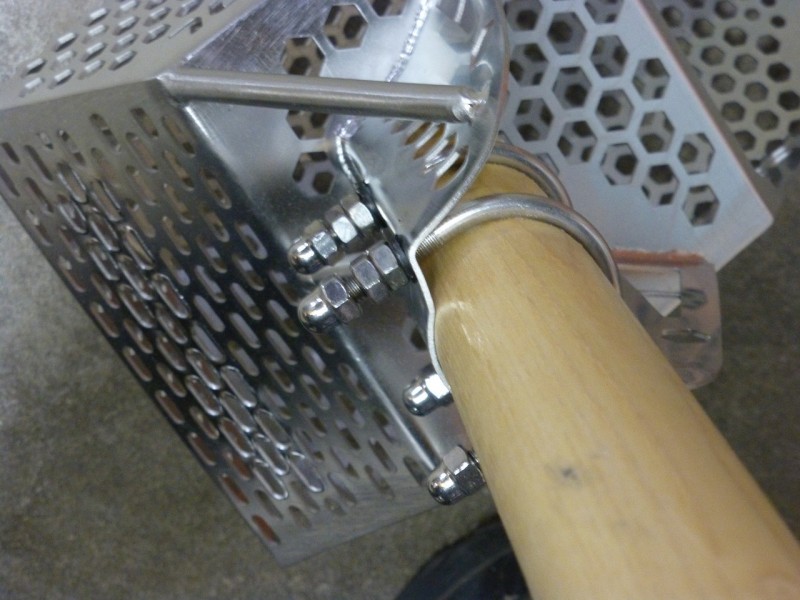
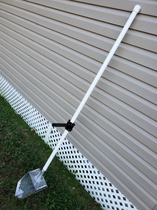
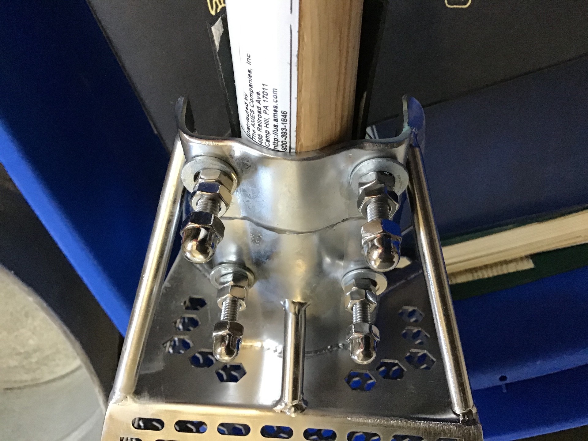
Why they supplied those u-bolts is beyond me. Your foot slips or just carrying around can cause some injury. This is speaking from experience. Option 1 : buy smaller length u-bolts. Option 2 ( what I did , much cleaner) : buy a few slightly larger washers and locknuts ( the kind with plastic in them so they don't unscrew by themselves). 2 washers and tighten down nut , then grind down excess bolt. Bottomline is do what you can to eliminate that excess bolt sticking out.2 points
-
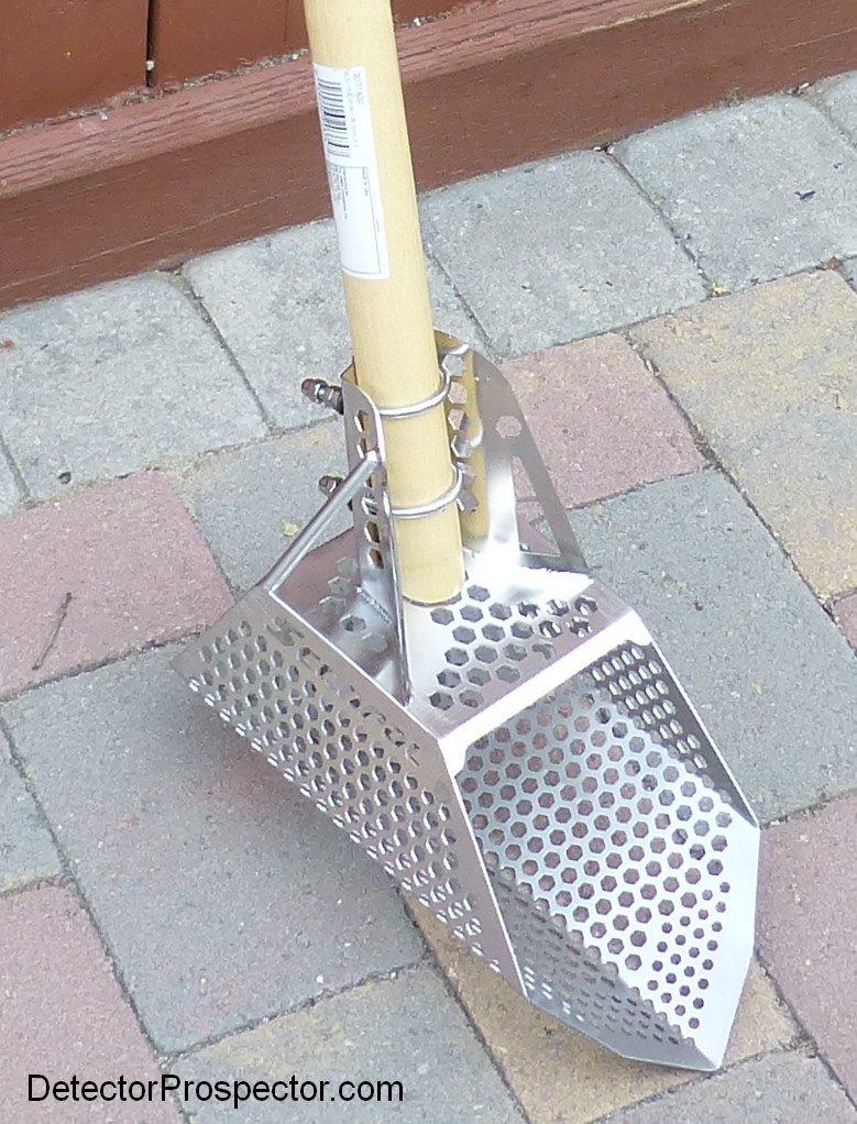
As shown on the last page I picked up an Ames True Temper 2037400 46-Inch ash shovel replacement handle, which fit my hardware without needing shims. The handle tapers at the end, and I sawed the taper off so the bolts fit the thickest part of the handle. I do not think Brian did this above, and you can see the length difference in the u-bolt excess becasue of it. The u-bolts are too long but other than that the hardware supplied with mine is fine. I double bolted and used loctite, so not expecting issues there.
 2 points
 -
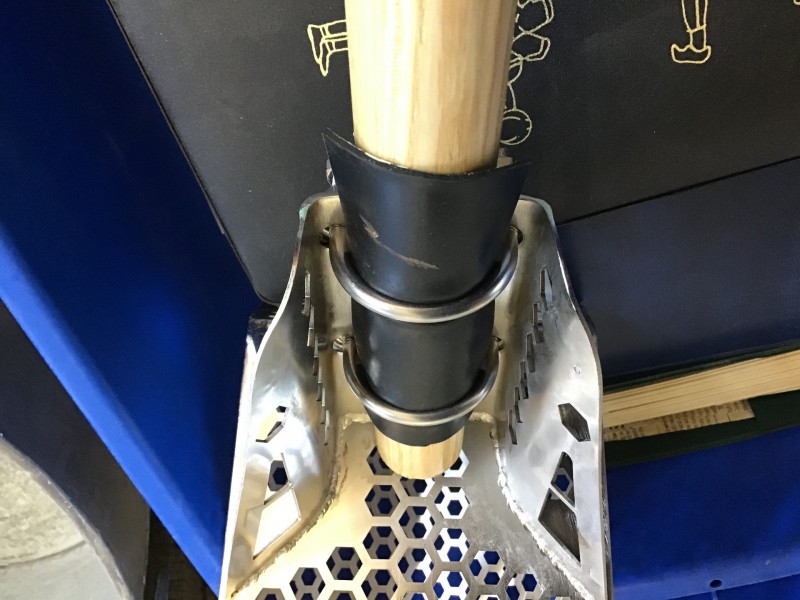
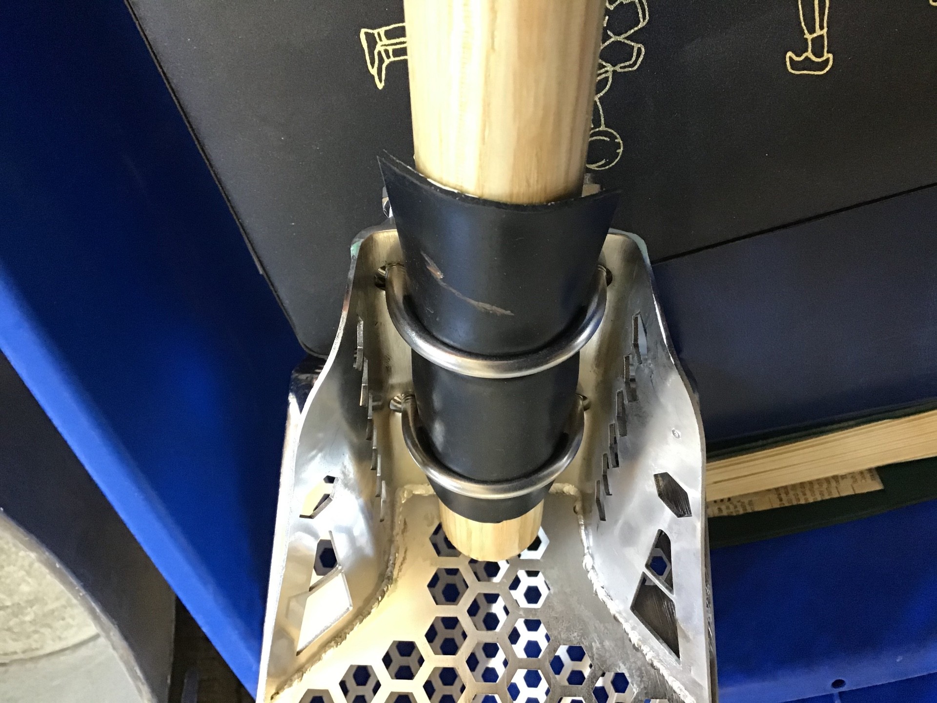
I also purchased the same scoop as Steve, based on his recommendation, thank you Steve. As I was assembling the scoop to the handle,I noticed that the supplied nuts were not going to hold without the help of washers. The drilled holes were slightly and I mean slightly smaller than the nuts, so washers were needed and unfortunately not supplied. I also added a piece of rubber under the “U” bolts to prevent slippage and damage to the wooden handle. This being my first scoop, I don’t know if the rubber is a good idea or not, time will tell. Hope this helps, Brian.

 2 points
 -
It would be nice if the manufactures would let you order a la carte. This detector with this coil and that coil. yea it would take longer and be more expensive but at least you are getting what you want.2 points
-
And the BLM does have Google Earth overlays both for the PLSS and land ownership. USGS has a mines overlay too, which is what Minecache and other websites take and repackage and sell.2 points
-
I use Minecache, overlaid on Google Earth, to see all mines and claims (active and inactive). I think it is the best research tool out there. I use Google Earth because you can also display USGS maps at the same time as you see all active and passive claims and mines. Unfortunately, BLM does not have a good Google Earth map feature so I go and check the land status on the BLM site separately. https://minecache.com/2 points
-
I took coil cover off. Saves over 2oz2 points
-
Look at the rod, shaft, and counterweight system offered by:2 points
-
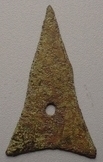
Oh part 5, 6 and 7 coming up.. 😎 Btw I have a cat, his name is Harry as in Dirty Harry the attack cat. Tom would be no match for Harry. Tiftaaft hold on to your shorts I fully intend on bringing you part 5. Here is a pic of a non metal but most likely Chinese artifact from a different location. Just for fun
 2 points
 -
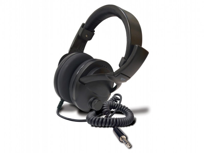
I'm going to try out the new Tek weatherproof headphones with the 8500 They are really designed for use with the armrest headphone jack models like the T2 and F75 but I have an extension cord that allows me to use them with the 8500 These are very nice weather proof Koss models made for 1st Texas. I've had them awhile and I've used them with my F75, Impact and Gold Kruzer, V3 and Etrac. Audio wise I find them to be on par with the White's Prostars. I don't have any problem recommending them and they are reasonably priced. HH Mike https://www.tekneticsdirect.com/products/Weatherproof Headphones These metal detecting headphones are designed by Koss for Teknetics® following our stringent product specifications. They are weatherproof to IPX4 specifications to withstand the harshest weather conditions. Our Headphones have superior sound quality, dual volume control and are noise isolating. Teknetics® has created these high quality, weatherproof headphones ideal for beginner detectorists and professional treasure hunters alike, now at a very affordable price. Weatherproof IPX4 Comfortable Over the Ear Design Dual Volume Control Noise Isolating High Performance Sound Quality 18-20,000 Hz frequency 5 ft 60 in Coiled Cord with ¼” Jack 2 Year Warranty Folds Up for Compact Storage and Convenient Travel
 1 point
 -
So that Master Title Plat will show the actual boundary of the 50/50 correct? It was roughly pointed out to me years ago but I would like to see the boundary lines.1 point
-
This reads like how the UK posts (who have 2000 yrs. more history than us) sounds. Where any/all fields have eventual finds. Great play-by-play.1 point
-
There are a few private property parcels located there the biggest one is the town of GV (53 acres or so). Most of the GV is claimed however there is the large section of which is called the 50/50 land which still holds a lot of gold. Oh the 53 acres is for sale for $500K1 point
-
It is a common error for beginners to try a detector in a yard . But such areas near houses are the worst locations for learning MD because they contain a lot of trash : big and small irons , aluminium bits/foils etc ... The good thing to do is to find a "quiet" area , away from houses , buildings and powerlines . Open fields or woods/forests are good places where to start. As said above the Vanquish series are very reliable machines and I am quite sure that it will go much better for you and your 540 in a quieter area 🙂... HH ..1 point
-
If it’s a patented claim, I would think that’s now private property and should be on the county tax assessors parcel maps with the new owner’s name, an APN number, etc.1 point
-
If you can post a photo of the side of the board with the traces, may be both sides have traces. I can tell you for certain if the photo is clear enough. I have a board for the old classic in kit form from across the Atlantic I am working on. There should be a Voltage regulator for the board, it has 3 large flat leads, the center lead is the negative terminal, also tied to the heat sink, which should lead to a wide trace that boarders the PCB. The black wire goes to the center lead. The red wire will go to the trace that leads to the end of a diode(opposite end from the white band if the diode is black) with no other traces going anywhere except to the diode unless there are wires going to the on/off switch. The diode will have a white band on one end which will lead to the regulator power in, the V reg has a heat sink tab with a hole. This part and the diode should be very close to each other. I have never seen a clear photo of an ST board but that shouldn't matter. The schematics for particular components sections are basically the same up to a point. The power supply design is a standard and the only thing that changes is placement and maybe a few extra components depending on how much polarity protection and filtering capacitors are included. The diode is there to keep from blowing out components in case the battery is connected backwards, which is usually pretty hard to do with polarized connections. It should be rated for at least 1 amp which is not much but that is in forward bias, reverse bias is much more. However anything can be done if you try hard enough like putting the batteries in a holder backwards, it has been done before and touching the battery connector in reverse even for a split second will burn out the circuit parts. I know this gets to sounding like you may not know much about electronics from my end. I don't have any knowledge of how much you do know so I am trying to make this as clear as possible. Again, if you take a good close up photo of both sides of the circuit board it would be a big help but that may be a tough one with all the other wires on the board. You don't mention the model of the detector and schematics seem to be a hard thing to find most of the time for any of the detectors. If this helps, then your are set to repair your unit.1 point
-
Thank you. You have now changed my mind on what looks to be a good , solid and CHEAP alternative for a shaft. I have also used a decent fiberglass shovel handle with a dowel in the past that came out pretty good.1 point
-
I built mine with Schedule 40 PVC, it has a solid Bamboo core and a Raptor handle. It floats, and digs heavy river muck like a champ. Weighs about 4 pounds. 😁
 1 point
 -
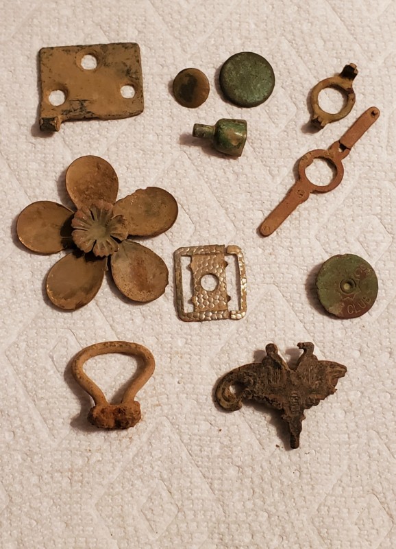
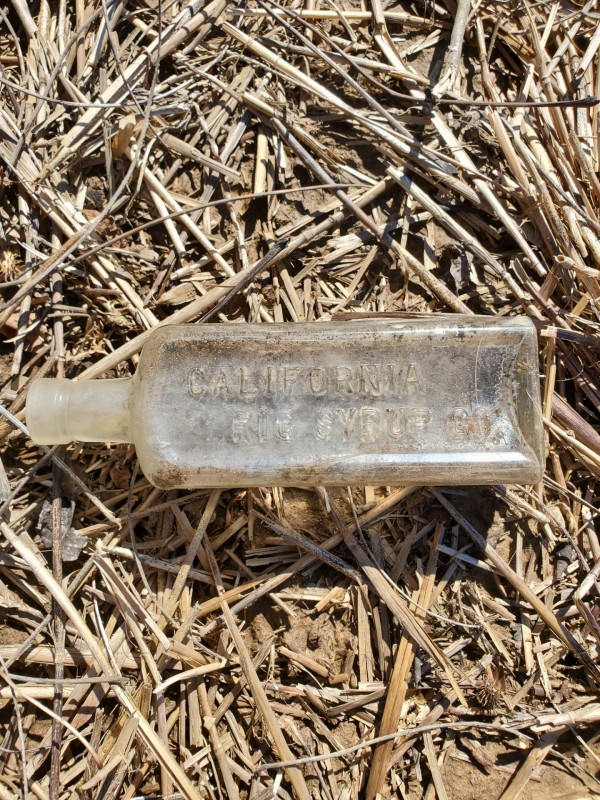
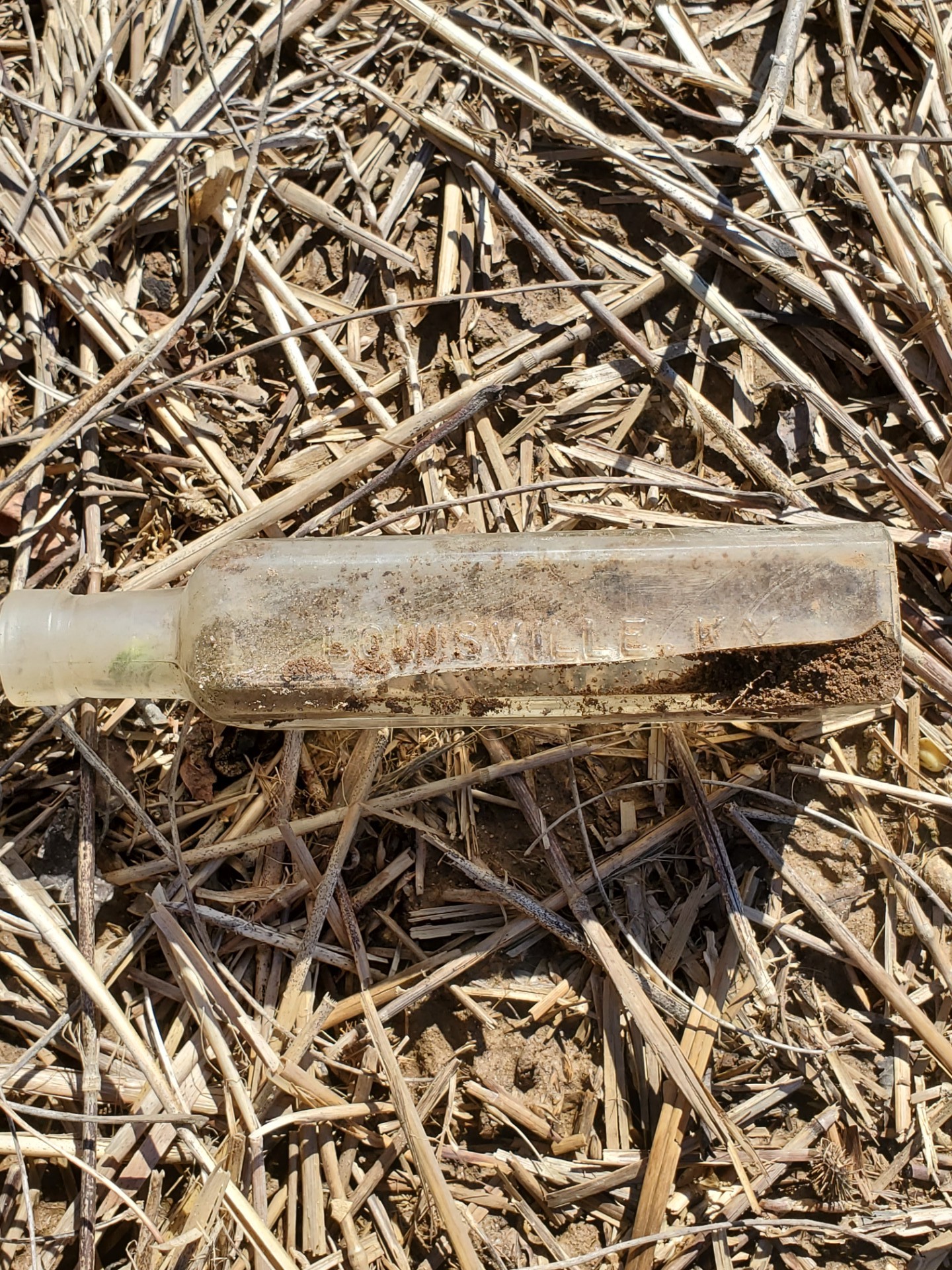
After Part 1 I didn't find anything in that field anymore. I decided to go to a place that @Chase Goldman and I went when he was here, a small area where a house was with a small cemetery. He will attest that this site is so trashy it's hard to take - even in Field 2 with all metal off. We both got tired of hunting it fast! I toughed it out and got the Equinox as quiet as possible. I was determined to find something in all that scrap. Roof steel, can slaw, nails, you name it - and most odd there must be a hundred cat food cans buried there! You get a nice 32 and say "$#&+" when you dig it up. Didn't do too bad, but I'm sad I didn't find a single coin today, I wanted to get an idea of what period I'm dealing with up there. I did dig one old shotgun shell which helped - it is a UMC New Club 12 gauge, circa 1892. Got a couple of colonial buttons, both with shanks. Always like buttons. The most interesting things are the brass flower that I found in parts, and the large whatzit on the bottom. It appears to have a threaded point and is highly decorated, it was a solid 22. The suspender slide might be silverplated. I found both pieces in the same hole. Took a look in the woods where the buildings were pushed, and found the bottle in the next photos. It's old, blown glass into a mold. Sad it's broken somewhat. I thought it was kinda funny that "California Fig Syrup" came from Louisville Kentucky. 😀
 1 point
 -
Yep, any kind of large metal target (bigger than a coin) especially chain link fencing or metal supports or posts can be picked up from a distance of even two feet or more depending on their thickness, by the top, sides or bottom of your search coil even with conservative sensitivity settings.1 point
-
par étroit, il veux dire fin ! sur l'or, le son est très fin et il s'étire a l'accroche et a la sorti / quand on passe la cible sur l'alu c'est beaucoup plus brutal / quasi du on/off on ne peux pas entendre la différence a l'air libre et avec un hp et plus le sable est compact plus la différence est net.. + ma dernière sortie, que du léger et une tissot qui fonctionne toujours elle était encore a l'heure d'été et dans du sable noir :))
 1 point
 -
I have worked on the Brother of the Sovereign and experimented with several audio amps. They work on the Minelab Excalibur but only using All metal where you can seperate the Threshold from the volume. One of the better was DOC's Audio amp. See if I can pull up some old pictures. I did end of finding I could make a set of head phones that worked as good as the Amped up set and water proof.1 point
-
Hmmm. I did say 'Nothing really to do with hotness' ... which probably doesn't translate transatlantically. It means: 'not much to do with hotness'. Hence my statement giving an example of one common correlation: - strong ground ,and '90' GB ( machine dependant) So ... I'll try and explain it. Ground signal comprises two components: A 'Zero degrees' component, caused by the microscopic iron and rusted iron that is spread throughout the ground. A '90 degrees' component, that's attributed to the electrically-conductive minerals ( carbonates/chlorides/sulphates etc ) dissolved in the water in the ground. These two add together, in Vector fashion. Meaning there is one ground signal, that has a phase relationship to the detectors transmitted signal. It's possible for the detector to measure this amplitude, and the phase. This is often done by resolving the single ground signal into its two constituents, 'zero degrees' and '90 degrees' , then doing some mathematics. The phase is ( after some manipulation ) what is presented as Ground Balance' . The strength of the 'zero degrees' signal is presented as the 'mineralisation strength'. As examples: *Mild ground ,typical UK stuff: 'Zero degrees' = 10 units; '90 degrees' = 2 units Phase is 11.3 degrees, GB display reads '70'. Mineral bargraph reads "1 bar, 0.03% magnetite" ----------- *Tennessee devil dirt: 'Zero degrees' = 1000 units; '90 degrees' = 2 units Phase is 0.11 degrees, GB display reads '89'. Mineral bargraph reads "5 bar, 3% magnetite" ------------ *Some weird salty ground, maybe where "Monte" lives 'Zero degrees' = 35 units, '90 degrees' = 35 units Phase is 45 degrees, GB display reads '40' . Mineral bargraph reads "2 bars, 0.1% magnetite" I hope that made sense ( and I hope it's reasonably correct, I don't want Carl moaning too much ).1 point
-
Rusty bottle caps is the one undesirable target (make that only target) that I've confirmed a repeatable difference in responses between F2=0 and F2=9. In my current sites I don't have many sheet metal scaps and only a few rusty steel cans (and pieces) so I've compiled no evidence either way. But I've been to those kinds of sites so I will definitely experiment with IB when those situations present themselves. (More data needed.) BTW, I'm a 'doubting Thomas' to the extreme. I'm also anti-authoritarian in the sense that just because an authority says something doesn't make it 100% true/fact. However I am more likely to accept claims by some than others, so in that sense I'm not purely anti-authoritarian. (And if you want to see the opposite extreme -- giving 100% acceptance to those who you consider authorities -- you can end up with the chaos we've been seeing in the world lately, thanks in large part, but by no means exclusively to, social media.) There are some things I've read here from knowledgable posters which in the end haven't helped me, and sometimes are even contrary to my experiences. However, that could well be because either I'm not executing properly or because I don't have the skill set to appreciate those recommendations. Initially I was bothered by that. Now I just give things a try (usually on multiple occasions after some thought) and if they don't deliver what I expect I move on. I haven't given up on IB improving my detecting experiences. At the same time, I haven't seen any advantage so far from my by far toughest trash target -- nails. I will continue to investigate next time I'm out with the Equinox.1 point
-
There are a lot of posts with good information but every once in a while one comes along that is so densely packed that it's worth bookmarking for repeated reading. Steve, you've created another one of those. Thanks!1 point


.thumb.jpg.d71314a45f3dc82bf75ac1b96e7e9201.jpg)